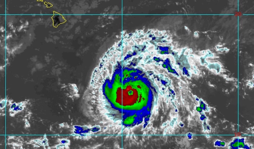
| Above: Infrared image of Hurricane Lane at 2100Z (5 pm EDT) Monday, August 20, 2018. Image credit: RAMMB/CIRA/CSU. |
Tropical storm and/or hurricane impacts are looking increasingly possible for parts of Hawaii as ferocious Hurricane Lane continues to chug across the central Pacific. As of 5 pm EDT Monday (11 am HST), Lane was located about 580 miles southeast of Hilo, heading west at 12 mph. Lane’s top sustained winds had increased to 130 mph, making it a low-end Category 4 storm. Data from Hurricane Hunter flights into Lane on Sunday night and Monday confirmed that the hurricane was maintaining its strength. Update: At 11 pm EDT Monday (5 pm HST), Lane's top winds remained 130 mph.
Lane is arriving hard on the heels of Hurricane Hector, which passed about 120 miles south of the Big Island as a Category 3 hurricane less than two weeks ago. As of Monday, Lane’s current track was positioned about 175 miles south of Hector’s track—which might give you the impression Lane will pass well south of Hawaii. The difference this time is that steering currents will be weakening as Lane approaches Hawaii, so the hurricane is expected to begin arcing sharply northwestward by Wednesday. This will give it a better chance than Hector of affecting the islands directly. The big questions are how soon the turn will happen, how sharp it will be, and how strong Lane will be if and when it reaches Hawaii.
Preparing for our second NOAA P-3 flight into Major Hurricane Lane in the Central Pacific! pic.twitter.com/Z25IyU0Ql9
— HRD/AOML/NOAA (@HRD_AOML_NOAA) August 20, 2018
Track and intensity forecast for Lane
Lane is currently being steered by a broad upper-level ridge of high pressure that extends across most of the subtropical Pacific. A break in this ridge is predicted to develop by midweek as a trough of low pressure digs into the Central Pacific. Lane’s turn will depend critically on how large a break develops in the ridge and exactly where the break is located. Two of the wild-card factors are typhoons Soulik and Cimaron. As they move in parallel across Korea and Japan later this week (see below), they will pump up the western half of the ridge. This, in turn, could help induce a stronger trough and a more pronounced break in the ridge downstream. These interactions can be very difficult for global models to capture accurately, which adds an extra note of uncertainty to the track forecast.
Over the last couple of days, all of the model track guidance has shifted gradually closer to Hawaii, although the usually reliable European model has consistently kept the hurricane further from the islands than the GFS and HWRF models. The latter two models have also depicted a sharper right turn than the Euro. In its 5 pm EDT discussion, the Central Pacific Hurricane Center noted: "...in this situation, forecast confidence is lower than normal."
Sea surface temperatures in the vicinity of Lane will remain in the 27-28°C range (81-82°F) throughout the next several days. These readings are about 0.5°C above average, and they will be more than adequate to sustain Lane. Moreover, Lane will encounter increasingly deep waters of at least 26°C (79°F) as it approaches the islands. Wind shear is expected to remain light to moderate (10 knots or less) through at least Wednesday, which will further support Lane’s ability to maintain its strength. Later in the week, as steering currents weaken, Lane will undergo increasing southerly wind shear, which is likely to induce some weakening. Nevertheless, the prudent course is to assume that Lane could maintain hurricane strength as it approaches Hawaii from the south or southeast. The hurricane may take a sharp turn toward the west at some point after its northward jog, further complicating the track forecast.
 |
| Figure 1. A sampling of the many track forecasts produced by various computer models for Hurricane Lane as of early Monday, August 20, 2018. This is not an official forecast, but but these are used as guidance for creating the projected path. Image credit: weather.com. |
 Monday, August 20, 2018") |
| Figure 2. Forecast “cone of uncertainty” for Lane as of 5 pm EDT (11 am HST) Monday, August 20, 2018, issued by the Central Pacific Hurricane Center. The width of the cone is based on historical forecast errors for past tropical cyclones in this region. Forecast uncertainty is larger than normal for Lane. Image credit: NOAA/NWS/CPHC. |
There are few analogs for a northward-bending hurricane affecting the Hawaiian islands, but the ones we do have are worrisome. The most prominent is Hurricane Iniki, which made a 90-degree turn, then strengthened and slammed into Kauai from the south as a Category 4 storm on September 11, 1992, with top sustained winds of 145 mph. Few Central Pacific hurricanes take such a hard right turn, and model guidance for the region was very limited at the time. As a result, there was no hurricane watch or warning in effect for Kauai until less than 24 hours before landfall. Iniki resulted in six deaths and left $3.1 billion in damage (1992 dollars), making it the islands’ costliest hurricane on record by far. More than 1000 homes were destroyed, along with a large fraction of Kauai’s infrastructure.
On August 5, 1959, Hurricane Dot passed just 90 miles south of the Big Island as a Category 4 storm before veering toward the northwest. The hurricane weakened to Cat 1 strength before striking Kauai, but it inflicted major damage to agriculture on the island. There are no other direct hurricane landfalls on record for Hawaii. Hurricane Iwa passed about 20 miles northwest of Kauai in November 1982, putting the island on the dangerous right-hand side of the Category 1 storm.
The bottom line: Lane’s current strength, the unusual path indicated by models, and the unusually warm waters along that general path all suggest that this hurricane will need to be watched very closely for potential impacts to any or all of the Hawaiian Islands. Even if Lane does not make a direct hit, it will be capable of bringing high winds, huge surf, and very heavy rain, especially on its north and east sides.
 and Cimaron (lower right) at 1930Z (3:30 pm EDT) Monday, August 20, 2018") |
| Figure 3. Infrared Himiwari-8 satellite image of typhoons Soulik (upper left) and Cimaron (lower right) at 1930Z (3:30 pm EDT) Monday, August 20, 2018. Image credit: CIMMS/SSEC/University of Wisconsin. |
Typhoons Soulik and Cimaron: Rare twin landfall possible on Korea and Japan
It’s not every day you have one tropical cyclone striking near Seoul, South Korea, while another is coming ashore in central Japan. This improbable outcome could become reality on Thursday morning EDT, based on current forecasts for Typhoon Soulik and Typhoon Cimaron.
Soulik was the more formidable of the two storms on Monday. The Joint Typhoon Warning Center (JTWC) rated Soulik as the equivalent of a Category 3 hurricane at 2 pm EDT, with top sustained winds of 115 mph. Soulik was a dramatic example of an annular cyclone, dominated by a huge eye (roughly 75 miles wide) and a single intense ring of showers and thunderstorms (convection). Annular hurricanes are typically more resistant to weakening.
Massive eye on Typhoon #Soulik as it approaches Asia, after it had an eyewall replacement cycle and increasingly has the structure of an #annular typhoon/hurricane (single circular ring of convection rather than a lot of spiral bands). pic.twitter.com/eTWr5LwCwi
— Stu Ostro (@StuOstro) August 20, 2018
The mega eye of #typhoon #Soulik, seen up close from the #Himawari-8 satellite. The Cat. 3 storm is expected to hit southern #Japan and the Korean Peninsula by mid-week. See more: https://t.co/P1F11zXUHI pic.twitter.com/4VPXOVuOPQ
— NOAA Satellites (@NOAASatellites) August 20, 2018
Soulik’s gradually recurving path will send it across very warm water toward the southern end of the Korean Peninsula, where it may scrape along the southwest coast before coming inland near Seoul, possibly as a strong tropical storm or Category 1 hurricane. A coast-scraping trajectory would likely weaken Soulik’s winds before they reached the Seoul area, a megacity of around 25 million. The biggest risks could be torrential rainfall (locally 10” or more) and potential flooding across the peninsula, especially the west coast of South Korea.
The current forecast track from JTWC for Soulik is an unusual one. In records going back to the late 1940s, South Korea has been hit by fifteen Category 1 or stronger typhoons. Only two of those made landfall along the west coast of Korea near the capital of Seoul. The predicted track and intensity of Soulik are similar to that of Typhoon Kompasu of 2010, which made landfall near Seoul as a Category 1 storm; Kompasu killed twelve people and caused about $60 million in damage. According to EM-DAT, the international disaster database, South Korea’s has had two billion-dollar typhoons: Typhoon Maemi of 2003, which hit the southeast portion of the country as a Category 3 storm, causing $4.5 billion in damage (2003 dollars), and Typhoon Rusa of 2002, which hit the south coast as a Category 1 storm, causing $4.2 billion in damage (2002 dollars). The deadliest typhoon in South Korea’s history was an August 28, 1936 storm that took 1104 lives.
 |
| Figure 4. Past tracks of significant tropical cyclones affecting the Korea Peninsula. Image credit: NOAA Historical Hurricane Tracks. |
Cimaron, a Category 1 equivalent at 2 pm EDT Monday, was a highly asymmetric system but was steadily organizing on Monday and could reach Category 2 strength by Tuesday. The typhoon’s strength could be dented as it passes over the relatively cool waters churned up by Soulik. The JTWC projects Cimaron to be a Category 1–strength typhoon recurving across central Japan, perhaps just west of Kyoto, on Thursday local time. Cimaron should be moving briskly, as both it and Soulik become caught up in strong southwesterly upper-level flow, but heavy rains and high winds could affect a broad area, especially on Cimaron’s eastern flank.
All quiet in the Atlantic and East Pacific
Despite one U.S. state (Hawaii) watching a hurricane warily, the Gulf and Atlantic coast are in the clear for now. The five-day tropical weather outlooks issued by the National Hurricane Center on Monday afternoon showed no systems of concern expected in either the Atlantic or East Pacific through Saturday.
Dr. Jeff Masters contributed to this post.


