Above: True-color GOES-16 satellite image of Potential Tropical Cyclone 6 at 12:50 pm EDT August 30, 2018. Image credit: Levi Cowan, tropicaltidbits.com. |
A strong tropical wave that emerged from the coast of Africa on Thursday morning is likely to develop into Tropical Storm Florence by Friday, and was labeled Potential Tropical Cyclone Six (PTC 6) by the National Hurricane Center. Favoring development of PTC 6 are warm sea surface temperatures (SSTs) near 28°C (82°F), and the fact that the dry air and dust of the Saharan Air Layer (SAL) lie well to the north of the system. Wind shear over the eastern tropical Atlantic is a moderate 10 – 15 knots, also favoring development.
Though PTC 6 did not yet have an organized surface circulation as of Thursday afternoon, it is likely to bring tropical storm conditions to the southern Cabo Verde Islands on Friday and Saturday, which prompted NHC to begin issuing advisories on the system before it earned the name Florence. PTC 6 is likely to being rainfall amounts of 4 - 8” to the southern Cabo Verde Islands through Sunday; some of the islands may also experience winds of minimal tropical storm force (40 – 45 mph) at the height of the storm. All of the leading models show development of PTC 6 into a tropical storm by Friday, and in their 11 am EDT Thursday advisory, NHC gave the system 2-day and 5-day odds of development of 80% and 90%, respectively. Steering currents favor a west-northwesterly to northwesterly track over the next week, and PTC 6 is very unlikely to affect the Caribbean or U.S. East Coast.
 |
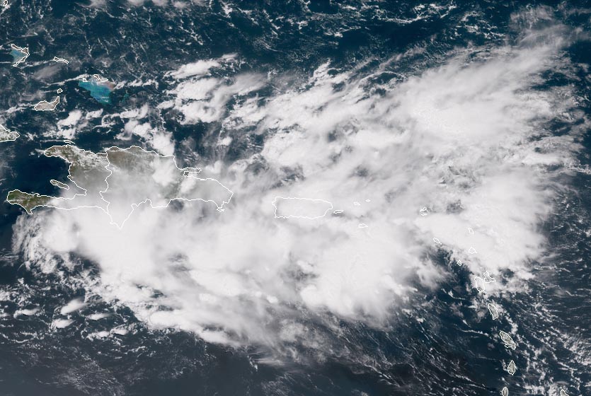
| Figure 1. A tropical wave over Hispaniola and Puerto Rico, as seen at 1:30 pm EDT August 30, 2018. Image credit: NOAA/RAMMB. |
Tropical wave near the Dominican Republic is a Gulf of Mexico threat next week
A tropical wave located on Thursday afternoon near the Dominican Republic was headed west to west-northwest at 10 – 15 mph. This system has the potential to develop into a tropical depression next week in the Gulf of Mexico. Satellite images and Puerto Rico radar on Thursday afternoon showed that the wave was generating a moderate amount of heavy thunderstorms over Hispaniola, Puerto Rico, the Virgin Islands, Leeward Islands, and the surrounding waters, but the system had very little spin. A flood advisory was in effect for much of Puerto Rico on Thursday afternoon. High wind shear of 30 knots was very unfavorable for development, and the wave is expected to continue to battle high shear through Sunday as it moves over Hispaniola, eastern Cuba and The Bahamas. None of the operational versions of our top three models for predicting tropical cyclone genesis--the European, GFS, and UKMET models--predicted in their 12Z Thursday runs that this wave would develop into a tropical depression by Tuesday.
 |
Figure 2. Radar image from 2:10 pm EDT August 30, 2018, showing heavy rains from a tropical wave affecting Puerto Rico and the Virgin Islands. |
On Monday, the wave is expected to enter the eastern Gulf of Mexico, and recent runs of the European model have been predicting a drop in wind shear that will allow the wave to organize into a tropical depression by Tuesday or Wednesday. However, the 12Z Thursday runs of the European, GFS and UKMET models show wind shear remaining high, and do not develop the wave early next week. The 12Z Thursday GFS model did show development late next week, just off the coast of Texas. In their 2 pm EDT Thursday Tropical Weather Outlook, NHC gave the system 2-day and 5-day odds of development of 0% and 10%, respectively.
 |
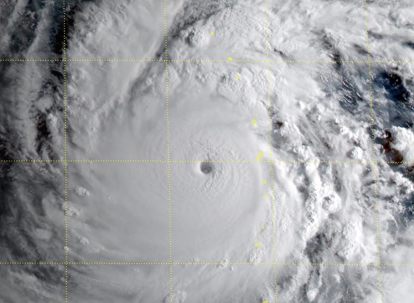
| Figure 3. Visible-wavelength images of Hurricane Norman at 1620Z (12:20 pm EDT) Thursday, August 30, 2018. Image credit: tropicaltidbits.com. |
Stormin’ Norman caps off off the busiest month in East Pacific history
The Northeast Pacific has been churning out intense tropical cyclones at an unprecedented pace this year. In fact, as of Wednesday, the month of August had already produced more accumulated cyclone energy (ACE) between the International Date Line and the Americas than any other month on record, according to Phil Klotzbach (Colorado State University). The ACE index incorporates both the strength and longevity of tropical cyclones.
Another record fell by the wayside on Thursday morning (see embedded tweet below) as Hurricane Norman rapidly intensified to Category 4 strength. Norman will add substantially to the August ACE total in the Northeast Pacific before the month is through.
#Norman is the 5th Category 4-5 #hurricane of the 2018 Northeast Pacific (to 140°W) season to date - the most through August 30 on record. Old record was 4 Cat. 4-5s by August 30 set in 2014 and equaled in 2015. pic.twitter.com/3q94uc4uWl
— Philip Klotzbach (@philklotzbach) August 30, 2018
Located about 630 miles west-southwest of Cabo San Lucas, Norman was packing top sustained winds of 150 mph as of 11 am EDT Thursday. Norman vaulted from tropical storm to Category 4 intensity in just 24 hours, with an increase in sustained winds estimated at 70 knots, and from tropical depression to Category 4 strength in a mere 42 hours. Norman will likely peak on Thursday, providing the spectacle of a top-end hurricane that poses no threat to land. Wind shear is moderate (10 – 15 knots), and a moist mid-level atmosphere (relative humidity around 70%) and warm SSTs of around 29°C (84°F) are giving Norman plenty of opportunity to intensify. The official NHC forecast brings Norman to Category 5 strength later Thursday. A gradual weakening trend is expected to kick in by the weekend, as wind shear steadily increases and sea surface temperatures along Norman’s path slowly decrease. If Norman remains a fairly compact hurricane, it could weaken more quickly than expected.
Norman will be arcing toward the west-southwest for the next couple of days, then angling back to the west-northwest early next week. The long-range European and GFS models agree that a persistent weakness in the steering flow around 150°W will allow Norman to move well north of the Hawaiian Islands before it reaches their longitude later next week. The track outlook is still subject to change, though, so residents of Hawaii should keep an eye on Norman’s progress. Norman will track further north across cooler waters than did hurricanes Hector and Lane on their closest encounters with Hawaii (which were from the south), so Norman would likely be considerably weaker than those two hurricanes before it had any potential interaction with the islands.
Hurricane Miriam, about 940 miles east-southeast of Hilo, is yet another player in the Central and Eastern Pacific’s hyperactive August. As of 11 am EDT, Miriam had top sustained winds of 80 mph. Some modest intensification is possible by Friday before wind shear and cooler waters begin taking their toll on Miriam. The hurricane is expected to carve out a northwestward-arching path, remaining a few hundred miles to the north and east of Hawaii. As it does so, Miriam will help reinforce the weakness in the steering flow that’s expected to help keep Norman from threatening Hawaii.
 |
| Figure 4. Visible-wavelength Himawari-8 image of Super Typhoon Jebi as of 2107Z (5:07 pm EDT) Thursday, August 30, 2018. Image credit: RAMMB/CIRA/CSU. |
Category 5 Jebi a growing concern for Japan
Typhoon Jebi was putting on a major show of strength in the Northwest Pacific on Thursday, and it poses an increasing risk of impacts to Japan early next week. Jebi has rapidly intensified, with top sustained winds of 160 mph making it a Category 5-strength super typhoon as of 18Z (2 pm EDT) Thursday, according to the Joint Typhoon Warning Center (JTWC). Jebi was moving through the U.S. commonwealth of the Northern Mariana Islands late Thursday local time, with the northern eyewall roaring over the tiny uninhabited island of Pagan.
Appears the eyewall of #Typhoon #Jebi is nailing the Northern Mariana Islands right now, particularly Pagan, Alamagan. I can't imagine riding this out on a small, volcanic island at night. (Himawari 8 images: CIRA/RAMMB, JMA) pic.twitter.com/JEO3PdyoRI
— Jonathan Erdman (@wxjerdman) August 30, 2018
Jebi is already a formidable-looking typhoon, with an enormous circulation around a solid convective core and a distinct eye. Over the next couple of days, low wind shear (around 5 knots), very warm SSTs (around 30°C), and a moist atmosphere will give Jebi plenty of opportunity to continue strengthening. JTWC predicts that Jebi will peak on Friday with 180 mph winds, making it Earth's strongest storm thus far in 2018.
The track forecast for Jebi is unusually straightforward, which adds to the concern. Jebi is predicted to carry out a classic recurving path that would bring it to the coast of Japan in about 4-5 days, most likely on the heavily populated island of Honshu, where it could affect Kyoto and/or Tokyo. The greatest track uncertainty at this point lies in where Jebi might come ashore; the typhoon will likely be approaching from the south-southwest, almost parallel to the coast, so a small difference west or east could make a major difference in the landfall location. The trajectory will also affect Jebi’s strength if and when it comes ashore; the typhoon could be as strong as Category 3 if it makes a more direct approach, or weaker if it scrapes the coast. In either case, major impacts are a very real possibility, with high winds and torrential rains that could top 10” – 20” in some areas along the projected path. Jebi’s recurvature may even affect the large-scale circulation downstream across the North Pacific and into North America in the one- to two-week time period.
Bob Henson wrote the Pacific section of this post.


