| Above: GeoColor satellite image of Potential Tropical Cyclone 16 at 1550Z (11:50 am EDT) Thursday, October 17, 2019. Image credit: RAMMB/CIRA/CSU. |
Tropical storm warnings are up for parts of the Louisiana, Alabama, and Florida coasts ahead of Potential Tropical Cyclone 16. Designated at 11 am Thursday, PTC 16 is gathering strength in the western Gulf and is predicted by the National Hurricane Center to reach the central Gulf Coast as a subtropical or tropical storm late Friday or early Saturday. The next name on the Atlantic list is Nestor.
The broad center of PTC 16 was located about 150 miles east of Tampico, Mexico, at midday Thursday. The system is quite asymmetric, with most of the showers and thunderstorms (convection) located well east of the center. A small cluster of convection near the center may expand as PTC 16 becomes better organized. Top sustained winds late Wednesday morning were 35 mph. A Hurricane Hunter flight into PTC 16 is scheduled for Thursday afternoon.
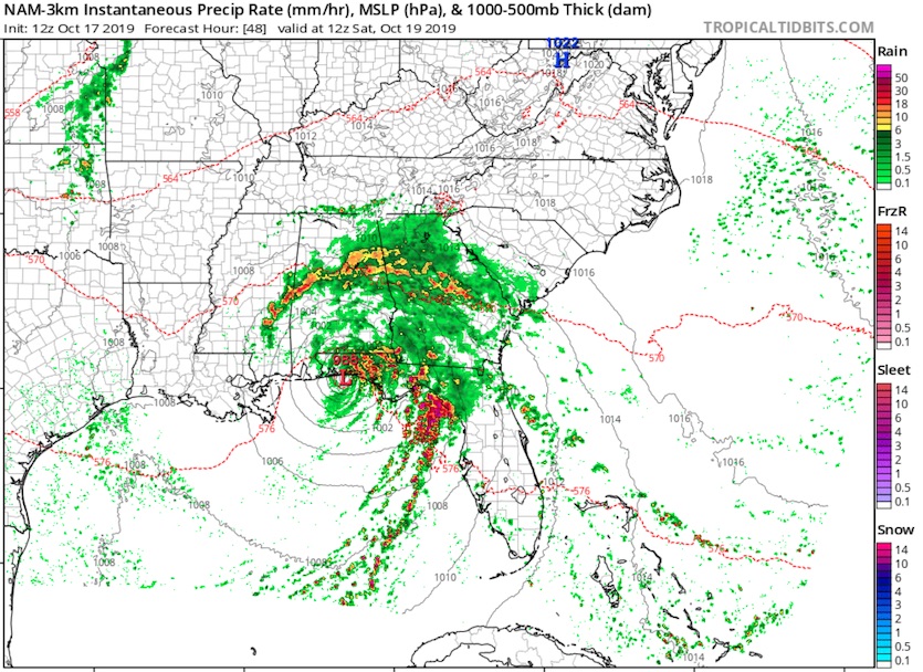
Strong wind shear of 20 – 25 knots is already affecting PTC 16, and it will continue to do so as the system heads northeast at an increasing pace toward the central Gulf Coast. At first, the shear will serve more to ventilate the storm than to quash it, which should allow for some strengthening. An approaching cold front and upper-level trough will also interact with PTC 16. These factors will tend to push the system toward becoming a subtropical rather than a tropical storm. By late Friday, we can expect PTC 16 to take on a comma-shaped structure, with a strong band of convection extending southeastward from its center not unlike a cold front emanating from a midlatitude storm.
 |
| Figure 1. The NAM 3-km forecast from 12Z (8 am EDT) Thursday, October 17, valid at 8 am EDT Saturday, shows a landfalling subtropical or tropical storm with a strong band of thunderstorms extending into the eastern Gulf, poised to sweep into Florida on Saturday. While the NAM is not a model designed specifically for tropical cyclones, it is likely capturing the rough flavor of how convection will be arranged around PTC 16. Please consult the National Hurricane Center for specific guidance on the timing and location of PTC 16’s landfall. Image credit: tropicaltidbits.com. |
Given the likely subtropical structure of PTC 16, and the expected wind shear and unstable air, we may have to contend with severe thunderstorms and tornadoes, especially on Saturday. In its Day 3 severe weather outlook, the NOAA/NWS Storm Prediction Center notes that a tornado threat may evolve for Saturday from northern and central Florida into the coastal Carolinas and Georgia. I wouldn’t be surprised to see the SPC outlooks for Saturday ramping up tomorrow, as model forecasts become more specific on timing and location.
In the satellite era (since 1966), ~30% of all Atlantic storms being named this late in the calendar year have originated as subtropical storms. #96L #hurricane pic.twitter.com/otxh6uG71v
— Philip Klotzbach (@philklotzbach) October 17, 2019
Unusually warm waters will help fuel PTC 16
Tropical/subtropical storms are unusual in the western Gulf this late in the year. Only a few such systems are on record for October in the NOAA Historical Hurricanes database (based on HURDAT2), which extends back to 1851. The most recent named storm to develop this late in the western Gulf was Juan (1985), as noted by Phil Klotzbach (Colorado State University). By this time of year, wind shear tends to be increasing, and several cold fronts have often reached the Gulf, cooling the surface waters.
This autumn, though, cool air has made little headway into the western Gulf. Sea surface temperatures across the northwest Gulf were at record-warm levels in September, according to NOAA’s monthly climate report. SSTs along PTC 15’s path are still running 1-2°C (1.8-3.6°F) above average, which means the conditions are more similar to the climatological norm of peak season (August-September) than to the average for mid-October. The unusually warm water may help PTC 16 generate widespread strong convection.
 |
| Figure 2. Departures from the seasonal average sea surface temperature, in degrees Celsius, as of 6Z (2 am EDT) Thursday, October 17, 2019. Image credit: tropicaltidbits.com. |
The prevailing wind shear, the lack of a well-defined, symmetric center, and the relatively short time before landfall will likely keep PTC 16 shy of hurricane strength. None of the 70 ensemble members of the European and GFS model runs from 0Z Thursday make PTC 16 a hurricane, and nearly all predict a weak to moderate-strength tropical or subtropical storm.
Floridians on the Gulf coast need to be ready for storm surge
Storm surge from PTC 16 will be focused well east of the center, as tropical-storm-force winds shoot out over a broad area. Update (5 pm EDT): a storm surge warning is now in effect from Indian Pass to Clearwater Beach, Florida.
Because of PTC 16’s large wind field, and the concave geometry of this stretch of coastline, storm surge could be larger and more widespread than one might typically expect from a tropical or subtropical storm. NHC warns that inundations above ground level could reach 3 – 5 feet from Indian Pass to Chassahowitzka and 2 – 4 feet southward to Clearwater Beach, near Tampa.
 |
| Figure 3. Predicted 5-day rainfall for the period from 12Z (8 am EDT) Thursday, October 17, 2019, through 12Z Tuesday, October 22. Image credit: NOAA/NWS/WPC. |
A heavy rainer, but a fast mover
PTC 16 will dump heavy rains across the central Gulf Coast this weekend. However, the system’s relatively speedy motion will limit total accumulations. Storm totals of 1-3”, with localized totals of 5” or more, will extend from far southeast Louisiana to Florida’s Gulf Coast, perhaps as far east and south as Tampa. Rains of 1-2” will affect many areas well inland.
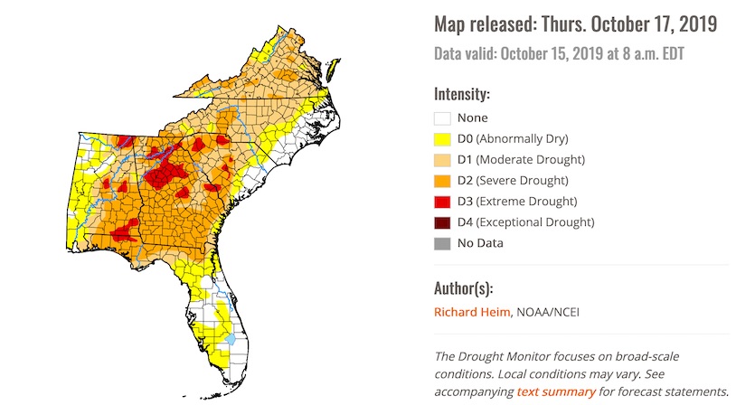
The rains from PTC 16 will be largely beneficial given the flash drought that’s affected the Southeast in recent weeks. As of Thursday’s weekly U.S. Drought Monitor, based on data through 8 am Tuesday, drought conditions were affecting 84% of the Southeast. Severe to exceptional drought covered 35% of the region—a jump from 23% just one week earlier. (Note that the round of soaking rain affecting the Southeast on Tuesday has almost certainly reduced the drought extent from what is shown below.)
 |
| Figure 4. The weekly U.S. Drought Monitor released Thursday, October 17, 2019—based on data through October 15—showed severe to exceptional drought (levels D2-D4) covering large parts of the Southeast. Image credit: National Drought Mitigation Center. |


