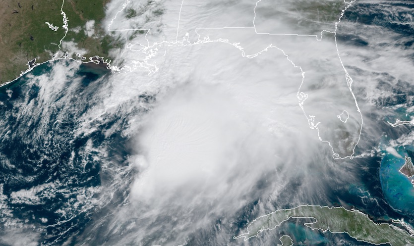
| Above: Infrared satellite image of Potential Tropical Cyclone 16 at 1651Z (12:51 pm EDT) Friday, October 18, 2019. Image credit: NASA/MSFC Earth Science Branch. |
Update: After more than a day as Potential Tropical Cyclone 16, a system moving through the Gulf of Mexico became Tropical Storm Nestor at 2 pm EDT Friday, heading toward an expected landfall early Saturday along the Florida Gulf Coast. Nestor could deliver a significant storm surge, very heavy rain, and the potential for severe weather, including tornadoes. The discussion below was published just before PTC 16 became Nestor at 2 pm EDT. We'll have a full update on Nestor later today.
At 11 am EDT Friday, PTC 16 was centered about 400 miles southwest of Panama City, Florida. “Center” is a matter of judgment, as the system’s core was an elongated zone of low pressure rather than a more symmetric cyclone. Moreover, the heaviest showers and thunderstorms (convection) are clustered to the east of the surface center. For these reasons, the National Hurricane Center held off on classifying PTC 16 as a subtropical or tropical storm. Nevertheless, a Hurricane Hunter flight late Friday morning found winds of 83 mph at flight level, and surface winds were estimated as high as 60 mph based on SFMR (stepped frequency microwave radiometer) data.
 |
| Figure 1. GeoColor satellite image of Potential Tropical Cyclone 16 at 1630Z (12:30 pm EDT) Friday, October 17, 2019. Image credit: RAMMB/CIRA/CSU. |
NHC predicts that PTC 16 could intensify slightly on Friday afternoon or evening, as an upper-level trough injects energy. There is still time for the system to develop a more consolidated center, in which case PTC 16 would become Subtropical or Tropical Storm Nestor (more likely the former, given its asymmetric nature). Models are in close agreement on PTC 16 accelerating northeastward and making landfall in the Florida Panhandle early Saturday morning, perhaps in the predawn hours.
The most concentrated impacts from PTC 16 will be on its east side, mainly affecting the Gulf coast of Florida. The intensifying complex of thunderstorms will roll into northern and central Florida late Friday into Saturday, likely with torrential rain and high winds associated with the surface cyclone as well as with thunderstorm downdrafts. Mini-supercells could develop, especially on Saturday, and these will have the potential to produce mostly short-lived tornadoes.
Storm surge a key threat with PTC 16
Significant storm surge is possible with PTC 16 as far south as the Tampa area, whether or not the system gets named before landfall. A storm surge warning is in effect from Indian Pass to Clearwater Beach, Florida. Water levels were running about a foot above normal across this area at midday Friday. Depending on the timing of landfall with respect to high tide, inundations above ground level could reach the following values:
Indian Pass FL to Chassahowitzka FL...3 to 5 ft
Chassahowitzka to Clearwater Beach FL...2 to 4 ft
Tampa Bay...1 to 3 ft
The highest water from PTC 16 may occur close to the early-morning high tides, which arrive around 2 am at Clearwater Beach, around 5 am at Cedar Key, and around 6 am at Apalachicola.
 |
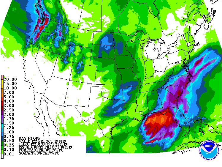
| Figure 1. Predicted 3-day rainfall for the period from 12Z (8 am EDT) Friday, October 18, 2019, through 12Z Monday, October 21. Image credit: NOAA/NWS/WPC. |
PTC 16 will dump heavy rain along its path, especially across northern Florida, where localized totals could exceed 5”. Widespread totals of 1” – 3” can be expected as PTC 16 races across southern Georgia, South Carolina, and eastern North Carolina. Flooding concerns are relatively low with this system, given its rapid motion and the relatively dry conditions that have predominated in recent weeks, but flash floods are always a threat with high rainfall rates in a landfalling system like this one.
We’ll have an update on PTC 16 later today.


