| Above: Infrared satellite image of ex-Tropical Storm Beryl at 9:06 pm EDT July 8, 2018. Ex-Beryl was generating a very intense thunderstorm near Guadeloupe in the Leeward Islands. Image credit: Levi Cowan, tropicaltidbits.com. |
Tropical Storm Beryl degenerated to a very windy and rainy tropical wave on Sunday afternoon, as it sped west-northwest through the Leeward Islands at 26 mph. Strong upper-level winds out of the west, along with Beryl’s rapid forward motion, brought high wind shear of 20 knots to the storm that drove dry air into its core, destroying its surface circulation. Beryl lasted as a named storm for three days.
 |
| Figure 1. Radar image of the remnants of Beryl at 10 pm AST July 8, 2018, from the Guadaloupe radar. A band of heavy thunderstorms was over the island. Image credit: Meteo France. |
Beryl brought strong winds and heavy rains to Guadeloupe in the Leeward Islands overnight, with La Desirade Island reporting a wind gust of 48 mph at 9 pm AST Sunday. Twenty-four-hour rain amounts ending at 8 am AST Monday for some Guadeloupe stations included:
Ste Rose Viard: 5.73” (145.5 mm)
Le Moule Laureal: 4.13” (105 mm)
Basse Terre: 3.21” (81.5 mm)
There are no reports of serious damage or injuries from Beryl’s passage through the Leeward Islands, but Guadeloupe probably experienced localized flash flooding problems.
 |
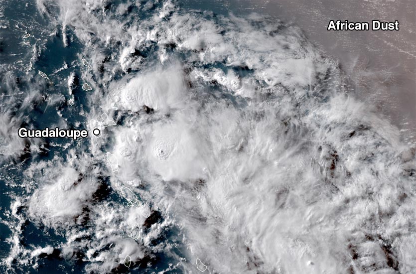
Figure 2. Visible satellite image of Tropical Storm Beryl at 5 pm EDT July 8, 2018, when NHC issued their final advisory on the tropical storm, as it neared Guadeloupe in the Leeward Islands. Image credit: Levi Cowan, tropicaltidbits.com. |
Ex-Beryl impacting Puerto Rico and the Virgin Islands
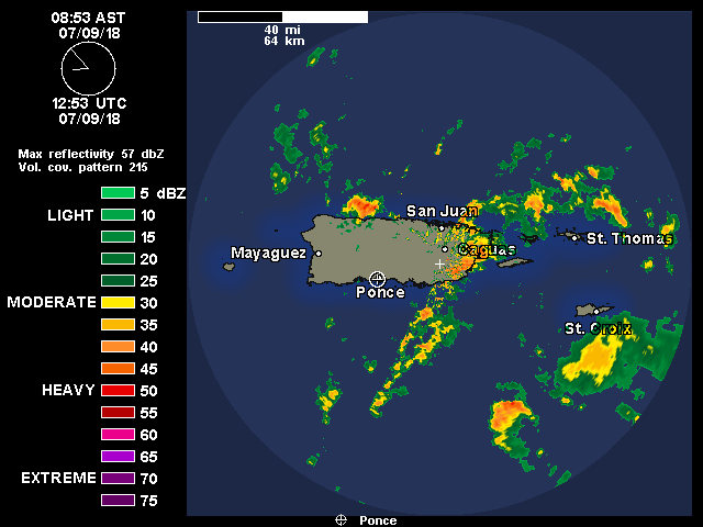
A Flash Flood Watch was posted for most of Puerto Rico and the U.S. Virgin Islands on Monday morning, for 2 – 4” of rain with locally higher amounts. Weather radar and satellite images showed that ex-Beryl was centered near St. Croix in the Virgin Islands at 9 am EDT Monday, and was bringing bands of heavy thunderstorms that were affecting Puerto Rico, the Virgin Islands, and most of the Leeward Islands. Wind gusts of 40 – 50 mph are expected from these storms, along with torrential rain.
 |
| Figure 3. Radar image of the remnants of Beryl at 8:53 am AST July 9, 2018, from the Puerto Rico radar. Ex-Beryl was bringing heavy rains to much of Puerto Rico and the Virgin Islands. |
Forecast for Beryl’s remnants
The ridge of high pressure steering Beryl’s remains will take it over the Virgin Islands and Puerto Rico on Monday, and across Hispaniola on Monday night. The remnants of Beryl have the potential to bring heavy rains of 2 – 4” to these areas. Ex-Beryl will traverse the mountainous island of Hispaniola on Tuesday, which will disrupt the organization of the storm. By Wednesday, when ex-Beryl will be moving northwards over the central Bahamas and the waters to the northeast of those islands, the system will potentially begin to re-organize into a tropical depression. SSTs will be near 28.5°C (83°F), the SHIPS model predicts that wind shear will be a light to moderate 5 - 15 knots, and an upper-level anticyclone may be present aloft to help provide upper-level outflow. All these conditions are favorable for development, and in their 8 am EDT Monday Tropical Weather Outlook, the National Hurricane Center gave ex-Beryl 2-day and 5-day odds of regeneration of 0% and 40%, respectively.
We'll have a new post on Tropical Storm Chris and Super Typhoon Maria later today.


