| Above: GOES-16 satellite image of Subttrpiocal Storm Oscar feeling lonely out in the central Atlantic, far from any land areas, at 11 am EDT October 27, 2018. Image credit: NOAA/RAMMB. |
Subtropical Storm Oscar formed in the waters of the central Atlantic on Friday night, and is expected to stay well out to sea, far from any land areas. Oscar had marginal SSTs to work with on Saturday, near 26.5°C (80°F), but moderate wind shear around 10 knots allowed the subtropical storm intensify, reaching top winds of 60 mph by 11 am Saturday.
Satellite images on Saturday showed that Oscar was subtropical in nature, with the heaviest thunderstorms located in a band well removed from the center. However, the subtropical storm was gradually becoming more tropical, building heavy thunderstorms near its core. By Sunday, Oscar should be fully tropical, and has a chance of reaching Category 1 hurricane strength before recurving to the northeast on Tuesday.
For the first time on record (since 1970), all Northern Hemisphere tropical cyclone basins (North Atlantic, NW Pacific, NE Pacific and North Indian) will have above-average seasonal values of Accumulated Cyclone Energy in 2018. #Yutu #hurricane #typhoon pic.twitter.com/rNg9QAo19D
— Philip Klotzbach (@philklotzbach) October 26, 2018
An active 2018 Atlantic hurricane season
Oscar’s formation brings the 2018 tally of activity in the Atlantic to 15 named storms, 7 hurricanes, 2 intense hurricanes, and an Accumulated Cyclone Energy (ACE) index of 121. The 1981 – 2010 averages for the entire season were 12.1 named storms, 6.4 hurricanes, 2.8 intense hurricanes, and an ACE of 105.6. The 15 named storms this year puts 2018 in the upper 15% for the most named storms in an Atlantic season. In records going back to 1851, only 22 out of 168 seasons have had 15 named storms or more (including 2018). The top spots are held by 2005 and 1933, which had 28 and 20 named storms, respectively. However, prior to the satellite era, many short-lived tropical storms that formed far from land missed detection, so it is more relevant to look at stats since the satellite era began in 1970. Since 1970, 14 of 49 seasons have had 15 or more named storms (including 2018), so this year ranks in the top 30% of seasons for total number of named storms since 1970.
Oscar is the 7th Atlantic named storm to be classified as subtropical at some point during its lifetime--the most Atlantic subtropical storms in a season on record. The prior record was 5 in 1969, according to Dr. Phil Klotzbach. As explained in our WU backgrounder on subtropical storms, NHC began classifying subtropical storms in 1968, but they did not start assigning them names until 2002. You might think one reason 2018 was able to rack up so many named storms is because each of this year's subtropical storms got a name. However, all of this year's subtropical storms were also tropical cyclones at some point over the open ocean. This includes Alberto, which was originally classified as subtropical throughout its track across the Gulf of Mexico. In its final report on Alberto, issued October 18, NHC concluded that Alberto was actually a tropical storm over the northern Gulf. (Thanks to Cat 6 reader elioe for calling this report to our attention.)
 |
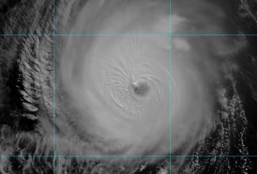
| Figure 1. VIIRS day-night satellite image of Super Typhoon Yutu at 0447Z (12:47 am EDT) Saturday, October 27, 2018. Image credit: RAMMB/CIRA/CSU. |
Yutu headed for the Northern Philippines
Still a Category 4 super typhoon with 150 mph winds as of 11 am EDT Saturday, former Category 5 Yutu continued rolling westward on a course toward the Philippines island of Luzon, home to more than 50 million people. Model guidance is now in close-to-unanimous agreement that Yutu’s track will bend slightly toward the west-southwest over the next several days, which would take Yutu across central or northern Luzon on Tuesday local time.
Mesmorizing IR loop of Super Typhoon #Yutu with amazing gravity waves pulsating outward around the eye. So powerful! HT @CIMSS_Satellite https://t.co/wvt9z9gbqy pic.twitter.com/R2Aae3RRpY
— UW-Madison CIMSS (@UWCIMSS) October 27, 2018
Yutu was slightly less organized than on Friday, but it remained a formidable cyclone, with an intense convective core, a distinct eye, and plenty of upper-level ventilation through outflow jets, especially to the northwest. Working against Yutu this weekend was a zone of 20 – 25 knots of wind shear, which was pushing drier air into the typhoon’s environment.
The Joint Typhoon Warning Center (JTWC) predicted that Yutu would weaken to Category 3 strength by Monday local time. By that point, the wind shear is predicted to become quite light (less than 10 knots). Moreover, Yutu will be passing over a patch of ocean with very high heat content (see Figure 2), ranging from 75 to more than 100 kilojoules per square centimeter. The JTWC forecast gradually weakens Yutu up to a predicted landfall as a lower-end Cat 3 storm, but it wouldn’t be a shock to see Yutu holding its own or even reintensifying a bit on Monday prior to landfall. The 12Z Saturday run of the HWRF model brought Yutu to the coast as a Category 4 typhoon.
 |
| Figure 2. Oceanic heat content over the Northwest Pacific as of 12Z (8 am EDT) Saturday, October 27, 2018. Yutu will pass over a pocket of very deep warm water from Sunday into Monday, just before it reaches the Philippines. Image credit: RAMMB/CIRA/CSU. |
Bob Henson wrote the Yutu section of this post.


