| Above: GeoColor satellite image of Tropical Storm Nestor at 21Z (5 pm EDT) Friday, October 18, 2019. Image credit: RAMMB/CIRA/CSU. |
Tropical Storm Nestor was speeding toward Florida’s Gulf Coast on Friday night, with landfall expected early Saturday. This highly asymmetric storm will bring a variety of impacts to the Southeast U.S., especially northern parts of Florida, ranging from storm surge and torrential rain to localized high winds and a tornado threat.
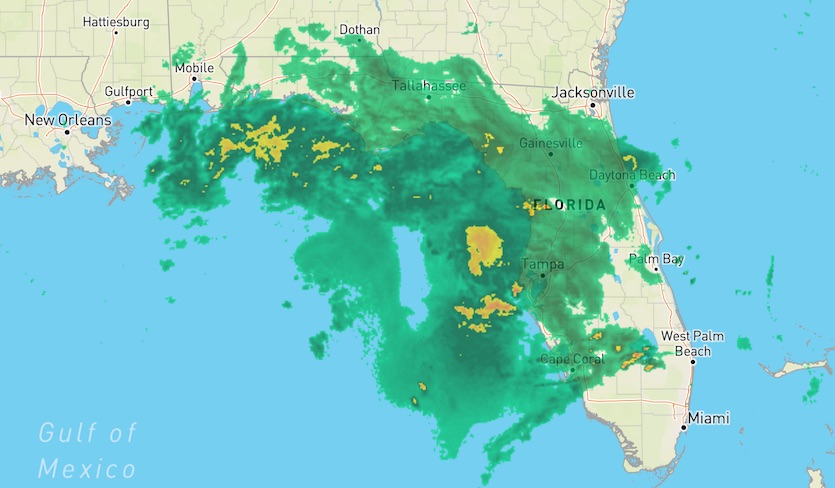
Nestor was packing 60-mph sustained winds as of 8 pm EDT Friday. Centered about 215 miles southwest of Panama City, Florida, the storm was racing northeastward at 22 mph. Almost all of Nestor’s tropical storm–force winds were occurring on its east and south sides, and the heaviest thunderstorm activity (convection) was also located well east of the center. Impacts should be comparatively modest to the west of Nestor’s center. A tropical storm warning is in effect from Navarre to Yankeetown, Florida.
Nestor’s lopsided structure is partly the result of an upper-level trough impinging on the storm. The trough is leading to upper-level wind shear that favors intense convection but displaces it east of the center, in much the same way that thunderstorms can get pushed well ahead of a midlatitude cold front. Subtropical storms often exhibit this structure, but Nestor is still classified as tropical for now.
Nestor is benefitting from unusually warm sea surface temperatures. SSTs across the northwest Gulf were at record-warm levels in September, according to NOAA’s monthly climate report. SSTs along Nestor’s path have been running 1-2°C (1.8-3.6°F) above average, which means the conditions are more similar to the climatological norm of peak season (August-September) than to the average for mid-October.
 |
| Figure 1. WU composite of National Weather Service radar showing extensive showers and thunderstorms over the northeast Gulf associated with Nestor at 2347Z (7:47 pm EDT) Friday, October 18, 2019. |
Outlook for Nestor
Strong thunderstorms were heading toward the Tampa area on Friday evening. These could arrive with very heavy rain and strong downdraft winds, perhaps reaching severe levels. Additional storms will push across central and northern Florida later tonight. Tornadoes will be possible, especially near Florida's Gulf coast and inland toward Lake Okeechobee.
A period of more sustained tropical-storm-force southwest winds can be expected along Florida’s Big Bend coast early Saturday, as Nestor’s center approaches the coast.
The core of strongest winds in Nestor could intensify slightly tonight, but the storm is not expected to become a hurricane before it pushes ashore. Regardless of strength or status, it’s unusual for any NHC-named cyclone to make a U.S. landfall so late in the year. The last hurricane and tropical storm to make a U.S. landfall this late were Hurricane Wilma (2005) and Tropical Storm Mitch (1998), respectively, as noted by Phil Klotzbach (Colorado State University). Sandy struck the mid-Atlantic on October 29, 2012, but that hurricane was reclassified as post-tropical just before it made landfall in New Jersey.
Nestor will quickly evolve into a post-tropical cyclone on Saturday. It’s expected to move on a track just inland, from southern Georgia on Saturday afternoon to eastern North Carolina on Sunday. Nestor will then move back offshore into the Atlantic, but strong wind shear should keep it from regrouping before it dissipates.
Yet another eerie #face, this one in #PTC16 (now #Nestor) -- I swear there's gotta be something about the convective structure of tropical cyclones (or in today's case semi-tropical) which lends itself to such appearances pic.twitter.com/PkVyToPmKd
— Stu Ostro (@StuOstro) October 18, 2019
Storm surge a key threat with Nestor
The strong surface winds pushing onshore with Nestor could trigger significant storm surge late Friday into Saturday morning into Florida’s surge-prone, sparsely populated Big Bend coastline, perhaps extending as far south as the Tampa area. A storm surge warning is in effect from Indian Pass to Clearwater Beach, Florida. Water levels were running 0.5’ to 1.5’ above normal across this area around sunset Friday.
Depending on the timing of landfall with respect to high tide, inundations above ground level could reach the following values:
Indian Pass FL to Chassahowitzka FL...3 to 5 ft
Chassahowitzka to Clearwater Beach FL...2 to 4 ft
Tampa Bay...1 to 3 ft
The highest water from Nestor may occur close to the early-morning high tides Saturday. These will arrive around 2 am at Clearwater Beach, around 5 am at Cedar Key, and around 6 am at Apalachicola.
Severe weather potential with Nestor
Southeast surface winds are pulling warm, moist air across the southern half of Florida ahead of Nestor. The peninsula is bisected by a warm front separating this air mass from cooler, drier air to the north. As Nestor approaches, it will tend to pull this front northward, allowing for unstable conditions to spread north as well.
Computer models indicate that a cluster or line of strong to severe thunderstorms will likely push into northern Florida on Saturday morning. Tornadoes would be possible within this area, as well as in other thunderstorms and squall lines forming just to the east and northeast of Nestor as the storm tracks inland. The severe threat could extend well into Saturday night over parts of South Carolina and coastal North Carolina.
 |
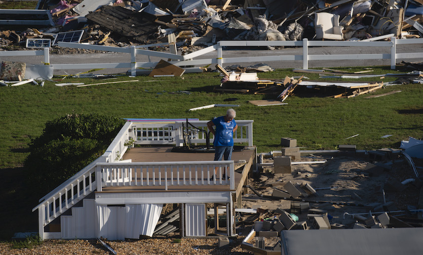
| Figure 2. Tornado damage associated with Hurricane Dorian is seen at the Boardwalk RV Park in Emerald Park, North Carolina, on Saturday, September 7, 2019, the day after Hurricane Dorian passed through the area. Image credit: Elijah Nouvelage for The Washington Post via Getty Images) |
Landfalling tropical cyclones often lead to an increased tornado threat. As a tropical cyclone moves onshore, friction over land causes the surface winds to angle more toward the storm center. These angled surface winds lead to more vertical wind shear (the change in wind direction and speed at different heights) in a way that favors rotating thunderstorms. Such tornadoes often develop from “mini-supercells” that form along rainbands. Although these tornadoes are often short-lived, they can be quite damaging. When Hurricane Dorian made landfall in North Carolina last month, an EF2 tornado damaged or destroyed dozens of trailers and manufactured homes in Emerald Isle, North Carolina. Dorian led to a total of 35 preliminary tornado reports in the Carolinas on September 4-6, according to SPC.
Rainfall from Nestor
Torrential rains are likely with Nestor’s strongest convection, especially in Florida, with localized 5” totals possible. Widespread 1” – 2” amounts can be expected as the storm moves across the Southeast. Because the region has been suffering from drought in recent weeks, the rains from fast-moving Nestor could trigger localized flash flooding but are unlikely to prompt more widespread river flooding.


