| Above: Floodwaters in Sacramento, California along K Street looking west from 4th Street in January 1862 (California State Library, DWR). |
The odds of a 1-in-200-year flood in California costing nearly $1 trillion (4% of U.S. GDP) are steadily rising due to climate change, with a greater than 50% chance of one occurring in the next 40 years. That’s the startling conclusion of a paper (open access) published in 2018 by a team led by Daniel Swain (University of California, Los Angeles, press release here). One dramatic example of the type of damage such a storm could potentially cause is the failure of the Whittier Narrows Dam on the San Gabriel River in the Los Angeles metro area, which could flood up to 1 million people in the metropolitan Los Angeles area.
 |
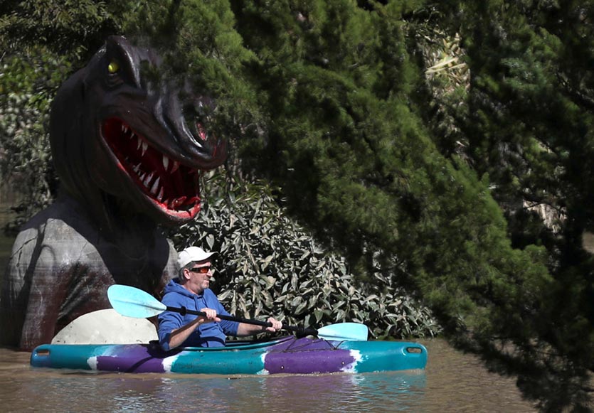
| Figure 1. A kayaker paddles through a Pee Wee golf course in a flooded neighborhood on February 28, 2019 in Guerneville, California. A Category 3 atmospheric river (AR) impacted California February 25 – 27, 2019, dumping a 3-day rainfall amount of 21.36” at Venado. The Russian River rose to major flood stage in Guerneville, where over 2000 buildings flooded. (Photo by Justin Sullivan/Getty Images). |
Storms capable of causing a $1 trillion flood in California have hit multiple times in the past, so it is only a matter of time before one occurs again. The most recent one occurred back in the winter of 1861 – 1862. A 45-day period of torrential rains from multiple storms carrying a strong “atmospheric river” (AR) of tropical moisture impacted the state, turning California’s Central Valley into a lake 300 miles long and over 20 miles wide. The resulting floods put downtown Sacramento under 10+ feet of water, forcing movement of the state capital to San Francisco. Sediment research has found that six storms even more severe than the 1861 – 1862 storm hit California in the years 212, 440, 603, 1029, 1418, and 1605 AD.
If a storm with an equivalent amount of precipitation were to hit California now, it might do $900 billion (2019 dollars) in damage, according to a 2011 study by the USGS called the “ARkStorm Scenario” (the “AR” stands for Atmospheric River, and the “k” stands for the number one thousand, since the storm could be expected to bring 1-in-1000-year rains to some locations). The storm they modeled could flood up to 25% of all buildings in the state, breach approximately 50 levees, and force the evacuation of 1.5 million people.
 |
| Figure 2. Areas of California expected to flood (colored blue) under the 2011 “ARkStorm Scenario” modeled by the USGS. |
Since there is very little data on the meteorological conditions prevailing at the time of the 1861 – 1862 storm, the USGS ArkStorm scenario used a computer-modeled hybrid storm that combined two actual storms that hit California (a Southern California storm from January 19-27, 1969, followed by a northern California storm from February 8-20, 1986, with an additional tweak to produce a sufficient amount of precipitation to approximately match the limited observations of 1861 - 1862). The USGS ARkStorm did $725 billion (2007 dollars) in damage, which is $900 billion in 2019 dollars (4% of U.S. GDP). About 55% of the damage was to buildings, infrastructure, and agriculture, while 45% was due to business interruption. They cautioned that these impacts were not exhaustive, since they did not consider tourism and recreation, or loss of cultural value as a result of damage to historic artifacts and sites. Thus, damages from an ARkStorm could easily reach the $1 trillion threshold--particularly if a repeat of one of the six stronger storms documented in the past 2000 years were to hit.
 |
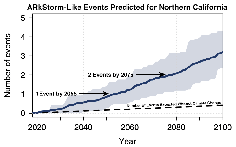
| Figure 3. Average number of ARkStorm-like events predicted under a business-as-usual emissions scenario (RCP8.5, thick blue line) by 40 climate simulations from the NCAR Community Earth System Model, along with the number expected in the climate from pre-industrial times (dashed line). The light blue shaded area represents the number of ARkStormo-level events predicted in each year by two-thirds of the model runs. Image credit: Swain et al., 2018, Increasing precipitation volatility in twenty-first century California, Nature Climate Change. |
A warmer climate will lead to stronger atmospheric rivers hitting California
The recently released Fourth National Climate Assessment states, “The frequency and severity of landfalling ‘atmospheric rivers’ on the U.S. West Coast … will increase as a result of increasing evaporation and resulting higher atmospheric water vapor that occurs with increasing temperature. (Medium confidence).” The 2018 study led by Swain obtained the same result. They used the NCAR Community Earth System Model to simulate California’s climate in the high-emissions or “business as usual” scenario (RCP8.5, the path humanity is currently on). The model showed that a steadily warmer climate can be expected to make rare 1-in-200-year ARkStorms occur once every 40 or 50 years. The authors wrote, “Strikingly, these findings suggest that California’s major urban centers (including San Francisco and Los Angeles) are more likely than not to experience at least one such extremely severe storm sequence between 2018 and 2060 on a business-as-usual emissions trajectory." That means multiple $1 trillion floods will probably happen in California in coming decades--unless major upgrades to the state's flood-control infrastructure are performed.
Swain said the likelihood of an 1862-style megaflood “goes from extraordinarily rare to just very unusual, and that’s a very big problem. We haven’t built any of our infrastructure to accommodate an event like [the flood of] 1861-82, even though we know it can happen, because it already did.”
 |
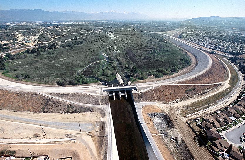
| Figure 4. The Whittier Narrows Dam on the San Gabriel River in the Los Angeles metro area. Image credit: U.S. Army Corps of Engineers. |
The Whittier Narrows Dam in Los Angeles at high risk of failure from an ARkStorm
One sobering example of the vulnerability of California’s infrastructure to an ARkStorm is the potential failure of the Whittier Narrows Dam on the San Gabriel River in the Los Angeles metro area. In an article published in the Los Angeles Times in February, Swain said that the Whittier Narrows Dam is “one of the many pieces of water infrastructure that may not be up to the challenge of the brave new climate of the 21st century.” Up to 1 million people in metropolitan Los Angeles could be flooded by a failure of the dam, with the highest water levels of 20’ affecting Pico Rivera, a city of 63,000 that lies just downstream.
According to the Whittier Daily News, the 62-year-old earthen dam was rated as the highest priority dam to fix of the 13 dams nationwide rated as “high risk” by the Army Corps of Engineers, due to the potential for “very significant loss of life and economic impacts.” However, the dam is the only one of the 13 high-risk dams that has not yet finalized an upgrade plan, putting it far behind schedule. The Corps performed emergency repair work on the dam’s gates and locks in 2018; this work is expected to continue until completion happens later in 2019. The Army Corps is seeking over $500 million in federal funding to upgrade the 3-mile-long dam, but funding will require congressional approval. The Corps hopes to start construction to upgrade the dam in 2021, with the project likely to take five years.
Related posts
New Study: Precipitation Whiplash is Hitting California, and It’ll Get Worse, our March 2018 post.
California’s ongoing flood control improvements may not be enough to handle an ARkStorm, as reported by Eric Zerkel in weather.com’s “United States of Climate Change” series in 2018. Interviews with experts in the article state that California's Central Valley needs $21 billion in improvements, and the state as a whole needs $80 billion, in order to reach the current flood protection standard: a 1-in-200-year flood. This will not protect against an ARkStorm, which is being called 1-in-500-year protection. That level of protection would require another $21 billion investment. Note that according to Swain's research, a 1-in-500-year flood will be more like a 1-in-50-year flood by 2060, if we continue down our current greenhouse gas emissions trajectory.
WU weather historian Christopher Burt has a post with meteorological background on California’s Great Flood of 1862.
The Los Angeles Times investigated the risks of catastrophic California flooding in a report on March 25, 2018.
Bob Henson contributed to this post.


