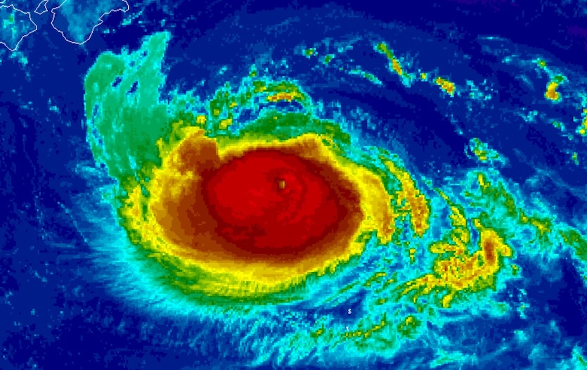
| Above: GeoColor visible satellite image of Hurricane Dorian at 1906Z (3:06 pm EDT) Saturday, September 7, 2019. Image credit: NOAA/NESDIS. |
After terrorizing the Northwest Bahamas and strafing the Southeast U.S. coast, Hurricane Dorian was hurtling on Saturday toward an encounter with far eastern Canada. Dorian was on track to reach Nova Scotia on Saturday night, coming ashore close to Halifax as a hurricane or a powerful post-tropical storm. Even as the latter, Dorian may bring hurricane-force winds to far western Newfoundland and brush far southeast Labrador early Sunday. Dorian also pushed heavy surf toward the New England coast.
Crazy ride on 44011 (170 nm east of Hyannis, #mawx) this morning! Waves of 39 feet as #Dorian passes. That's taller than a 3-story building! pic.twitter.com/xyqEOPp7ya
— Greg Carbin (@GCarbin) September 7, 2019
Strong upper-level winds were ripping Dorian’s convection (showers and thunderstorms) toward the north and northeast of its center at midday Saturday. Even so, the hurricane was packing a large swath of intense winds to its south and southwest, likely being goosed by interactions with the midlatitude jet stream. Hurricane-force sustained winds extended out to 105 miles, and tropical-storm-force winds up to 310 miles. Top winds were back up to 100 mph at 2 pm EDT, making Dorian a Category 2 hurricane yet again, and the central pressure was down to 953 mb.
Canada is no stranger to seeing Category 1 winds from hurricanes (or their extratropical versions, since many hurricanes transform to powerful extratropical storms with hurricane-force winds shortly before reaching Canada). Such storms rarely arrive at Category 2 strength, though, and Dorian’s winds could wreak havoc on a wide swath of central and eastern Nova Scotia. As explained in our Friday post, the timing of Dorian’s strike on the coast is critical for determining how much storm surge damage occurs, since the range between low tide and high tide is about 1.5 meters in Nova Scotia. If Dorian hits near low tide, which occurs at 10:50 pm ADT Saturday, there will be little or no storm surge damage. But if the hurricane hits at high tide (3:25 pm ADT Saturday), surge damage could be significant. Right now it appears landfall and the strongest winds will arrive in the decreasing half of the tidal cycle.
Only two hurricanes have had their names retired because of Canadian impacts. Hurricane Juan of 2003 took a worst-case track and hit Halifax as a Category 2 hurricane with 100 mph winds, killing 8 and causing $200 million (2003 USD) in damage. Juan is Canada’s most expensive hurricane on record. Hurricane Igor of 2010 brought catastrophic flooding to Newfoundland, where it dumped up to ten inches of rain. Igor’s price tag was $200 million (2010 USD).
FYI: #Dorian is far from finished. NHC has upgraded back to a 100 mph storm (Category 2) as it heads towards landfall in Nova Scotia, #Canada. This may lead to notable damage; especially to infrastructure. pic.twitter.com/uraZ3TIAn8
— Steve Bowen (@SteveBowenWx) September 7, 2019
According to the NOAA Historical Hurricane Tracks website, ten Category 1 and four Category 2 storms have made landfall in Canada since records began in 1851 while still being classified as hurricanes. Aside from Juan, the other Category 2 storms are:
—Hurricane Ginny of 1963, which made landfall in southwestern Nova Scotia as a Category 2 storm with 105 mph winds.
—Hurricane Gerda of 1969, which crossed into New Brunswick as a Category 2 hurricane with 105 mph winds after making landfall in eastern Maine.
—Hurricane Michael of 2000, which made landfall in Newfoundland as a Category 2 storm with 100 mph winds.
 |
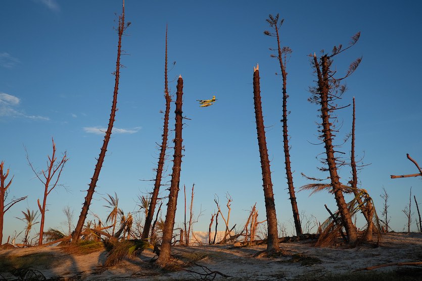
| Figure 1. A relief plane departs on Friday, September 6, 2019, in Elbow Key Island, Bahamas. Image credit: Jose Jimenez/Getty Images. |
Dorian’s U.S. impacts
Horrific scenes from Dorian continue to emerge from the Northwest Bahamas, where Great Abaco and Grand Bahama islands took massive hits. The death toll had risen to 43 by midday Saturday, according to weather.com, and the toll is likely to rise substantially as search and rescue teams reach some of the hardest-hit areas. "Let me say that I believe the number will be staggering," Minister of Health Duane Sands said, according to the Nassau Guardian.
In contrast, Dorian barely made landfall in the United States—the center passed over Hatteras Island on its way back to the open Atlantic at 8:35 am EDT—and the storm’s stronger right-hand side avoided the Southeast coast entirely.
And there it is.
— Dakota Smith (@weatherdak) September 6, 2019
Nearly two weeks since forming, Dorian makes landfall in the U.S.
Cape Hatteras, NC. pic.twitter.com/HRBYgBJCRL
Dorian brought 25 tornado reports, widespread power outages (400,000 customers in North Carolina alone), and scattered flash flooding, but rainfall totals and storm surge peaks were largely below expectations. The most frightening outcome was the pulse of storm surge that swept around the north side of Dorian from Pamlico Sound as Dorian passed by. Water levels rose about seven feet in just 90 minutes on Ocracoke Island, swamping the vulnerable island with its worst flooding in decades of memory. Hatteras Island also saw significant flooding from the backside surge.
About 800 people had stayed on Ocracoke, which is accessible only by boat or air, despite mandatory evacuation orders for visitors and residents. Emergency officials have transported "fuel trucks, generators, and food and water" to the island, according to a release from Gov. Roy Cooper's office. Many supplies were being brought in by helicopter.
How high did the water rise in #Ocracoke? The Village Craftsmen have updated the marks on their building: #obx #Dorian #ncwx pic.twitter.com/sAKNL3lL0S
— Sam Walker OBX Today (@SamWalkerOBX) September 7, 2019
 |
| Figure 2. Pedestrians walk in the rain brought by Typhoon Lingling on Saturday, September 07, 2019, in Seoul, South Korea. Image credit: Chung Sung-Jun/Getty Images. |
Lingling slams the Korea Peninsula
Typhoon Lingling came ashore on the southwest coast of North Korea as a minimal-strength typhoon on Saturday afternoon. Formerly a Category 4-strength typhoon, Lingling brought strong winds, heavy rains, and high seas to western and southern parts of South Korea as it raced north through the Yellow Sea. At least 3 deaths and 10 injuries were reported in South Korea, according to weather.com. There were no immediate reports from North Korea of damage or injuries from the storm. A swath of torrential rain was expected in far western North Korea and adjacent parts of China.
 |
| Figure 3. Infrared satellite image of Typhoon Faxai at 1730Z (1:30 pm EDT) Saturday, September 7, 2019. Image credit: CIMSS/SSEC/UM-Madison. |
Fast-strengthening Faxai heads toward Tokyo area
The region around Tokyo may see a grazing blow—or full-on impact—from an intense typhoon late Sunday local time. Typhoon Faxai was at Category 3 strength at midday Saturday after a startling burst of rapid intensification, its top winds having surged from 65 to 120 mph in just 24 hours. Faxai is projected by the Joint Typhoon Warning Center (JTWC) to curve northwest and north before striking near or just east of Tokyo as a Category 3 storm. Some additional strengthening could occur.
Although there is high confidence in the overall track of Faxai, just a slight west or east variation in the track could make a huge difference in Tokyo-area impacts. Torrential rains are a safe bet in any event, and wind and surge impacts could be major if Faxai arcs just west of its JTWC-predicted path. The 12Z HWRF model bring Faxai on a dangerous track making landfall just west of Tokyo, which could drive a major storm surge into Tokyo Bay. The 12Z European and GFS models also take Faxai near or just west of Tokyo.
 |
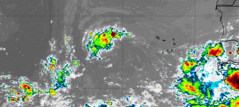
| Figure 4. Infrared satellite image of 94L (center top) at 1904Z (3:04 pm EDT) Saturday, September 7, 2019. Image credit: tropicaltidbits.com. |
A threat to the Lesser Antilles: 94L off the coast of Africa
A tropical wave located at 8 am EDT Saturday about 300 miles west of the Cabo Verde Islands (94L) was headed west at about 12 mph. This system has the potential to be trouble for the Lesser Antilles in about a week.
Satellite images on Saturday afternoon showed that 94L had a high amount of spin, and a modest amount of heavy thunderstorm activity that had increased considerably since Friday. The relatively limited heavy thunderstorm activity was due to dry air, as seen on the latest Saharan Air Layer Analysis.
The 6Z Saturday run of the SHIPS model predicted that the atmosphere in front of 94L would have favorable conditions for development, though, with low wind shear, sea surface temperatures of 28 – 29°C (82 – 84°F), and a mid-level relative humidity near 60%. Dry air will continue to inhibit development over the next two days until 94L can generate enough heavy thunderstorm activity to moisten the atmosphere. The low shear will aid this process.
Despite the overall favorable environment for 94L, dynamical models are generally giving the system a thumbs-down. The 0Z and 6Z Saturday runs of our three top models for predicting tropical cyclone genesis—the GFS, European and UKMET—all showed less support for development than their runs on Friday. Nearly all members of the 0Z ensemble runs of the GFS and European models showed 94L dissipating over the next week, well before it would threaten any land areas.
The wave is predicted to take a track just south of due west over the coming week, and 94L could arrive in the Lesser Antilles Islands as a named storm as early as September 14. However, recurvature into the open central Atlantic is also a good possibility should 94L develop. In their 2 pm EDT Saturday Tropical Weather Outlook, NHC gave this system 2-day and 5-day odds of development of 10% and 50%, respectively—a 20% drop from the odds given on Friday. The next name on the Atlantic list of storms is Humberto.
Elsewhere in the Atlantic, never-say-die Tropical Storm Gabrielle is holding its own after having been reclassified as a post-tropical cyclone at 5 am EDT Friday, then re-reclassified as a tropical storm six hours later. Gabrielle may yet become a minimal hurricane as it traverses the central Atlantic early next week, posing no threat to land.
Dr. Jeff Masters co-wrote this post.


