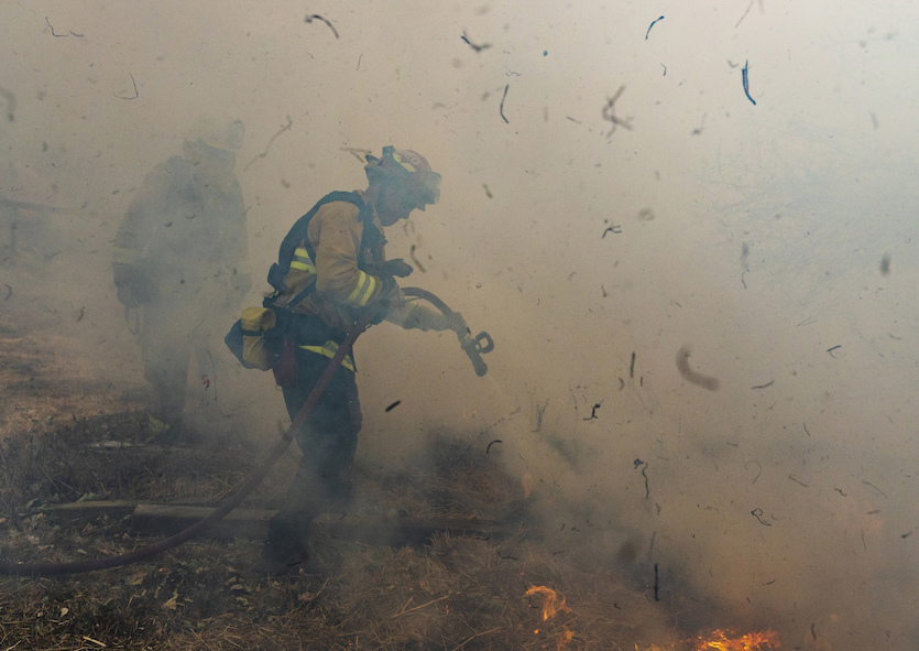
| Above: A firefighter hoses down a smoldering home destroyed by the Getty fire, Monday, Oct. 28, 2019, in Los Angeles, Calif. Image credit: AP Photo/ Christian Monterrosa. |
Yet another siege of fire-stoking weather will sweep across California from Tuesday into Thursday, after a long, grueling weekend of massive evacuations, fast-growing fires, and anxious residents. No fatalities have yet been directly linked to the blazes, but dozens of structures have been lost, and evacuations have affected more than 200,000 people.
After a brief break Monday night, critical fire weather conditions will sweep back into the North Bay region on Tuesday and into Southern California on Tuesday night. Another round of extremely critical fire weather (the highest level of concern) is projected by the NOAA/NWS Storm Prediction Center (SPC) for late Tuesday night into Wednesday and perhaps into early Thursday.
“Recent Santa Ana wind events have continued to cure already critically dry fuels, and this event is likely to be the strongest yet this fall,” warned SPC. “Any new/ongoing wildfires will likely spread rapidly with extreme fire behavior and long-range spotting also possible.”
More than a million California customers have lost power since Saturday—many for days—in the latest in a string of controversial blackouts staged by Pacific Gas & Electric to reduce the chance that utility lines could spark new blazes. Although the “all clear” went out in many areas Monday, new blackouts are expected as soon as Tuesday. Even with the blackouts, PG&E acknowledged on Monday that its lines may have ignited two Bay Area fires.
 |
| Figure 1. Firefighters from San Mateo, California, work to extinguish flames from the Kincade Fire in Sonoma County on Sunday, Oct. 27, 2019. Image credit: AP Photo/Ethan Swope. |
California’s most expansive fire of the last few days is the Kincade Fire, which began near Geyserville on Thursday and worked its way southward toward parts of the North Bay region hard hit by the wildfires of October 2017. As of 9 am PDT Monday, the Kincade Fire had torched some 66,000 acres and was only 5% contained. The fire prompted weekend evacuations across a vast swath of the North Bay region from near Santa Rosa west to the Pacific Ocean. Nearly 80,000 structures were threatened by the fire, according to Cal Fire. Much of the land west of Highway 101 to the coast is covered by dense forests that haven’t burned since at least the 1940s, as reported by the New York Times.
Wow, check out this satellite image from #Sentinel-2
— NWS Bay Area (@NWSBayArea) October 28, 2019
showing the #KincadeFire from ~488 miles up. It should be noted the "fire" colors are not actually visible fire, but infrared signatures. #cawx #cafire script from @Pierre_Markuse pic.twitter.com/LUGdonEKH8
In Los Angeles, the Getty Fire erupted early Monday morning, prompting evacuations of about 3300 homes, many in and near the Brentwood area. Among the celebrities forced from their homes were LeBron James and Arnold Schwarzenegger. As of noon PDT, the fire had affected 618 acres (just under one square mile). The fire’s namesake, the Getty Center museum complex, is well fortified to survive a blaze, but the nearby Interstate 405—the nation’s busiest highway—was closed in the southbound direction on Monday.
 |
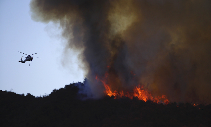
| Figure 2. A helicopter prepares to drop water onto a burning ridge top as the Getty Fire burns on Mandeville Canyon in Los Angeles on Monday, Oct. 28, 2019. Image credit: AP Photo/Marcio Jose Sanchez. |
Firefighters have dogged several other blazes since Thursday. The Tick Fire near Santa Clarita, 75% contained as of Monday morning, consumed about 4600 acres and 29 structures. The Glen Cove and Sky fires flanked the Carquinez Strait northeast of San Francisco, burning less than 200 acres each. See the weather.com roundup for more on these and other blazes.
Thus far, none of the fires this month have approached the level of destruction of the worst California firestorms in recent years. According to Cal Fire, seven of the 10 most destructive fires in California history (each consuming more than 1000 structures) have occurred since 2015. The deadliest and most destructive fire in modern California history was the Camp Fire of November 2018, which decimated the town of Paradise, took 86 lives, and destroyed more than 18,000 structures.
Check out this glimpse of @mrcafiredivision engaged with initial attack of the #OakFire in Calabasas at 101fwy & Las Virgenes Canyon. Fortunately the fire was held to only 10 acres thanks to rapid response from emergency crews and air drops!
— MRCAParks (@MRCAParks) October 28, 2019
What do you think? pic.twitter.com/m2ZNV9zL4Y
Weather that’s too fire-friendly
Autumn is the classic peak of California’s fire season. The state’s Mediterranean climate of mild, wet winters and hot, parched summers means that vegetation grows in the winter and dries out in summer. Before the wet season kicks in, the intensifying jet stream can lead to strong surface pressure contrasts that push blasts of powerful, bone-dry winds toward the coast while vegetation is still dry. Among these are the famed Santa Ana winds of SoCal and the diablo winds of NoCal.
The pressure gradient from late Tuesday into early Thursday between Los Angeles and Daggett is expected to peak at near-record levels of 9-12 millibars, according to SPC. This could lead to hellaciously strong Santa Ana winds, gusting up to 80 mph in the Santa Monica and Los Angeles County mountains and up to 70 mph elsewhere in Los Angeles and Ventura counties. The winds will not only extend to the coast but well offshore; even Catalina Island could experience damage from wind-driven waves, according to NWS/Los Angeles.
This won't be a scorching-hot Santa Ana, as the air mass pouring into the western U.S. is extremely cold for late October. Denver is experiencing several days below freezing, and the city may challenge its all-time record low for October of -2°F on Thursday morning.
As all this unfolds, the 2019-20 wet season is dragging its heels getting to California. The Los Angeles and San Francisco international airports haven't had even a sprinkle of rain so far this month. It’s the first time SFO has gone through October without even a trace (airport records go back to 1945) and only the third time LAX has been completely dry in October (airport records go back to 1944). There’s no sign of any measurable rain ahead through at least the start of November, and longer-range outlooks indicate the storm track will stay mainly north of California for the first week of the month.
 |
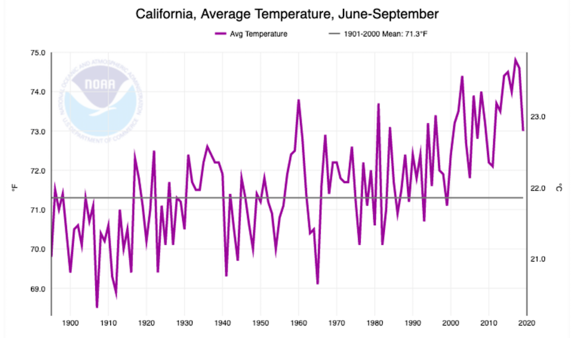
| Figure 3. Temperatures in California for the period June through September have warmed by about 3°F since 1895, roughly twice the national and global trend for the same period. Image credit: NOAA/NCEI. |
The fire-favorable trend toward “hot droughts” in California—dry periods accompanied by record or near-record heat—has strong links to human-induced climate change. This year, the four-month period from June to September wasn’t exceptionally hot by recent standards (see Figure 3 above), but the longer-term warming trend is abundantly clear. Fire-favorable weather has also become more common during the winter and spring, as dry spells allow warmer temperatures to dessicate the vegetation. California may also experience more “weather whiplash”, or ever-more-dramatic swings between wet and dry extremes in a naturally variable climate, as the century unfolds.
Since 2001, there have been 5 instances w/ 3 or more consecutive days of extremely critical fire weather. The longest streak was 4 days (Dec 4-7, 2017) but there were 5 of 6 days (Nov 8-13, 2018). Extreme areas are expected thru Wed which would be 4 consecutive & 6 of 7 days. pic.twitter.com/YHoOXKfzXt
— NWS SPC (@NWSSPC) October 28, 2019


