| Above: The Morganza Spillway on May 15, 2011, a day after its flood gates were opened. Image credit: Divine Providence: The 2011 Flood in the Mississippi River and Tributaries Project, by U.S. Army Corps of Engineers historian Charles Camillo. |
After the wettest winter in U.S. history took the Mississippi River in March to its 2nd highest flood on record in Louisiana, renewed heavy rains that fell over the past week in the Central Plains and Midwest are expected to cause an even higher crest on the river in early June, forcing the Army Corps of Engineers to open the Morganza Spillway for just the 3rd time in history. The Morganza Spillway, completed in 1954, is one of three flood-control diversion structures on the Mississippi River built in the wake of its catastrophic 1927 flood.
 |
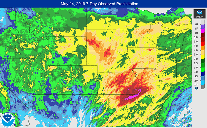
| Figure 1. Seven-day precipitation amounts ending at 8 am EDT Friday, May 24, 2019. Widespread 7-day rainfall amounts in excess of three inches, with isolated areas in excess of ten inches, fell over much of the Mississippi River watershed. Image credit: NOAA/NWS. |
Unrelenting severe weather and flooding rains have plagued the central U.S. since May 17, with widespread 7-day rainfall totals in excess of three inches recorded over much of the Mississippi River watershed. As of midday Friday, an impressive 346 of the 9054 contiguous U.S. NWS/AHPS river gauges were in flood stage. Despite the broad extent of the flooding, most of the crests fell short of all-time record levels, though Bird Creek at Avant, KS, hit 36.52' on Tuesday, beating the record of 32.03' from March 11, 1974.
The most noteworthy crest over Memorial Day weekend is likely to be on the Arkansas River at Fort Smith/Van Buren, Arkansas (metro pop. 300,000), where the river is projected to crest at 41', nineteen feet above flood stage, and well above the prior record of 38.1' from April 16, 1945. The NWS warns that at a flood level of 37’--four feet below the forecast flood level--“near catastrophic flooding occurs along the Arkansas River. The port of Fort Smith and nearby businesses are severely flooded. Several residential subdivisions around Fort Smith are flooded. Backwater flooding occurs in the trailer parks next to Lee Creek. This is an extremely dangerous and life-threatening situation.”
 |
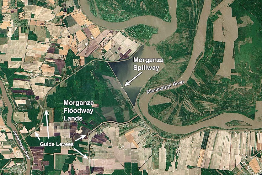
| Figure 2. Satellite view of the Morganza Spillway on May 15, 2011, one day after the spillway had been operated to relieve record flooding on the Mississippi River. Operation of the spillway allowed flood waters from the Mississippi River to flow through the structure into farmlands along the Morganza Floodway. The flood was confined by guide levees to force the water into the Atchafalaya River (left side of image). Flooding in the floodway was limited to the farmlands immediately adjacent to the spillway in this image, but later reached all the way to the Atchafalaya River. Image credit: NASA Earth Observatory via Getty Images. |
Morganza Spillway expected to open in early June
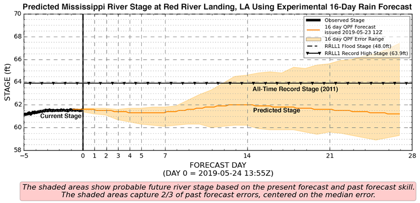
On Thursday, May 23, Louisiana Gov. John Bel Edwards said at a news conference that the Morganza Spillway was expected to open in early June, potentially as early as June 2. The Mississippi River near the spillway is expected to crest on June 5 at 62.1’, its second highest flood on record. At that height, the river will overtop the gates of the structure and cascade down the other side, potentially creating scour holes that could undermine the structure and cause its permanent failure.
The Morganza Spillway is a 3,906-foot long structure with 125 gated openings, set back about a half-mile west of the west bank of the Mississippi River near Morganza, Louisiana. When the river reaches flood stage, the Mississippi overflows its banks and its waters push up against the structure. When the gates of the structure are opened, water flows westward through farmland between two guide levees into the Atchafalaya River. Valuable farmland and several hundred structures lie in the floodway, and up to $2 billion worth of property is at risk of flooding if the spillway is opened to its full capacity (which has never happened).
 |
| Figure 3. Predicted stage of the Mississippi River at Red River Landing, Louisiana (orange line) beginning at 13:55Z (9:55 am EDT) Friday, May 24, 2019. The Red River Landing gage (RRLL1) is the closest gage to the Morganza Spillway (14 miles upstream), and river levels are predicted to rise to 62.1’, fourteen feet above the 48’ flood stage of the river, by June 5. This would be the 2nd highest flood on record, behind the 63.4’ recorded in May 2011--the last time the spillway was forced to open. The shaded orange area shows the uncertainty in the forecast based on the current 16-day Quantitative Precipitation Forecast (QPF) from the NAEFS model, which incorporates the predictions of the U.S. GFS model. The upper end of the uncertainty range, 27 days out, has the river potentially reaching 67’, which would beat the old record by over three feet. Image credit: NWS. |
History of the Morganza Spillway
As detailed in James Barnett Jr.’s fantastically detailed 2017 book Beyond Control: The Mississippi River's New Channel to the Gulf of Mexico, the Morganza Spillway was first opened during the great flood of 1973. The river did not actually reach the flow rate of 1.5 million cubic feet per second that would normally trigger the opening of the spillway, but it was forced to open in order to lessen pressure on the nearby Old River Control Structure, which was in serious danger of collapse. See our detailed May 2019 3-part post on the Old River Control Structure, If the Old River Control Structure Fails: A Catastrophe With Global Impact, to read more about the critical need to protect this structure.
The head of the Army Corps’ flood fight efforts in 1973, Major General Charles C. Noble, gave the order to immediately open the Morganza Floodway when it was discovered that a giant football-field-sized scour hole had begun to undermine the Low Sill Structure of the Old River Control Structure. The governor of Louisiana telephoned and asked if he had the authority to order that the Morganza Floodway not be opened. General Noble told him no. When complaints arose that he was not giving the promised five days' notice, he replied that the river didn't give him five days' notice.
Multiple bays of the Morganza Spillway were opened, allowing a 20-foot-high wall of water to cascade down into the farmland below. This action generated massive scour holes below the stilling basin, bringing the danger that the scour could work its way back toward the gates and undermine the structure. Fortunately, the scour holes were not severe enough to allow this.
The only other opening of the Morganza Spillway occurred in 2011, when the river hit its all-time highest flood level. Water lapped at the top of the gates and began spilling over the top due to wave action, before the structure was finally opened. Learning from the 1973 opening, the 2011 opening was done slowly, which prevented scouring holes from developing in the stilling basin. The slow release was also good from an environmental viewpoint, since it allowed wildlife, particularly the endangered Louisiana black bear, time to seek refuge before the heaviest flows inundated the floodway. The black bear had been listed as a threatened and endangered species in 1992 and the floodway was designated as its critical habitat in 2009.
The opening of the spillway flooded approximately 4,600 square miles of rural Louisiana along and near the Atchafalaya River. According to the Governor’s Office of Homeland Security and Emergency Preparedness, approximately $75.8 million in claims were filed to recover costs for flood response and recovery. This did not include damage to levees and to the oyster industry, which is hurt by fresh water flows into their salt water habitat. This also did not include damages caused by the record-size low-oxygen "dead zone" created along the coasts of Louisiana and Texas, due to the massive amount of fertilizer-laden fresh water that flowed into the Gulf of Mexico.
Have a great Memorial Day weekend, everyone!


