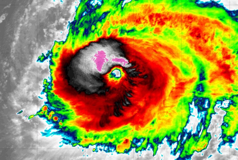
| Above: GeoColor image of Hurricane Lorenzo at 1730Z (1:30 pm EDT) Saturday, September 28, 2019. Image credit: RAMMB/CIRA/CSU. |
Hurricane Lorenzo continued to astound on Saturday with a size and intensity that are virtually unprecedented so far east in the Atlantic. As of 11 am EDT, Lorenzo’s top winds were at 115 mph, which is low-end Category 3 strength. Two NOAA reconnaissance aircraft sampled Lorenzo on Saturday as part of a research effort, and one of them reported on Saturday afternoon that the central pressure had dropped to 951 mb from the 957 mb in NHC's 11 am EDT advisory. Flight-level winds were as strong as 145 mph. Update: Lorenzo is once again a Category 4 hurricane as of 5 pm EDT Saturday, with top sustained winds of 130 mph.
Satellite imagery showed that Lorenzo had grown more symmetric on Saturday versus Friday, with very strong convection (showers and thunderstorms) sprouting around the newly dominant outer eyewall.
 |
| Figure 1. Infrared image of Hurricane Lorenzo at 1935Z (3:35 pm EDT) Saturday, September 28, 2019. Image credit: tropicaltidbits.com. |
Lorenzo peaked in strength on Friday with top winds of 145 mph, the strongest ever recorded in the Atlantic east of 45°W. The hurricane then underwent an eyewall replacement cycle that appeared to be wrapping up on Saturday. With that task behind it, Lorenzo now has an opportunity to retain its major hurricane status for at least another day or two. The official NHC forecast weakens Lorenzo very gradually, with top winds dropping into the Cat 2 range on Sunday and remaining there into Tuesday.
#Lorenzo has completed another eyewall replacement cycle, and it is possible that the hurricane is in the process of restrengthening.
— Sam Lillo (@splillo) September 28, 2019
Satellite intensity estimates have in fact taken a large leap upward in the last 3 hours, and currently have Lorenzo back to a category 4! pic.twitter.com/7jku40LZmf
An unusually supportive environment has propelled Lorenzo to its record strength for this part of the Atlantic. Wind shear is moderate to strong (15 – 20 knots), but Lorenzo is so large and powerful that it has been able to fend off any detrimental impacts. Sea surface temperatures are close to 1°C (1.8°F) warmer than average, putting the ocean well above the 26°C (79°F) threshold for tropical development.
SSTs ahead of Lorenzo should remain above 27°C (81°F) until at least Monday, as the storm travels over oceanic territory that is rarely supportive of hurricanes. In line with these factors, the 12Z Saturday run of the HWRF high-resolution model—one of the top intensity tools in the 1- to 3-day range—keeps Lorenzo as a major hurricane through Tuesday.
Track forecasts from the 12Z Saturday GFS and European models are in close agreement on bringing Lorenzo very close to the 30°W/40°N point on Wednesday. Such a track would thread the needle between the far-northwest Azores islands of Corvo and Flores and the rest of the archipelago. Lorenzo’s wind field is so vast—hurricane-force winds are predicted to extend 75 miles east of the center by Tuesday—that the predicted track could bring winds approaching hurricane force in the northwest and/or central Azores even if no direct landfall occurs. Ensemble model output from Friday night shows enough left-to-right uncertainty in Lorenzo’s track that all of the Azores should keep tabs on the hurricane’s progress toward the islands. Given Lorenzo’s vast size and strength, very high seas and sustained winds in the high tropical-storm range (50-70 mph), with higher gusts, could cause widespread trouble across large parts of the Azores on a variety of potential tracks.
Per NOAA's historical database, only 7 Cat. 2+ #hurricanes have tracked within 200 nautical miles of the #Azores. We'll see if #Lorenzo will maintain at least that intensity next week. pic.twitter.com/oY4vSOJy7S
— Jonathan Erdman (@wxjerdman) September 27, 2019
Tropical cyclones affect the Azores about every three years on average, according to hurricanecity.com. Hurricanes that make it this far northeast are typically no stronger than Category 1, although a 1926 hurricane made landfall on São Miguel island near Ponta Delgada while at peak Category 2 strength (105-mph winds). On January 15, 2016, Hurricane Alex—the Atlantic’s first January hurricane in more than 60 years—struck Terceira island as a high-end tropical storm. In October 2017, Ophelia passed well south of the Azores as a Category 3 hurricane, producing tropical storm-force winds in the islands, according to the NHC's final report. For more on Azores tropical cyclone climatology, see Jon Erdman’s weather.com writeup.
Even as it becomes a post-tropical cyclone, Lorenzo may still bring widespread tropical-storm-force winds to Ireland and the United Kingdom around Thursday, along with very heavy rain.
Reconnaissance crews help find missing sailors
Three survivors from a tugboat that ran into trouble in Hurricane Lorenzo on Thursday were rescued on Saturday with the help of NOAA Hurricane Hunters. Eleven others were still missing from the Bourbon Rhode tugboat, which was en route from the Canary Islands to Guyana. A NOAA hurricane research plane was assisting in the search Saturday. On Friday, a NOAA plane heading out to collect data on the record-breaking storm in the eastern Atlantic Ocean was diverted to the search. "At the request of the U.S Coast Guard, NOAA 43 … was asked to investigate the last known positions of search and rescue satellite hits for the vessel," Jonathan Shannon, a spokesman for NOAA's Office of Marine and Aviation Operations, told weather.com Friday afternoon.
All three @NOAA_AOML Hurricane Hunter aircraft airborne in conjunction with Hurricane #Lorenzo. N49 (Gonzo) and N43 (Miss Piggy) are double-teaming Lorenzo while N42 (Kermit) is on an international low level search an rescue mission in the sinking of the #BourbonRhode pic.twitter.com/Bqi1FSIUad
— James Hyde (@wxmeddler) September 28, 2019
Elsewhere in the tropics
Saturday was a sigh-of-relief day: the Atlantic’s first full day in more than a month with only one system (Lorenzo) being tracked as a tropical cyclone or being monitored by NHC for development. No tropical cyclones are expected to develop in the Atlantic through at least Thursday, according to the 2 pm EDT Saturday tropical weather outlook.
 |
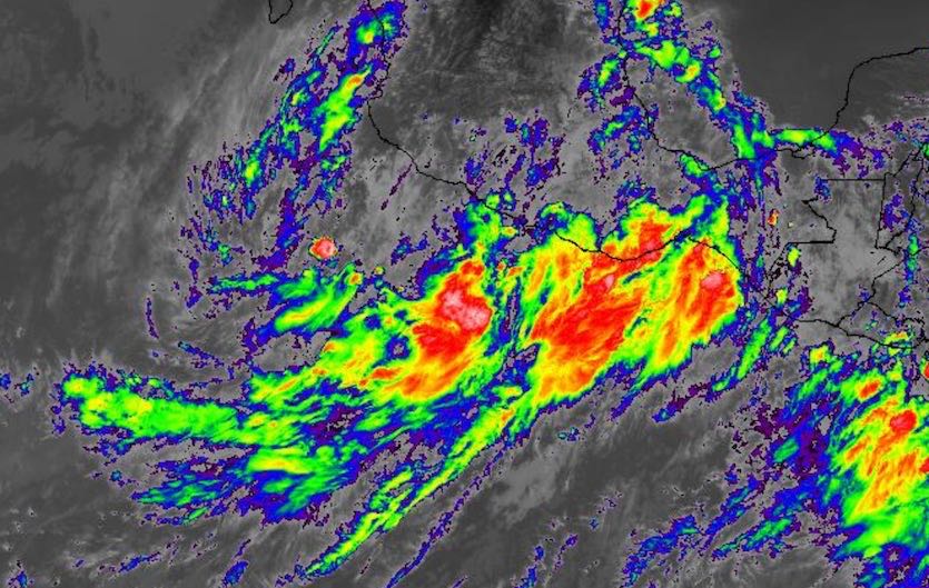
| Figure 2. Infrared image of PTC 16E at 1920Z (3:20 pm EDT) Saturday, September 28, 2019. Image credit: NASA/MSFC Earth Science Branch. |
In the Pacific, NHC launched advisories at 11 am EDT Saturday on Potential Tropical Cyclone 16E. This system is likely to become a tropical storm near the Mexico coast, following a coast-hugging path not unlike Hurricane Lorena of a few days ago. Localized rains of up to 15 inches are possible in the rugged coastal terrain, with an accompanying threat of flash floods and mudslides. PTC 16E is projected to move up the Gulf of California, on a similar track as Lorena but at much lower intensity, and another moisture plume could get slung into parts of Arizona late next week.


