| Above: Natural-color satellite image of Tropical Storm Kirk off the coast of Africa, as seen at 10:35 am EDT Saturday, September 22, 2018. Image credit: Levi Cowan, tropicaltidbits.com. |
A tropical wave dubbed 99L that emerged from the coast of Africa on Thursday night became Tropical Storm Kirk on Saturday morning, and may pose a danger to the Lesser Antilles Islands as early as Wednesday night. Kirk was located about 450 miles south of the Cabo Verde Islands at 11 am EDT Saturday, when it was upgraded by the National Hurricane Center to become the Atlantic season's 11th named storm. The Atlantic does not typically get its 11th named storm until November 23, based on 1966-2009 climatology.
Kirk was headed west at about 14 mph with top sustained winds of 40 mph. Satellite images on Saturday morning showed that Kirk was well-organized, with a well-defined surface circulation evident in ASCAT scatterometer data. The system had only a moderate amount of heavy thunderstorms, which were clumpy and did not appear well-organized. Upper-level outflow was apparent on the north side, and Kirk had one decent-looking low-level spiral band on its east side.
 |
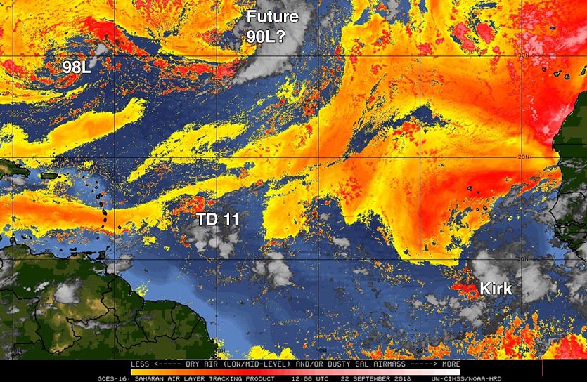
| Figure 1. Saharan Air Layer (SAL) analysis for 8 am EDT September 22, 2018. The dry air of the SAL (orange colors) lay well to the northwest of Kirk, but was strongly affecting TD 11 and 98L. A developing non-tropical low pressure system in the Central Atlantic will likley be designated 90L by Sunday. Image credit: University of Wisconsin/CIMSS. |
Kirk's future
The 12Z Saturday run of the SHIPS model predicted that SSTs along Kirk's path would remain nearly constant through Sunday, then steadily increase to a warm 29°C (84°F) by Tuesday. During this time, the atmosphere was predicted to stay moist, and wind shear light to moderate. These conditions should allow Kirk to continue strengthening gradually this weekend, and SHIPS indicates a slight chance that Kirk could undergo a period of more rapid intensification. However, Kirk's development may be limited by its rather low latitude (near 8 - 9°N), and over time Kirk will be hindered by its rapid forward speed, expected to increase to 20 - 25 mph by early next week. Only one of the operational 0Z Saturday runs of our top three models for predicting tropical cyclone development--the UKMET model--had predicted that 99L would develop into Tropical Storm Kirk. However, there was support for development from about 30% of the 50 members of the 0Z Saturday European model forecast, and over 50% of the 20 members of the 0Z Saturday GFS ensemble forecasts.
Kirk's speedy westward motion over the next several days could bring it into the Lesser Antilles Islands as early as Wednesday night, though an arrival on Thursday, as predicted by NHC, is more likely. Wind shear is predicted to increase to a high 20 – 30 knots by Wednesday and increase further on Thursday. Kirk will likely be weakening as it approaches the Lesser Antilles, and none of the ensemble members from 0Z Saturday predicted that Kirk would survive its trek through the eastern Caribbean.
TD 11 forms east of the Lesser Antilles
Despite high wind shear and dry air, Invest 98L shrugged off being given only a 10% chance of development on Friday morning, developing into a tropical depression on Friday night in the waters about 500 miles east of the Lesser Antilles. However, conditions have grown even more hostile for the depression, with wind shear a high 30 – 35 knots on Saturday morning. Satellite loops on Saturday morning showed that the depression was unraveling, with its center of circulation becoming difficult to find and its heavy thunderstorms becoming weak and disorganized. With wind shear predicted to increase to a very high 40 knots by Saturday night, TD 11’s hours are numbered, and expect the system to dissipate by Sunday without affecting any land areas.
A portion of Florence’s remains could develop next week
The Saturday morning runs of our top three models for predicting tropical cyclone genesis—the European, GFS, and UKMET models—all predicted development by Tuesday of a non-tropical surface low pressure system that closed off on Saturday in the Central Atlantic, about 900 miles west-southwest of the Azores Islands. This low is being invigorated by a portion of Florence’s remnants. SSTs are unusually warm in this region, about 25 - 26°C (77 -79°F), which is more than 1°C above average. The low will get cut off from the jet stream and meander in an area of weak steering currents for many days. In their 8 am EDT Saturday Tropical Weather Outlook, NHC gave this system 2-day and 5-day odds of development of 60% and 70%, respectively. The next name on the list of Atlantic storms is Leslie.
Weather nerds are going to love this central Atlantic low (soon to be #AL90 I guess). The phase-space diagrams are all over the map here, suggesting a fascinating transition from extratropical to (sub)tropical with time. Serious forecast challenges ahead! pic.twitter.com/ICPIVhQzsv
— Eric Blake (@EricBlake12) September 22, 2018
98L near Bermuda no immediate threat
A non-tropical low pressure system was located about 200 miles south of Bermuda on Saturday morning. This system (98L) has lost all of its heavy thunderstorms, and high wind shear and dry air should keep any development slow. The low is expected to move to the southwest of Bermuda by early next week, and then loop back to the northwest and bring rain to the Southeast U.S. as early as Tuesday. The 6Z Saturday GFS model predicted that 98L would bring less than an inch of rain to Eastern North Carolina Tuesday through Wednesday, though. None of our top three models for predicting tropical cyclone genesis—the European, GFS, and UKMET models—predicted that 98L would develop into a tropical depression. In their 8 am EDT Saturday Tropical Weather Outlook, NHC gave 98L 2-day and 5-day odds of development of 10% and 30%, respectively.
Bob Henson contributed to this post.


