| Above: Tropical Cyclone Kenneth as seen by the MODIS instrument on NASA's Aqua satellite on Tuesday afternoon, April 23, 2019. At the time, Kenneth was a minimal tropical storm with 40 mph winds. Image credit: NASA. |
Five weeks after catastrophic Tropical Cyclone Idai brought Mozambique its greatest natural disaster in history—with over 600 killed and damages in excess of $1 billion—a new tropical cyclone, Kenneth, threatens the nation.
As of the 10 am EDT Tuesday advisory from the Joint Typhoon Warning Center (JTWC), Kenneth was a tropical storm with 50 mph winds, headed west-southwest at 12 mph. The agency issuing the official forecasts for the South Indian Ocean, RSMC-La Reunion, had Kenneth as a minimal-strength tropical storm with 40 mph winds and a central pressure of 998 mb at 8 am EDT Tuesday. Kenneth was under moderate wind shear of 10 - 15 knots, over warm waters with sea surface temperatures of 30°C (86°F), and had excellent upper-level outflow—conditions very favorable for strengthening.
Le nord des #Comores et du #Mozambique sous la menace du cyclone tropical #Kenneth ces prochains jours. Impact sur le Mozambique prévu jeudi, et influence sur le nord des Comores mercredi. #Mayotte en pré-alerte cyclonique. pic.twitter.com/1GJ73wULVj
— Keraunos (@KeraunosObs) April 23, 2019
Rapid intensification expected
Both the JTWC and RSMC-La Reunion predict that Kenneth to intensify significantly over the next couple of days. The 10 am EDT Tuesday JTWC forecast called for Kenneth to peak as a Category 2 storm with 105 mph winds at 0Z Thursday, when the storm will be battering the Comoros Islands. If Kenneth enters a period of rapid intensification, which JTWC has flagged as a possibility, it could become even stronger.
 |
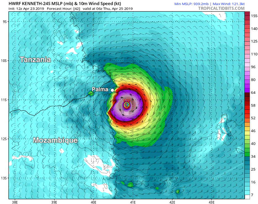
| Figure 1. Predicted surface winds (colors) at 6Z (2 am EDT) Thursday, April 25, 2019, from the 12Z Tuesday run of the HWRF model. The model predicted that Tropical Cyclone Kenneth would be approaching landfall in northern Mozambique, south of Palma (population 52,000) as a Category 4 storm with 140 mph winds. Image credit: tropicaltidbits.com. |
As Kenneth approaches landfall in Mozambique, the storm is likely to wrap dry air from continental Africa into its core, potentially causing weakening. Both the JTWC and RSMC-La Reunion predict that Kenneth will make landfall between 15Z Thursday and 6Z Friday as a Category 1 storm. A higher intensity at landfall cannot be ruled out, though. Two of our best intensity models, the HWRF and COAMPS-TC, predicted with their 6Z Tuesday runs that Kenneth would peak as a Category 4 storm with 130 – 150 mph winds, and make landfall at Category 3 or 4 strength with winds of 120 – 135 mph.
 |
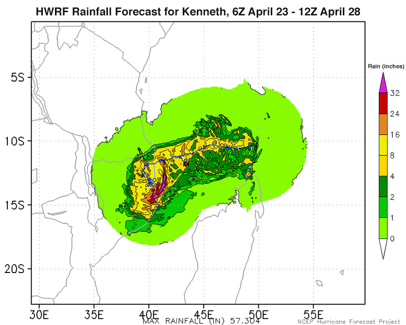
| Figure 2. Predicted precipitation for the period 6Z April 23 - 12Z April 28, 2019, from the 6Z Tuesday run of the HWRF model. The model predicted that Tropical Cyclone Kenneth would bring widespread rainfall amounts in excess of 8" (yellow colors) to coastal northern Mozambique, with a small area of rains in excess of 24" (red colors) near where the center makes landfall. Additional rainfall is possible beyond April 28 wherever a weakening Kenneth might happen to linger. Image credit: NOAA. |
Heavy rains the main threat
Kenneth will be a very wet and slow-moving storm at landfall, moving at less than 10 mph. The storm is expected to meander just inland after landfall, keeping a portion of its circulation over water and thus allowing the storm to dump potentially catastrophic rainfall amounts over northern Mozambique. Kenneth may even re-emerge over the ocean this weekend, allowing regeneration into a tropical cyclone and bringing renewed heavy rains to coastal Mozambique. The 6Z Tuesday run of the HWRF model (Figure 2) predicted that Kenneth would bring a deluge of over 8” of rain to a wide swath of coastal northern Mozambique, with a smaller region of rains in excess of 24” near where the center comes ashore. If Kenneth makes landfall as a major Category 3 or stronger storm, wind and storm surge damage will also be a big concern.
The cyclone’s impact could delay the giant natural gas projects Exxon Mobil and Anadarko are planning to start building in Mozambique’s northernmost province of Cabo Delgado later this year. Extreme flooding from Kenneth may also cause severe hardship for an emerging Islamist insurgency with remote bases in forested coastal areas near the Mozambique-Tanzania border.
Although Tropical Cyclone Idai focused its wrath on central Mozambique, where it made landfall, Idai originated as a disturbance that moved offshore from northern Mozambique, where it dumped heavy rains and displaced thousands of people.
Kenneth may become the northernmost hurricane-strength cyclone to make landfall in southern Africa
NOAA’s historical hurricanes database lists ten tropical cyclones of hurricane strength and ten tropical storms that have hit Mozambique since 1934, with last month's Tropical Cyclone Idai being the eleventh hurricane-strength cyclone to hit. Update: Mozambique has never been hit by two storms of at least Category 2 strength in the same year, so the double impacts of Idai and Kenneth this year would be unprecedented. Many storms that hit before the advent of reliable satellite imagery in the Indian Ocean in the early 1990s were likely missed, though. The nation's strongest landfalling storm was Leon-Eline, which hit southern Mozambique as a Category 4 storm with 130 mph winds on February 22, 2000. (Another cyclone, Category 1 Hudah, struck less than two months later, on April 8, 2000, affecting many of the same areas.) The only other major tropical cyclones on record for Mozambique were Favio of 2007 (Category 3, 115 mph winds) and Jokwe of 2008 (Category 3, 115 mph winds).
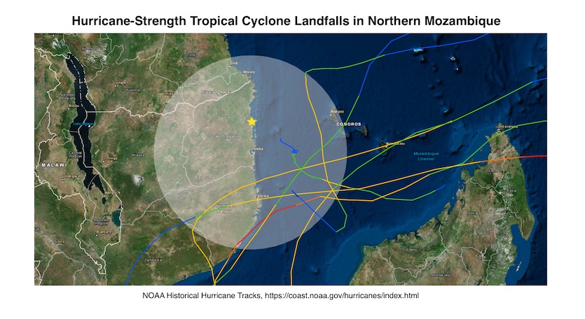
Tropical cyclone landfalls are especially uncommon toward the northern coast of Mozambique. The NOAA database shows no hurricane-strength landfalls on record in Mozambique as far north as where Idai is projected to come ashore (see Figure 2). The database shows that one tropical depression, Atang (not shown), made landfall in far southern Tanzania in 2002. A 2009 study, Climatology and Landfall of Tropical Cyclones in the South-west Indian Ocean, found only a couple of tropical cyclone landfalls north of Pemba, Mozambique. With this in mind, Kenneth is likely to be be the northernmost hurricane-strength landfall ever recorded in southern Africa.
 |
| Figure 3. Track of all hurricane-strength tropical cyclones in the NOAA historical hurricanes database to pass within 200 nautical miles (about 230 miles) of the coastal city of Pemba in northern Mozambique. The yellow star indicates where Kenneth is projected to make landfall in the 12Z Tuesday outlook from the Joint Typhoon Warning Center. Image credit: NOAA. |
Comoros Islands tropical cyclone history
The Comoros Islands, which Kenneth will begin battering on Wednesday, have very little experience with tropical cyclones, since the islands lie very close to the equator, between 11° and 13°S latitude. According to EM-DAT, the Comoros have endured only three damaging tropical cyclones since 1983. The deadliest and most destructive was Tropical Cyclone Elinah, which passed through the islands as a tropical storm with 45 – 50 mph winds on January 11, 1983, killing 33 people and doing $23 million in damage. All of the deaths occurred when a huge wave swept 40 people on the island of Anjouan into the water, killing 33 of them. The last time a hurricane-strength tropical cyclone affected the islands was on February 17, 1996, when Category 1 Doloresse passed about 40 miles to the west of the northern Comoros Islands.
Northern Indian Ocean waking up?
The northern Indian Ocean, which has two tropical cyclone seasons—in May, before the onset of the annual monsoon, and in November, after the monsoon has waned—may see its first tropical cyclone of 2019 by early next week. Both the GFS and European models have been predicting in recent runs that a tropical cyclone could form this weekend in the waters a few hundred miles east of Sri Lanka, then potentially threaten Sri Lanka and southeastern India early next week.
Bob Henson contributed to this post.


