| Above: Enhanced infrared image of Hurricane Oscar as of 1505Z (11:05 am EDT) Monday, October 29, 2018. Image credit: tropicaltidbits.com. |
Hurricane Oscar has intensified to a Category 1 hurricane with 85-mph winds as it spins over the central Atlantic, far from any land areas, and the storm has a chance to reach Category 3 strength before it speeds northwards into colder waters on Tuesday night. Oscar is not a threat to any land areas.
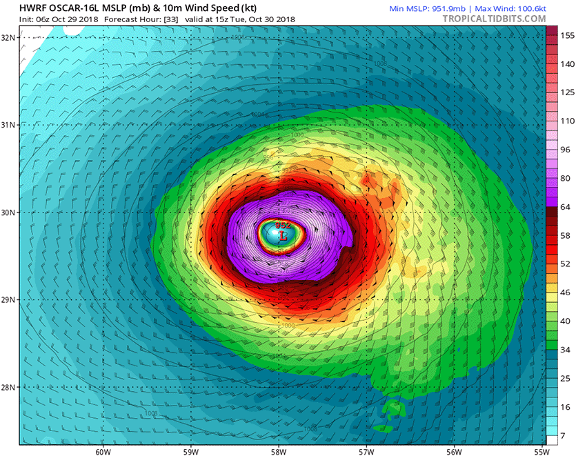
Satellite images on Monday showed that Oscar was a small but well-formed hurricane, with a prominent eye and a solid ring of heavy thunderstorms forming a respectable eyewall. Oscar was a small storm, with hurricane-force winds that extended out up to 15 miles from the center and tropical storm-force winds that extended out up to 70 miles. Small storms like Oscar can undergo rapid changes in intensity, both upwards and downwards, and the 6Z Monday runs of the high-resolution HWRF and HMON models predicted that Oscar would briefly become a major Category 3 hurricane with 115-mph winds by Tuesday morning. The official National Hurricane Center (NHC) forecast from 11 am EDT Monday was more conservative, predicting that Oscar would top out as a Category 2 hurricane with 105-mph winds on Tuesday morning.
Oscar had marginal SSTs to work with on Saturday, near 26.5°C (80°F), and moderate wind shear around 15 - 20 knots. However, the upper atmosphere was several degrees Centigrade colder than usual, thanks to cold air supplied by an upper-level low. This cold air aloft was enhancing the instability of the atmosphere and contributing to Oscar’s intensification.
Oscar was headed west-northwest at 7 mph at 11 am EDT Monday, and is now caught in the steering flow of a trough of low pressure passing to the north. In response, Oscar will turn to the north and northeast and accelerate over the next two days. On Halloween, Oscar will enter the Atlantic’s tropical cyclone graveyard, and meet a gruesome death over the frigid waters of the far North Atlantic.
 |
| Figure 1. Predicted surface winds (colors) and sea level pressure (black lines) for 11 am EDT Tuesday, October 30, 2018, from the 6Z Monday run of the HWRF model. The model predicted that Oscar would intensify into a Category 3 hurricane with 115-mph winds and a 952-mb pressure. Image credit: tropicaltidbits.com. |
An active 2018 Atlantic hurricane season
Oscar’s formation brings the 2018 tally of activity in the Atlantic to 15 named storms, 8 hurricanes, 2 intense hurricanes, and an Accumulated Cyclone Energy (ACE) index of 124. The 1981 – 2010 averages for the entire season were 12.1 named storms, 6.4 hurricanes, 2.8 intense hurricanes, and an ACE of 105.6. The 15 named storms, 8 hurricanes, and ACE index of 123 this year puts 2018 in the upper 30% for all of these quantities since the satellite era began in 1970. The Atlantic has been busier than projected by most of the groups that issued seasonal hurricane outlooks.
The Joint Typhoon Warning Center is forecasting #Typhoon #Yutu to make landfall in the northern #Philippines in approximately 6 hours with winds sustained at 90 KTS (104 MPH), gusting to 110 KTS (127 MPH). (JMA Himawari imagery) pic.twitter.com/7YzwGksf0G
— NASA SPoRT (@NASA_SPoRT) October 29, 2018
Category 2 Typhoon Yutu pounding the Northern Philippines
Heavy rains and powerful winds were sweeping across the main Philippines island of Luzon on Monday afternoon, as a steadily weakening Typhoon Yutu neared landfall. The storm's eye is expected to cross the coast of northern Luzon near 5 pm EDT Monday (5 am Tuesday local time), according to the Joint Typhoon Warning Center (JTWC). Though much reduced in intensity from its former Category 5 strength, Yutu was a formidable Category 2 storm with 105-mph winds at 11 am EDT Monday, and will be a dangerous cyclone for the Philippines.
PAGASA, the Philippines meteorological agency, was warning that a storm surge of up to 3 meters (11 feet) could be expected over the coastal areas of Isabela, Cagayan, Aurora, Ilocos Sur, Ilocos Norte and La Union. They also warned that those in low-lying areas, near rivers and in mountainous locations, should be alert for flooding and landslides. Yutu is being referred to as Rosita in the Philippines.
This same region of the northern Philippines was struck by Super Typhoon Mangkhut in mid-September, which made landfall as a Category 5 storm with 165 mph winds. Mangkhut killed at least 70 people in the Philippines, mostly due to landslides.
The core of Yutu's worst winds should steer north of the Philippines capital of Manila, but the city will receive bands of heavy rain and gusty winds.
After hitting the Philippines, Yutu will push into the South China Sea and turn northward. Land interaction with the Philippines and high wind shear will cause the typhoon to weaken to a tropical storm, but Yutu will still be capable of bringing dangerous flooding rains to southeast China later in the week.
 |
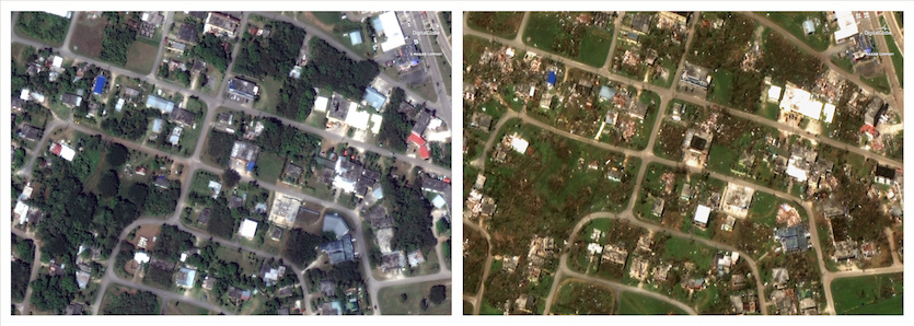
| Figure 2. This pair of satellite images provided by DigitalGlobe shows part of San Jose, a village in Tinian, on Feb. 6, 2018 (left), and on Oct. 26, 2018 (right), after Super Typhoon Yutu. Image credit: DigitalGlobe, a Maxar company, via AP. |
Marianas residents picking up the pieces after Yutu
Hundreds of people remained in shelters across the Northern Marianas Islands over the weekend in the wake of Yutu, which blasted the U.S. territory as a Category 5-strength super typhoon with 180 mph winds on Wednesday. Yutu's winds at landfall have only been exceeded by four other landfalling tropical cyclones in world history. A total of 133 people were hospitalized on Saipan, the most populous of the islands, reported weather.com. One woman was killed after she took shelter at an abandoned building. Power remained out over the weekend across Saipan and nearby Tinian, which was enveloped by the eye of Yutu as it passed overhead. The According to ReliefWeb, the American Red Cross estimated that at least 6000 homes may have been destroyed by Yutu.
On Saturday, U.S. President Donald Trump declared a major disaster in the Commonwealth of the Northern Marianas Islands (CNMI), which includes Saipan, Tinian, and Rota as well as a collection of small islands to the north. The declaration opens the way for federal assistance to residents. Food and water distribution organized by the CNMI government, FEMA, and the American Red Cross began on Sunday at five locations on Saipan. The island’s airport reopened on Sunday for commercial traffic, reported the Saipan Tribune. However, the upcoming elections have been postponed a week in the CNMI, till November 13.
Bob Henson contributed to this post.


