| Above: A postman walks through the flooded streets from Tropical Depression Imelda as he deliver mail Wednesday, Sept. 18, 2019, in Galveston, Texas. Image credit: AP Photo/David J. Phillip. |
The Atlantic and Eastern Pacific basins remain in high gear as hurricane season hits a mid-September peak. The National Hurricane Center launched advisories on four systems Tuesday, and NHC assigned four names—Lorena and Mario in the Eastern Pacific and Imelda and Jerry in the Atlantic—in the space of 18 hours. As of midday Wednesday, there were six active systems in the two basins. That ties the total from late September 1992, which is apparently a record, as tweeted by NHC’s Eric Blake and reported by weather.com’s Jon Erdman.
 |
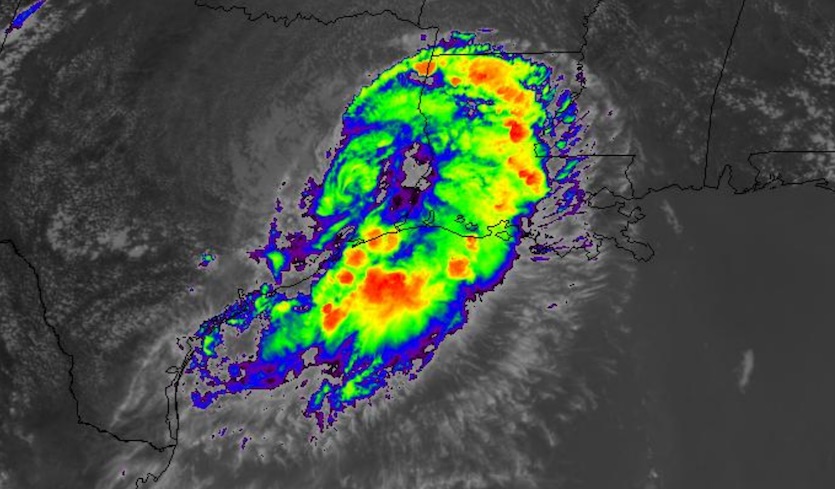
| Figure 1. Infrared satellite image of Tropical Depression Imelda over southeast Texas at 1946Z (3:46 pm EDT) Wednesday, September 18, 2019. Image credit: NASA/MSFC Earth Science Branch. |
The biggest U.S. impacts on Wednesday were from a system that’s not even being tracked by NHC anymore. Former Tropical Storm Imelda made landfall near Freeport, Texas, just 45 minutes after becoming a tropical storm. Imelda went from its first to its last NHC advisory in the space of 10 hours, which may be close to a record for a landfalling tropical storm. Now that Imelda is well inland, advisories are being issued by the NOAA/NWS Weather Prediction Center.
As of 11 am EDT Wednesday, Imelda was a tropical depression about 60 miles north of Houston, drifting slowly north. Torrential rains have been falling near Imelda’s center and along a trailing band that extends south into the Houston-Galveston area and adjacent parts of the Gulf Coast. The San Bernard National Wildlife Refuge racked up 21.37” of rain, the largest total from Imelda through 11 am EDT Wednesday. Street flooding was widespread in Galveston and parts of Houston, according to weather.com.
Per @NWSHouston, the Matagorda County, TX #Imelda rainband has been producing up to 5-inch-per-hour rainfall rates this AM. That's more rain in an hour than New York City averages in the entire month of September. pic.twitter.com/JPMd5XMbx4
— Jonathan Erdman (@wxjerdman) September 18, 2019
Imelda is behaving squarely in the classic, unfortunate tradition of slow-moving tropical cyclones that dump massive amounts of rain on southeast Texas. Tropical Storm Allison (2001) and Hurricane Harvey (2017) both led to catastrophic flooding in Houston as they spun down in eastern Texas over the course of several days. Imelda’s circulation is not as potent as those of Allison and Harvey, but the system is still bringing near-record amounts of Gulf moisture onshore.
High-resolution models indicate that the trailing band from Imelda will continue to rotate eastward from the Houston/Galveston area, possibly dumping 10-20” more rain from Wednesday into Thursday. The NOAA/NWS Weather Prediction Center has a high risk of excessive rains leading to flash floods through Thursday across far southeast Texas, extending from near Houston/Galveston to the Beaumont-Port Arthur area. Rains from Imelda should be on a slow decrease starting Thursday.
 |
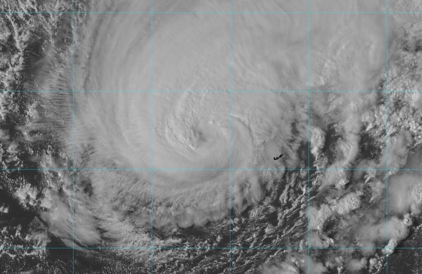
| Figure 2. Visible-wavelength satellite image of Hurricane Humberto at 1942Z (3:42 pm EDT) Wednesday, September 18, 2019. Image credit: tropicaltidbits.com. |
Category 3 Humberto to pass just northwest of Bermuda
Hurricane Humberto, the second major hurricane of the 2019 Atlantic season, will bring powerful winds to Bermuda from late Wednesday into Thursday. Packing sustained winds of 120 mph as of 2 pm EDT Wednesday, Humberto was centered about 140 miles west of Bermuda, heading east-northeast at 16 mph. On this trajectory, Humberto’s center will pass within 100 miles of Bermuda on Wednesday night. That is close enough to deliver sustained tropical-storm-force winds for a few hours, and there is about a one-in-three chance of sustained hurricane-force winds, especially at higher elevations. Bermuda is well fortified against hurricanes, but the islands that make up the territory are connected by bridges that can be affected during a tropical cyclone. Bermuda is under a hurricane warning.
At 4:49 pm EDT, a personal weather station near Somerset Village, on the western end of Bermuda, recorded a sustained wind of 76 mph with a gust to 90 mph. According to NHC, an amateur radio operator at Ports Island near the southern end of Bermuda reported a sustained wind of 75 mph and a gust to 104 mph between 4 and 5 pm EDT.
A strong midlatitude jet stream now serving to energize Humberto will help transform it into a powerful extratropical storm by this weekend as it speeds across the North Atlantic.
Strong swells from Humberto are affecting Bermuda as well as parts of the Southeast U.S. and Bahamas.
BP BREAKING| GLASS WINDOW BRIDGE CLOSSES IMMEDIATELY!!!
— Bahamas Press (@Bahamaspress) September 18, 2019
Officials on the island of Eleuthera wishes to inform motorist and other road users that the Glass Window Bridge is officially CLOSED effectively immediately due to strong sea surge. pic.twitter.com/H9JsPcVPT7
 |
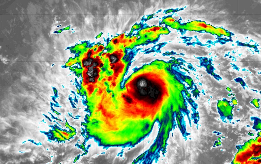
| Figure 3. Infrared satellite image of Tropical Storm Jerry at 1945Z (3:45 pm EDT) Wednesday, September 18, 2019. Image credit: tropicaltidbits.com. |
Tropical Storm Jerry hustling across western tropical Atlantic
NHC upgraded Tropical Depression 10 to Tropical Storm Jerry on Wednesday morning, and we may be dealing with this potent storm for days to come. Jerry’s top sustained winds were 50 mph at 11 am EDT Wednesday and up to 60 mph at 5 pm EDT. Jerry is already well structured, with excellent upper-level outflow and a core of intense, pulsing convection (showers and thunderstorms). NHC now predicts that Jerry will reach hurricane strength on Wednesday night.
A recent microwave overpass of #Jerry showed that the storm is continuing to get better organized, with a healthy curved-band structure. It's still not clear that the storm is perfectly aligned, but it does seem to be more aligned than earlier. pic.twitter.com/3jN9KOOVGT
— Andy Hazelton (@AndyHazelton) September 18, 2019
Wind shear will increase from low-to-medium levels (5 – 10 knots) on Wednesday to a strong 15 – 20 knots on Thursday. This may halt Jerry’s intensification, especially since dry midlevel air outside Jerry’s convective core could get driven into the storm. The environment around Jerry will moisten over the weekend, so another round of intensification may be possible at that point if the relatively strong wind shear does not interfere.
A tropical storm watch is up for St. Maarten/St. Martin, St. Barthelemy, Saba, and St. Eustatius, which may be affected by the south side of Jerry. NHC is projecting that Jerry will move near or just north of the northern Leeward Islands, then start to recurve northward by Sunday and Monday. There is strong but not complete model agreement on this outcome. The operational GFS and European track models have consistently recurved Jerry. Of the ensemble models from 0Z Wednesday, the GFS tracks were unanimous in recurving Jerry north of the Leeward Islands and into the central Atlantic, while close to 20% of the European tracks (and about 10% of the tracks from the 12Z Wednesday run) failed to recurve Jerry, allowing it to threaten the Southeast U.S. coast. Upper-level winds are structured such that a weaker Jerry would be more likely to recurve, contrary to the usual pattern of stronger systems being more likely to recurve, so any tendency of Jerry to move leftward of the NHC forecast track will need to be monitored closely.
While it currently appears that the more likely scenario is #Jerry will not directly impact the continental U.S., the Euro ensemble tracks exemplify why we cannot rule out that it comes farther west. I certainly hope for the Bahamas that it turns and avoids them. pic.twitter.com/rzZ55xlZvy
— Dr. Rick Knabb (@DrRickKnabb) September 18, 2019
Lorena to drench Mexico’s central Pacific coast
Tropical storm warnings and hurricane watches are up for parts of the Pacific coast of Mexico ahead of Tropical Storm Lorena. Packing sustained winds of 70 mph as of 2 pm EDT Wednesday, Lorena was centered about 100 miles south-southeast of Manzanillo. Lorena is predicted by NHC to become a hurricane as it draws near the coast on Wednesday night. Whether or not it makes the cut, Lorena is on track to dump torrential rains on the rugged coastal and near-coastal terrain of Mexico’s Guerrero, Michoacan, Colima, and Jalisco states. Rainfall totals of up to 15” could lead to flash floods and mudslides.
Lorena should weaken as it heads over cooler waters around Baja California this weekend. A minority of European model ensemble members bring Lorena or its remnants into the Gulf of California, which could push a surge of moisture into the Southwest U.S. later next week.
 |
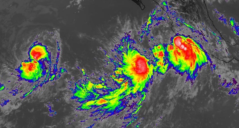
| Figure 4. Left to right: Infrared image of tropical storms Kiko, Mario, and Lorena at 1930Z (3:30 pm EDT) Wednesday, September 18, 2019. Image credit: NASA/MSFC Earth Science Branch. |
About 500 miles southwest of Lorena, Tropical Storm Mario is predicted by NHC to reach hurricane strength on Wednesday night despite northeasterly wind shear produced in part by upper-level outflow from Lorena. Mario and Lorena are close enough to each other for Fujiwhara interaction that may allow the two systems to partially rotate around each other later this week. Such an interplay would likely nudge Lorena northwestward and Mario northeastward, at least for a time. Mario is expected to remain offshore for at least the next several days.
Much further to the west, and far from any land areas, Tropical Storm Kiko is moving toward warmer waters that may allow it to regain hurricane strength by Thursday. Depending on the timing of each system, it’s possible that at some point on Thursday we’ll have three hurricanes in the Eastern Pacific and two hurricanes in the Atlantic. “Four simultaneous Atlantic hurricanes were documented both on Aug. 22, 1893, and Sept. 26-27, 1998,” noted Erdman.


