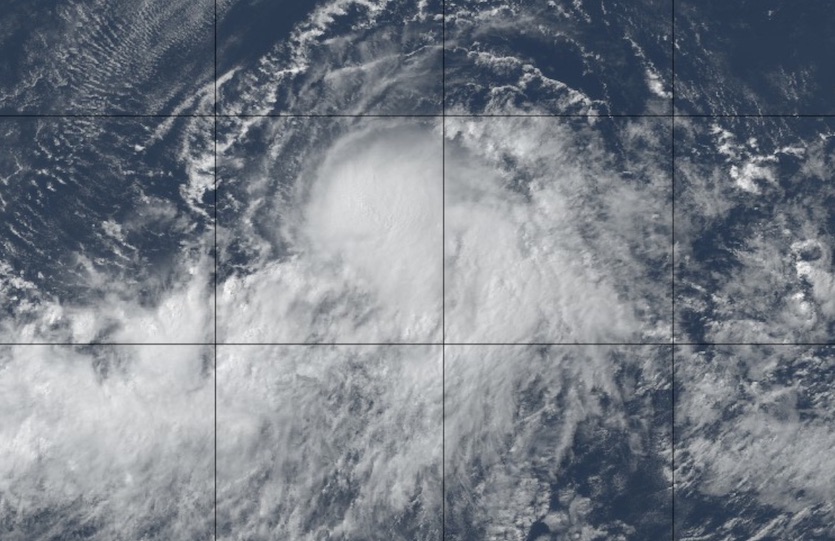
| Above: Natural-color image of Hurricane Erick at 2105Z (5:05 pm EDT) Tuesday, July 30, 2019. Image credit: tropicaltidbits.com. |
A pair of intensifying East Pacific hurricanes will push high surf toward the Hawaiian Islands over the next few days. The first of the pair, Erick, rocketed to Category 4 strength on Tuesday but is predicted to stay safely south of Hawaii. The second one, Flossie—just declared a hurricane on Tuesday afternoon—could move closer to the islands early next week, most likely as a tropical storm.
 |
| Figure 1. Infrared image of hurricanes Erick (left) and Flossie (right) as of 2300Z (7 pm EDT) Tuesday, July 30, 2019. Image credit: NASA/MSFC Earth Science Branch. |
Erick’s top sustained winds jumped from 70 mph at 5 pm EDT Monday to 130 mph by 5 pm Tuesday, a spectacular leap that’s almost double the 35-mph-in-24-hours needed to qualify as rapid intensification. Erick is the year’s second storm to reach Category 4 strength in the Pacific in 2019, following Hurricane Barbara in early July. It’s only the second hurricane this year to go beyond the minimal Category 1 strength achieved by Alvin in the East Pacific and Barry in the Atlantic.
As of 5 pm EDT, Erick was located about 840 miles east-southeast of Hilo, Hawaii, moving just north of due west at 15 mph. Erick is expected to be steered west-northwest over the next several days by steady, well-established upper flow. A slight bend back toward the west is expected later in the week, which should result in Erick’s center passing within about 150-200 miles of the Big Island’s southernmost tip on Friday.
Tropical-storm-force winds extend up to 105 miles north of Erick’s center, so if Erick sticks to the forecast track—which has strong support from multiple forecast models—Hawaii should escape tropical-storm-scale winds and rains. High surf is a virtual certainty, though: 12-foot-high seas extend out up to 230 miles northward from Erick’s center.
 |
| Figure 2. WU depiction of NHC forecast track for Erick at 5 pm EDT Tuesday, July 30, 2019. |
Erick could strengthen a bit further, as predicted by the Central Pacific Hurricane Center, which calls for a peak intensity of 145 mph on Tuesday night. Westerly wind shear will increase from Wednesday onward, pushing drier mid-level air into the storm and supporting a steady weakening from that point onward. Erick will likely be no more than a tropical storm when it comes closest to Hawaii.
Flossie a slow strengthener—and perhaps a slow weakener after that
On the heels of Erick is Flossie, which was packing top sustained winds of 75 mph at 5 pm EDT Tuesday. Flossie’s convective core is smaller than Erick’s, and it had yet to form a distinct eye on satellite imagery as of midday Tuesday, but the newborn hurricane was drawing on a vast fetch of moist air (mid-level relative humidity around 70%).
 |
| Figure 3. Natural-color image of Hurricane Flossie at 2315Z (7:05 pm EDT) Tuesday, July 30, 2019. Image credit: tropicaltidbits.com. |
Sea surface temperatures along Flossie’s path will be quite warm, about 28-29°C (82-84°F) for the next couple of days, but wind shear will be moderate to strong—around 15-25 knots. At midday Tuesday, NHC’s DTOPS rapid intensification model gave Flossie a 20% chance of hitting Category 3 strength by Wednesday. The more probable outcome is gradual strengthening that would bring the storm to Cat 2 strength, as predicted by NHC.
Flossie’s eventual unraveling in the Central Pacific could take some time. Wind shear is predicted to slacken somewhat from Thursday onward, and that would prolong the amount of time needed for infusions of drier air to weaken the storm. SSTs will remain warm enough to support Flossie (just above 26°C or 79°F, which is up to 1°C above average for this time of year) all the way to the vicinity of Hawaii. For several days, the long-range GFS and European models have kept Flossie on a track that would bring it over or near Hawaii early next week. Some members of the European ensemble run on Tuesday morning recurve Flossie just before it might reach the islands.
 |
| Figure 4. WU depiction of NHC forecast track for Flossie at 5 pm EDT Tuesday, July 30, 2019. |
The good news is that Flossie—like most hurricanes approaching Hawaii from the east-southeast—would likely weaken below hurricane strength before any close encounter with the 50th State. NHC’s latest five-day outlook has Flossie as a slowly declining Category 1 storm on Sunday afternoon, about one to two days before it might reach Hawaii. The 12Z Tuesday run of the HWRF high-resolution model, one of our top intensity models, keeps Flossie near its peak strength into Sunday. Given the slower-than-usual weakening projected by models, Flossie deserves to be watched closely.
As with Erick, Flossie could pound Hawaii with high surf for days even if it misses the islands.
Two Atlantic waves could develop toward the weekend (or beyond)
Heavy showers and thunderstorms have been peppering Puerto Rico and the Virgin Islands since Monday, the result of Invest 95L. This disturbance failed to close off a low-level center in the hostile conditions of the northeast Caribbean, but it remains a strong enough tropical wave to produce a broad shield of convection.
As it moves northwest atop the very warm waters of the Florida Straits and The Bahamas, 95L will get another chance to organize—but only a slim one, as moderate to strong wind shear and patches of relatively dry mid-level air will take their toll. Less than 10% of ensemble members from the 12Z Tuesday GFS and European model runs generate a tropical cyclone east of Florida with 95L. In its 8 pm EDT tropical weather discussion, NHC gave 95L just a 10% chance of developing into at least a depression between Thursday and Sunday. The wave could still bring showery, breezy conditions to The Bahamas and perhaps Florida’s east coast.
 |
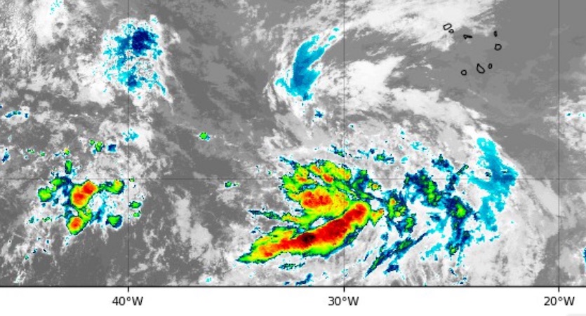
| Figure 5. Infrared image of a strong tropical wave in the eastern Atlantic (center of image) as of 2325Z (7:25 pm EDT) Tuesday, July 30, 2019. Image credit: tropicaltidbits.com. |
There’s a bit more potential for the next wave to develop. Located in the eastern tropical Atlantic on Tuesday, this disturbance will enter progressively more favorable conditions as it moves west-northwest. From the Tuesday morning model runs, about 30% of European ensemble members and a majority of GFS members show some development of this wave as it approaches the Leeward Islands in the 6- to 8-day time frame. A general northwestward track beyond that point is plausible, as suggested by the extended-range GFS and European operational runs, but the system’s fate by then would hinge on its exact track and strength, potential land interactions, and weather features that are too far ahead to pin down with any confidence.
In its 8 pm EDT tropical weather discussion, NHC gave this system a 40% chance of developing into at least a tropical depression east of the Lesser Antilles between Thursday and Sunday.


