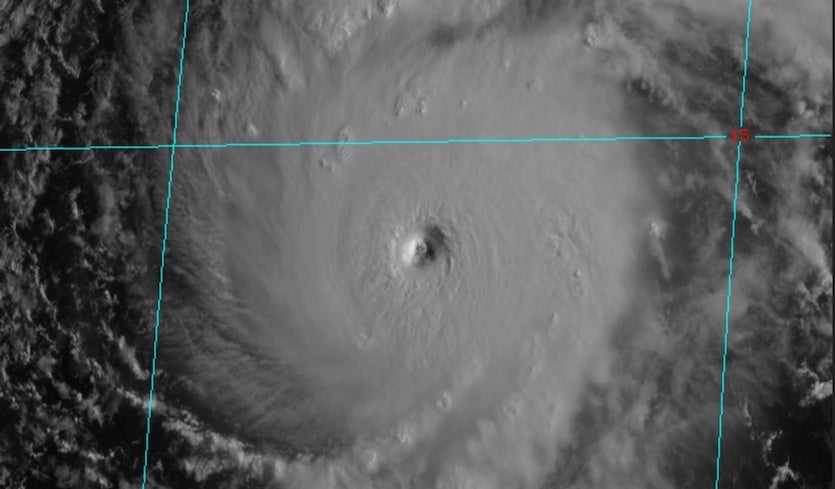
| Above: Visible satellite image of Hurricane Lane at 1800Z (8 am HST and 2 pm EDT) Tuesday, August 21, 2018. Image credit: RAMMB/CSU/CIRA. |
Hurricane watches are in place for several Hawaiian islands as Hurricane Lane—a top-end Category 4 storm on Tuesday morning, with top sustained winds of 155 mph—heads toward a potentially devastating encounter with the 50th State. A hurricane watch issued at 11 am EDT Tuesday (5 am HDT) by the NOAA/NWS Central Pacific Hurricane Center includes Hawaii and Maui Counties, which encompasses the Big Island, Maui, Lanai, Molokai, and Kahoolawe. Additional watches and warnings may be required later today and as the week unfolds.
It's uncommon for a hurricane to draw close to the Hawaiian Islands, and even more rare for one to pose a direct landfall threat, much less a hurricane this strong. Only two hurricanes on record have struck the islands directly, both of them in Kauai: Category 1 Dot in 1959, and catastrophic Category 4 Iniki in 1992.
Lane was still far from the islands on Tuesday morning—about 600 miles southeast of Honolulu, moving west at 12 mph. However, computer models have grown more insistent that Lane will turn sharply northward later this week, then carry out a broad counterclockwise loop late in the week that could involve a direct landfall on one or more of the islands. Such a track would be unprecedented in modern Hawaiian history. Even if Lane avoids a landfall, an arcing track just left of the islands could place many parts of the state on the dangerous right-hand side of the hurricane. The seriousness of the worst-case possibilities with Lane, and the rarity of the situation, call for an especially high level of preparation and vigilance among all Hawaiians.
Hurricane Hunters verify Lane's power
We’re fortunate that NOAA and the U.S. Air Force have been able to carry out dropsonde missions to keep tabs on Lane. In many other seasons, these aircraft might have been occupied with tropical cyclone threats in the Atlantic. Reconnaissance flights since Sunday have gathered invaluable observations of Lane, confirming its strength and providing data for computer forecast models to ingest. This is the first time that a NOAA P-3 has been deployed specifically to sample a hurricane threatening Hawaii. The P-3 underwent a rough flight on Monday evening, with strong turbulence reported; the plane’s Tuesday morning flight was cancelled for a maintenance check, but the Tuesday afternoon flight was still on.
Lane became a major hurricane on Friday night, August 17, and has oscillated between Category 3 and 4 strength ever since. It appears that Lane completed an eyewall replacement cycle on Monday, after which its top sustained winds ramped up to 150 mph—not far from Category 5 strength—as of 5 am EDT Tuesday.
Incredibly, reconnaissance data on Tuesday morning indicate that Lane may have strengthened even further, with an estimated central surface pressure down to 940 mb and extremely strong winds at flight levels and at the surface.
First pass through Hurricane #Lane from the USAF plane today finds pressure continuing to fall. Dropsonde into the NW eyewall at 1722Z recorded 142 knot, 163 MPH, (!) AVERAGE winds in the lowest 500m. pic.twitter.com/V2FMcMOH8y
— Alex Lamers (@AlexJLamers) August 21, 2018
Satellite imagery shows that Lane’s envelope of showers and thunderstorms (convection) has gradually expanded since Monday. The hurricane continued to look very healthy on Tuesday morning HST, with a crisp, well-defined eye surrounded by intense convection, although there has been some recurrent erosion of the strongest convection on Lane’s west side.
 Tuesday, August 21, 2018") |
| Figure 1. Infrared image of Hurricane Lane at 1800Z (8 am HST and 2 PM EDT) Tuesday, August 21, 2018. Image credit: RAMMB/CSU/CIRA. |
Lane is passing over quite warm water—around 28°C (82°F), which is 0.5°C above average for this time of year—and sea surface temperatures will remain in the 27-28°C range along Lane’s path throughout the week. Vertical wind shear is light, less than 10 knots, and that should continue through at least Thursday. The mid-level atmosphere surrounding Lane will become increasingly moist over the next couple of days, with relative humidity rising from around 55% to 60-65%. All of these factors suggest that Lane will be able to hang tough as a major Category 3 or stronger hurricane through at least Thursday. At that point, Lane will likely be about 200 miles south of the Big Island, heading north or north-northwest.
Track uncertanties loom large with Lane
The question marks become far more numerous and crucial from Thursday through Saturday. Forecast models now agree that Lane will be heading generally northward from Thursday into Friday before taking a sharp left turn on Friday and then heading generally westward. One critical question is how such an unusual track (if it verifies) would overlap with the island chain. Lacking few precedents, we must rely on computer model guidance.
The 06Z Tuesday run of the HWRF model, one of our more reliable track models, suggested that Lane could make landfall on the Big Island as a Category 2 hurricane and pass over or near Maui as a Category 1 hurricane or tropical storm, while the 12Z Tuesday run shows Lane staying just west of the Big Island before making a landfall on Maui. The GFS model shows Lane scraping the west coast of the Big Island but turning west just before reaching Maui. (We can disregard the much lower intensities shown in the GFS, since the model was not initialized with Lane’s full strength as a starting point.) Recent runs of the European model portrayed a longer but more northwestward vs. northward turn, keeping Lane well west of the Big Island and resulting in a landfall on Oahu in the 0Z Tuesday run and a track just south of Oahu and very near Kauai in the 12Z Tuesday run.
Each of these scenarios is quite concerning, but since they are so divergent, it is too soon to predict with precision whether or not Lane will pass directly over one or more Hawaiian islands. If such an encounter did occur, it would be most likely around Thursday for the Big Island and Maui and around Friday for Oahu.
The last major hurricane to directly affect the big Island or Maui likely occurred in 1871 via Businger et al (2018). Obviously different circumstances w/ #Lane, but #Lane is the biggest threat to this portion of the Hawaiian islands since this storm. https://t.co/IxO6Y4eHhe pic.twitter.com/PfaaLb10pg
— Eric Webb (@webberweather) August 21, 2018
If Lane were to pass over or very near the Big Island, damaging winds could be expected in many areas, but the higher terrain of Mauna Loa and Mauna Kea would weaken the hurricane rapidly. On the other hand, if Lane stays far enough offshore, there would remain some potential for Lane to bring hurricane-force winds to one or more islands from Maui northward. The other factor that could weaken Lane is wind shear, which is predicted to increase rapidly by Friday, as predicted by the 12Z Tuesday run of the SHIPS model. Even if Lane misses the Big Island, this wind shear will likely chip away at Lane’s strength. A caveat: it is possible that the increasing winds at the jet-stream level will also provide an outflow jet for Lane, which could help prolong its strength for a time.
Extreme rainfall, floods, and landslides possible with Lane
One of the biggest threats with Lane is the potential for massive rainfall amounts and very serious flooding and mudslides. Wherever Lane’s high winds happen to end up blowing against the steep terrain of Hawaii, rich moisture associated with the storm will be squeezed out by the upslope-flow process. CPHC is warning that 10-15” rains are possible throughout the island, with local amounts as high as 20”. Far greater peak amounts are possible on the most favored windward slopes, depending on Lane’s track (see Figure 2 below), although rain gauges may not happen to be in the right places to capture those extreme amounts.
, predicts peak rainfall totals exceeding 32” on the southeast slopes of the Big Island and 16 - 24") |
| Figure 2. This rainfall forecast for Lane, based on a single model run (the 06Z Tuesday run of the HWRF model), predicts peak rainfall totals exceeding 32” on the southeast slopes of the Big Island and 16 - 24" on Maui, peaking from Thursday, August 23, 2018, into Thursday night. Image credit: NOAA/NWS/EMC. |
Rainfall on the east slopes of the Big Island and Maui will not necessarily depend on whether or not Lane makes landfall. In fact, a track just west of the islands could allow Lane to maintain its strength and produce intense upslope and heavier rains over a longer period.
We can expect enormous local variations in rainfall amounts due to the topography of Hawaii and the complex interactions with Lane. While the highest totals may not fall on populated areas, they could still produce massive and rapid rises in rivers and creeks, with the very real possibility of landslides and road problems. For example, the road to Hana on Maui is at high risk of washouts in very heavy rain. An extreme rainfall threat could eventually extend north of Maui, depending on the ultimate track of Lane.
 at some point between Tuesday, August 21, 2018, and early Sunday, August 26, based on the current official forecast track.") |
| Figure 3. The probability of experiencing tropical-storm-force winds (sustained at 39 mph or more) at some point between Tuesday, August 21, 2018, and early Sunday, August 26, based on the current official forecast track. Image credit: NOAA/NWS/CPHC. |
Lane could produce widespread tropical-storm-force winds
Lane’s impacts will reach far beyond its immediate core. As of Tuesday morning, tropical-storm-force winds (sustained at 39 mph or more) extended up to 140 miles from Lane’s center. Rick Knabb (Weather Channel) pointed out, “It’s been a very long time - and probably not ever since the NHC/CPHC wind speed probability products were introduced more than a decade ago - that essentially every location in the state of Hawaii has a greater than 50/50 chance of winds of tropical storm force.” (See Figure 3 above). Such winds can be enough to bring down trees and power lines, especially after soils are saturated by heavy rain. The highest wind odds are along the southwest coast of the Big Island, where hurricane-force winds can be expected if Lane passes nearby or just to the west.
Widespread flight cancellations can be expected throughout Hawaii as Lane approaches, especially from Wednesday through Friday.
The bottom line: Lane poses a threat to Hawaii that is unique in the modern era of hurricane prediction and monitoring. There is increasing confidence that Lane will pass close enough to the islands to produce widespread damaging tropical-storm force winds and torrential rains. Much greater impacts are possible if and when Lane makes landfall, which is possible on the Big Island and/or Maui as soon as Thursday. It is vital that residents begin their preparations now and pay close attention to updates from the Central Pacific Hurricane Center and local authorities.
Dr. Jeff Masters contributed to this post.


