| Above: Hurricane Florence as seen from the International Space Station at 9 am EDT Monday, September 10, 2018. Image credit: Ricky Arnold. |
Florence has rapidly intensified into a dangerous Category 4 hurricane, and appears destined to strengthen even further as it heads towards the Southeast U.S. Coast. Florence is likely to make landfall on Thursday evening or Friday morning on the coast of North Carolina or South Carolina, and the odds continue to increase that Florence will stall on Friday and meander near or over the coast for several days, making the hurricane a devastating rainfall and coastal flooding threat. Update: at noon EDT, Florence was upgraded to Category 4 strength based on hurricane hunter data. Top sustained winds were near 130 mph, with the estimated central pressure down to 946 millibars, a full 15 mb lower than the estimate from 11 AM EDT.
Florence was about 580 miles south-southeast of Bermuda at 11 am EDT Monday morning, moving west at 13 mph. Sea surface temperatures (SSTs) were a warm 29°C (84°F), which is about 2°F above average. Florence was embedded in an atmosphere with dry air (a mid-level relative humidity of 50%). However, with wind shear a light 5 - 10 knots, the hurricane has successfully walled off this dry air, and is now minimally affected by it. Satellite images on Monday morning showed that the storm was significantly more organized, with a prominent eye, a more symmetrical shape, impressive spiral banding, and a strong upper-level outflow channel to the northeast. Florence was a medium-sized hurricane, with tropical storm-force winds that extended out up to 140 miles from the center. This was 25 miles farther than on Sunday morning.
There is no recent hurricane hunter data from the core of the storm, though the NOAA jet is currently engaged in a dropsonde mission to help out the 12Z cycle of models. These will come out between noon and 3 pm EDT today. A NOAA hurricane hunter aircraft will fly a research mission out of Bermuda late Monday morning, and regular hurricane hunter missions by the Air Force will begin on Monday evening. The NOAA jet will fly another dropsonde mission on Tuesday. Special balloon launches are being performed across much of the central and eastern U.S. over the next few days to double the frequency of upper air data for the models to crunch. In short, we should have steadily improving model forecasts of just where Florence will go.
 |
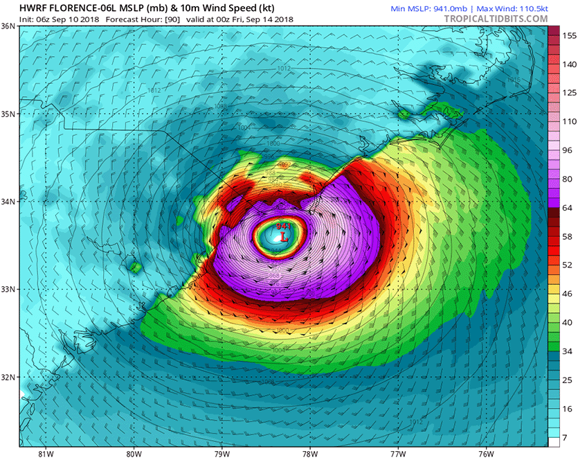
| Figure 1. HWRF model winds and pressure forecast for 8 pm EDT Thursday, September 13, from the 6Z Monday run of the model. The HWRF model was our top intensity model from 2017, and predicted that Florence would make landfall near the South Carolina/North Carolina border as a borderline Category 3 or 4 hurricane with winds of 125 mph. Image credit: Levi Cowan, tropicaltidbits.com. |
Intensity forecast for Florence: expect a Cat 4 by Tuesday
Florence’s environment is very conducive for intensification. The SHIPS model predicts shear will remain low through Wednesday night. SSTs will remain near 29°C (84°F) during this period, and ocean heat content will be high, near 35 - 50 kilojoules per square centimeter. Our top intensity models unanimously predict strengthening of Florence into a Category 4 hurricane by Wednesday, and the storm is also expected to increase in size. Florence will still be embedded in a relatively dry atmosphere, so it is possible the storm could suffer from dry air intrusions that would interfere with the intensification process, but this will likely not occur until Thursday, when wind shear is expected to increase to a moderate 10 – 15 knots.
 |
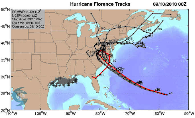
| Figure 2. The 0Z Monday, September 10, 2018 track forecasts by the operational European model for Florence (red line, adjusted by CFAN using a proprietary technique that accounts for storm movement since the time of the model run), along with the track of the average of the 50 members of the European model ensemble (heavy black line), and the track forecasts from the “high probability cluster” (grey lines)—the four European model ensemble members that have performed best with Florence thus far. The forecasts show that the uncertainty in the European model forecast has shrunk considerably, which is likely due to the inclusion of data from last night’s dropsonde mission by the NOAA jet. All of these forecasts predict a North or South Carolina landfall. Image credit: CFAN. |
Track forecast for Florence: expect a North Carolina or South Carolina landfall
The models continue to come into better agreement on the track and speed of Florence, and on Monday morning, all of the forecasts from our top five models agreed that Florence would hit North Carolina or South Carolina on Thursday evening or Friday morning. The exact location of Florence’s landfall is still fuzzy, as the average error in a 3-day and 4-day NHC forecasts are about 120 miles and 160 miles, respectively. While we do still have a few members of the GFS and European ensemble forecasts predicting that Florence will stall just off the coast and never make landfall, I put the odds of a Florence landfall on the U.S. East Coast at 90%.
 |
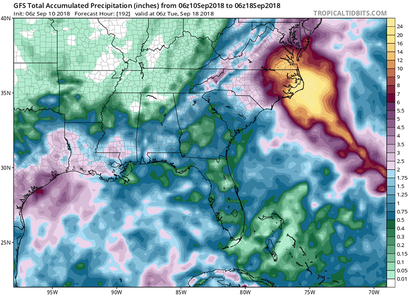
| Figure 3: If the 06Z Monday forecast from the GFS model were to verify exactly—with Florence centered in far eastern NC from Friday through Monday, September 14-17—these are the rainfall amounts that would result, as predicted by the model. Widespread 10”+ amounts would extend from Cape Hatteras to the Richmond, Virginia, area, with the Outer Banks of North Carolina receiving more than 20”. This is just one model solution: actual rainfall amounts at any point could be far less (or even greater) depending on Florence's actual track and speed. If the official NHC forecast of a landfall closer to the NC/SC border verifies, this rainfall pattern would shift farther to the southwest. Image credit: tropicaltidbits.com. |
Florence: an extreme rainfall threat
Our top five models all agree that the trough of low pressure that was expected to turn the hurricane to the north late this week will be too weak to do so, as a strong ridge of high pressure builds over the Mid-Atlantic. This “blocking ridge” is likely to block Florence’s forward progress. Florence is expected to stall and wander near or over the coast for as many as four days, potentially becoming the “Harvey of the East Coast”, dumping prodigious amounts of rain. If a significant portion of the storm’s circulation remains over water, as occurred last year with Hurricane Harvey’s stall over Southeast Texas—or even if Florence were to move into the higher terrain of western North Carolina and then stall—the rain from Florence may break all-time state records for rainfall from a hurricane or tropical storm. North Carolina’s state rainfall record from a hurricane is 24.06” from Hurricane Floyd of 1999, South Carolina’s is 18.51” from Tropical Storm Jerry of 1995, and Virginia’s is 27.00” from Hurricane Camille of 1969. There is also the danger that Florence could make landfall, then emerge back over water and re-intensify, increasing its rainfall potential.
 |
| Figure 4. Total soil moisture anomaly (departure from the 1971-2010 average, in millimeters) for the period from August 28 to September 4, 2018. Moist soils over the Mid-Atlantic will increase the likelihood of flooding from Florence. Image credit: NWS/NOAA/CPC. |
A soggy late summer has set the stage for major flood concerns. Much of the period since mid-July has been exceptionally wet over parts of the mid-Atlantic. The cities of Hatteras, NC; Washington, DC (Reagan and Dulles airports); and Wilkes-Barre and Williamsport, PA, had their wettest summers on record. For the week ending Tuesday, 4 September, soil moisture was running up to 100 millimeters (4 inches) above normal over large parts of the mid-Atlantic (see Figure 3). Preexisting saturated soils greatly exacerbate the risk of flooding, although they are not an absolute requirement. A weather.com feature notes that, for the period 1962–2012, rainfall was the culprit behind 27% of all tropical cyclones fatalities in the U.S. from 1963 to 2012.
 |
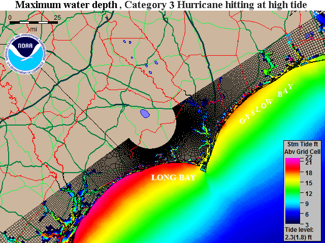
| Figure 5. Maximum of the "Maximum Envelope of Waters" (MOM) storm tide image for a composite maximum surge for a large suite of possible mid-strength Category 3 hurricanes (sustained winds of 120 mph) hitting at high tide (a tide level of 2.3) near the North Carolina/South Carolina border. What’s plotted here is the storm tide--the height above ground of the storm surge, plus an additional rise in case the storm hits at high tide. Empty brownish grid cells with no coloration show where no inundation is computed to occur. Inundation of 15 -22’ can occur in a worst-case scenario along most of the coast. Note that not all sections of the coast will experience this surge level simultaneously; the peak values would occur near and to the right of the storm's center where it makes landfall. The image was created using the National Hurricane Center’s Sea, Lake, and Overland Surge from Hurricanes (SLOSH) model. See our storm surge inundation maps for the U.S. coast for more information. |
A storm surge of 15 - 20' possible from Florence
The South Carolina and North Carolina coasts are extremely vulnerable to high storm surges, due to the large area of shallow water offshore. Two of the three historical Category 4 hurricanes that have hit this region generated a storm tide 18 - 20 feet: Hugo of 1989 and Hazel of 1954. The other storm--Gracie of 1959--did not (it hit at low tide, significantly reducing the coastal flooding). The storm tide is the combination of the storm surge and the normal lunar tide, measured in height above sea level. The National Hurricane Center uses the terminology “height above ground level” when discussing the storm tide, meaning the height the surge (plus tide) gets above the normal high tide mark. If Florence is a Category 3 or 4 hurricane at landfall, it has the capability of generating a 20-foot surge along a 10 – 40 mile stretch of the coast where the right-hand eyewall comes ashore.
If you live in a hurricane-prone location, now is a good time to make sure you have a preparedness plan in place! Tropical storm-force winds may begin along the coast as early as Thursday morning, so be sure to have all your preparations done by then. If your are asked to evacuate for the storm surge, get out!
We’ll have an update later today on the four other serious tropical cyclone threats in the Atlantic and Pacific—and the tropical disturbance headed towards Texas.
Bob Henson contributed to this post.


