| Above: Satellite-based microwave imagery (MIMIC-TC) shows the developing eye of Tropical Storm Humberto at 1945Z (3:45 pm EDT) Sunday, September 15, 2019. Image credit: CIMMS/SSEC/UW-Madison. |
Humberto became the third hurricane of the 2019 Atlantic season at 11 pm EDT Sunday, with top sustained winds of 75 mph. Humberto was centered nearly 800 miles west-southwest of Bermuda, moving northeast at 3 mph. No watches or warnings were in effect for Humberto, and the storm is likely to steer clear of land until at least midweek, when it could bring impacts to Bermuda. Swells from Humberto could affect the Southeast U.S. Coast for much of this week.
The southwesterly wind shear that’s been tilting and suppressing Humberto largely subsided this weekend, which allowed the storm to gain a more vertically stacked structure. Strong showers and thunderstorms (convection) wrapped around the west side of Humberto for the first time, and “hot towers” (pockets of intense convection) were bubbling near the center on Sunday. The storm’s outflow is much more symmetric as well. Moreover, Humberto is moving away from an ocean surface that had been slightly cooled by the passage of Hurricane Dorian a few days ago. Sea surface temperatures of 28-29°C (82-84°F) are amply warm for development.
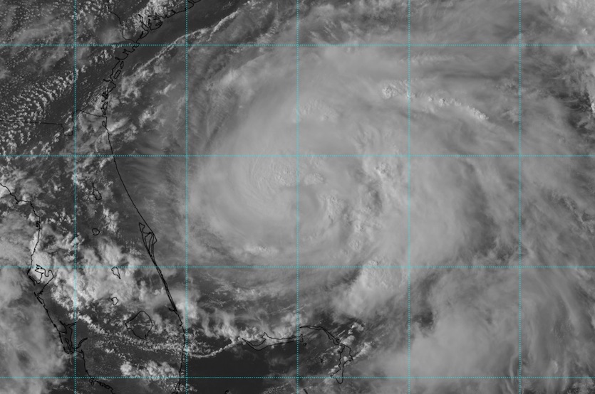 |
| Figure 1. Visible-wavelength satellite image of Tropical Storm Humberto at 2047Z (4:47 pm EDT) Sunday, September 15, 2019. Image credit: RAMMB/CIRA/CSU. |
Forecast for Humberto
Models are in close agreement on Humberto’s track the next several days. After moving slowly north into Sunday night, Humberto will take a sharp right turn on Monday and begin accelerating to the east-northeast, carted that direction by a midlatitude trough in the North Atlantic. A jet streak at the bottom of this trough will lead to strong wind shear, but in this case the orientation of the jet will actually ventilate Humberto rather than degrading its structure.
Humberto will also be passing over unusually warm waters for the subtropics. As it heads east between 30°N and 35°N latitude, Humberto will remain over 28-29°C waters, which are roughly 1.5-2.0°C (2.7-3.6°F) warmer than average. This is a significant margin when you consider that 26°C (79°F) is the oft-cited minimum for most tropical development. The subtropical SST boost Humberto may get is reminiscent of Florence in 2018, which also gained a big boost from unusually warm subtropical waters in the Atlantic.
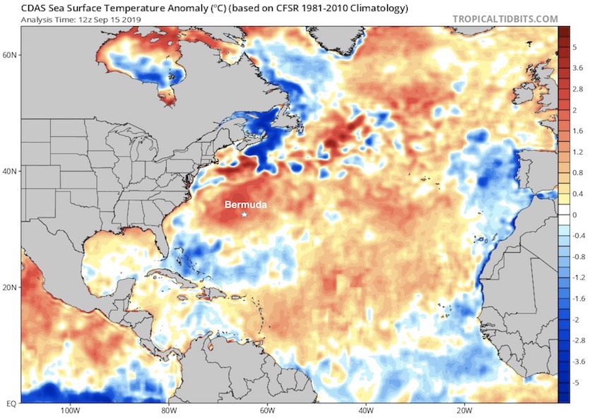 |
| Figure 2. Departures from the 1981-2010 average sea surface temperature in the North Atlantic for the date (September 15). Bermuda is near the center of a patch of SSTs up to 2°C (3.6°F) warmer than average. Image credit: tropicaltidbits.com. |
Humberto may pass close enough to Bermuda for significant impacts. The current model consensus and the NHC forecast is to take the hurricane just northwest of Bermuda around Thursday. Bermuda is well within the NHC cone of uncertainty, and any close pass to the northwest could put Bermuda in the storm’s stronger right-hand side, where winds are likely be significantly enhanced by Humberto’s rapid forward speed and perhaps upper-level winds working their way to the surface. NHC predicts that Humberto will be a top-end Category 2 storm by Wednesday as it approaches Bermuda. The HWRF and HMON high-resolution models strongly suggest that Humberto could top out as a major hurricane (Category 3 or stronger) around Wednesday or Thursday.
The long-range GFS and European model runs from 0Z and 12Z Sunday show Humberto slowing and moving northward around Friday and Saturday between Bermuda and Atlantic Canada before resuming its eastward race. A small minority (only about 10%) of GFS and Euro ensemble runs from 12Z Sunday suggested that Humberto could loop back west toward the U.S. East Coast in about a week, but this long shot can be dismissed unless and until model support increases.
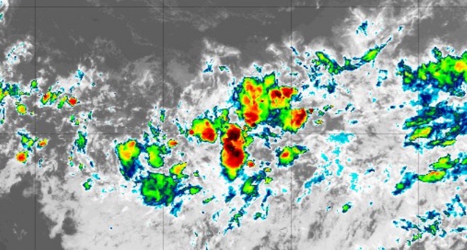 |
| Figure 3. Infrared satellite image of Invest 97L in the central tropical Atlantic at 2045Z (4:45 pm EDT) Sunday, September 15, 2019. Image credit: tropicaltidbits.com. |
Odds rising for development of 97L in the central Atlantic
A vigorous disturbance in the Main Development Region of the Atlantic tropics has a good chance of becoming a tropical depression this week. Now officially Invest 97L, this tropical wave is moving west at about 15 mph through the central tropical Atlantic and will likely angle west-northwest as the week unfolds. Convection in this wave was widespread but relatively disorganized on Sunday, with plenty of spin evident on satellite. ASCAT scatterometer imagery showed hints of a weak, open circulation center around 8°N, 40°W, near the south end of the wave. Wind shear ahead of 97L will be moderate to strong over the next couple of days (around 15 – 20 knots), the mid-level atmosphere will be moderately moist (55-60% relative humidity), and SSTs will be plenty warm, around 29°C (84°F). Wind shear will abate later this week and the atmosphere will moisten, giving 97L a better chance to develop.
In its 2 pm EDT Sunday Tropical Weather Outlook, NHC gave 97L a 30% chance of becoming at least a tropical depression by Tuesday and an 80% chance by Friday. The 0Z runs of the GFS, UKMET, and European models agreed that 97L will pass north of the Leeward Islands, although the islands need to monitor 97L until such a track is clearly unfolding. Beyond that point, the ensemble members diverge—most of them sharply recurving, but a few heading more westward. The ultimate outcome may be influenced by Humberto, which is likely to carve out a persistent weakness in the steering currents that may allow 97L to recurve.
The two Atlantic hurricanes that preceded Humberto in 2019 were a study in contrasts: barely-a-hurricane Barry, which slogged into Louisiana in July, and Category 5 monster Dorian, which delivered a catastrophic blow to the Northwest Bahamas earlier this month.
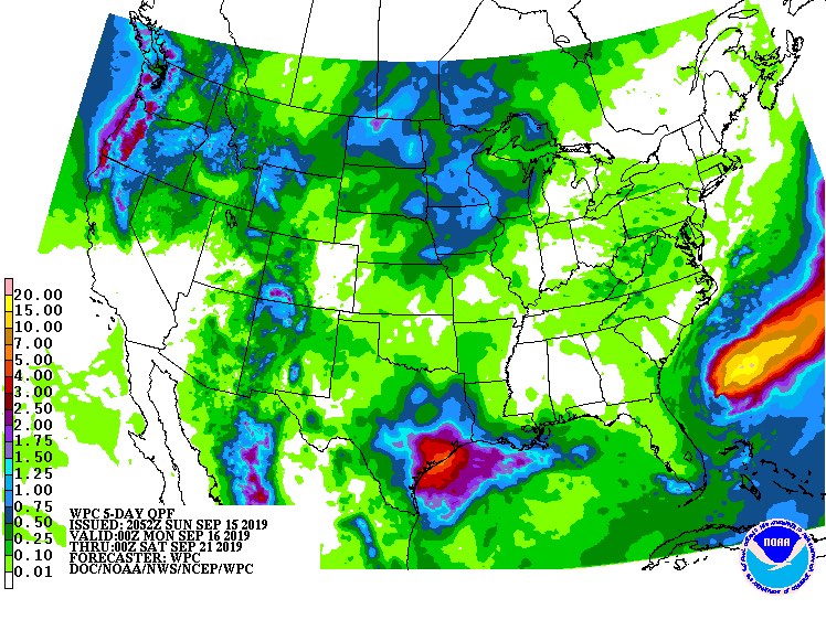 |
| Figure 4. 5-day rainfall forecast from 8 pm EDT Sunday, September 15, 2019, to 8 pm Friday, September 20. Image credit: NOAA/NWS/WPC. |
Elsewhere in the Atlantic and Northeast Pacific
Thunderstorms continue to churn across the central Gulf of Mexico on the east side of an upper low moving westward out of the Gulf. NHC gives a 10% chance of this system becoming a depression before it moves onto the Texas coast late Monday or Tuesday. Some localized flash flooding will be possible in southeast Texas, where 3" to 5" of rain could fall (see Figure 4 above), but the rains will be largely beneficial, as large parts of Texas have slid into drought in recent weeks.
The Northeast Pacific has grown quite active in recent days. Hurricane Kiko surged to Category 4 strength on Sunday more than 800 miles west-southwest of Cabo San Lucas, Mexico. Kiko will gradually weaken over the course of the week as it heads west, staying far from land. Kiko has limited banding and could eventually transition into an annular hurricane, which would make it slower to weaken.
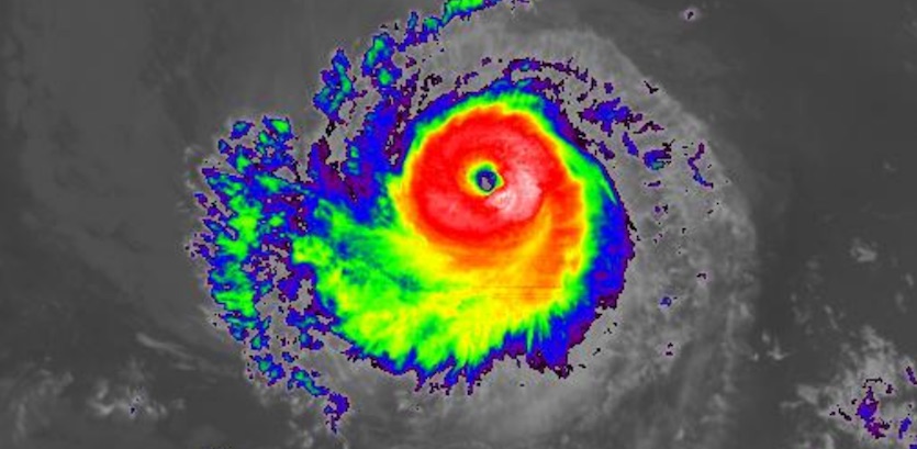 |
| Figure 5. Infrared satellite image of Hurricane Kiko at 2045Z (4:45 pm EDT) Sunday, September 15, 2019. Image credit: NASA/MSFC Earth Science Branch. |
A system of more concern in the Northeast Pacific is a strong tropical wave south of the Gulf of Tehuantepec with a large field of scattered convection. NHC gives this system 2- and 5-day odds of development of 30% and 70% as it moves northwest parallel to the coast of Mexico. Heavy coastal rains are a possibility this week depending on how this system evolves and how closely it parallels the coast. There may also be interactions with another disturbance located to the west-northwest, further offshore, that has a lower chance of development on its own.


