| Above: GeoColor visible satellite image of Hurricane Humberto at 2037Z (4:37 pm EDT) Monday, September 16, 2019. Image credit: tropicaltidbits.com. |
Hurricane Humberto flexed its muscles on Monday as it spun about 300 miles off the Southeast U.S. coast. Humberto’s top sustained winds were 90 mph, according to the 5 pm EDT advisory from the National Hurricane Center. Humberto could present a serious threat to Bermuda by Wednesday or Thursday as it accelerates in that direction. Large swells can be expected along the coast of Bermuda and the Southeast U.S. over the next several days.
Humberto carved out a distinct eye on visible satellite imagery Monday, as the hurricane took on a much more classical structure, with spiral rainbands and prominent upper-level outflow. Humberto’s shield of showers and thunderstorms (convection) expanded, with “hot towers” (pockets of intense convection) sprouting within the eyewall. Just after 3 PM EDT Monday afternoon, Hurricane Hunters found flight-level winds of 78 knots (90 mph). Humberto’s surface pressure continues to drop steadily, down to 972 mb as of 5 pm EDT. The hurricane has been strengthening at a moderate pace: about 20 knots of wind speed per 24 hours, compared to the 30 knots in 24 hours that would qualify as rapid intensification.
Well developed 'eye' formed on infrared satellite with #HurricaneHumberto - still might cause problems for Bermuda, but moving away from USA: pic.twitter.com/z1DmnELosz
— Simon Brewer (@SimonStormRider) September 16, 2019
Outlook for Humberto
Humberto will be slow to accelerate through Tuesday, but it should begin moving east-northeast at an increasing clip. As it does so, it will be traveling over exceptionally warm waters for the latitude (just north of 30°N). Sea surface temperatures in this area in mid-September are typically around 27°C (81°F)—just above the benchmark 26°C threshold for tropical development—but right now they are running closer to 28-29°C (82-84°F).
Also supporting Humberto will be a mid-level jet streak passing near and just north of the hurricane. Rather than providing destructive wind shear, the jet streak will be positioned to help ventilate and strengthen Humberto, at least for the first two or three days.
The 12Z Monday run of the high-resolution HWRF model, one of our best tools for intensity guidance in the 2- to 3-day time range, shows Humberto peaking as a Category 3 storm on Wednesday/Thursday as it passes northwest of Bermuda. NHC’s official forecast brings Humberto to Cat 3 strength even sooner—by Tuesday evening—which seems plausible given the storm’s steady rate of growth. The experimental DTOPS intensification guidance from the 18Z Monday SHIPS model run shows a 25% chance that Humberto will be a mid-range Category 3 storm (125 mph) by Tuesday afternoon.
 |
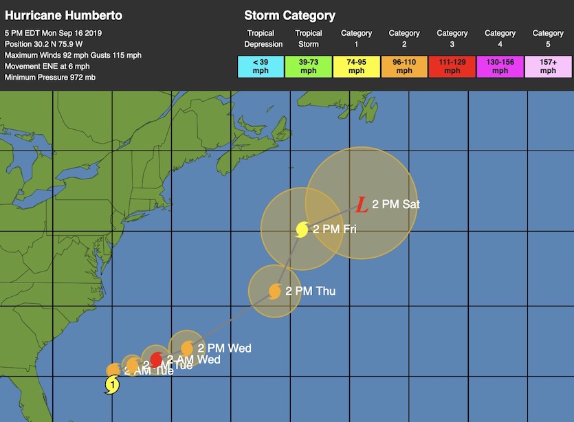
| Figure 1. WU depiction of NHC track forecast for Hurricane Humberto from 5 pm EDT Monday, September 16, 2019. |
The NHC forecast track from Monday evening brings Humberto within about 150 miles northwest of Bermuda on Wednesday night. That’s close enough to keep Bermuda just within NHC’s cone of uncertainty. Moreover, Humberto will likely have a broad field of potentially damaging winds on its right-hand side. Hurricanes often affect Bermuda, but landfalls (the center of the eye passing over land) are more infrequent. In 2014, Bermuda got a pair of hurricane hits from Category 1 Fay and Category 2 Gonzalo, which struck within a week of each other in mid-October, making 2014 the territory’s first year on record with two landfalling storms. Bermuda’s most destructive hurricane in the satellite era was Fabian in 2003, whose eastern eyewall brought Category 3 winds to the islands.
Later this week, there remains some uncertainty over whether the upper-level storm steering Humberto will continue hauling it eastward or leave it behind temporarily. A small but persistent minority of European and GFS model ensemble members show Humberto attempting to curve back toward the east coast of North America late this week, until the next midlatitude storm comes by to push Humberto eastward again. There is only a remote (and decreasing) chance that such a sharp left turn would bring Humberto significantly closer to the East Coast. A much more likely prospect is that Humberto’s east-northeast trek may pause or angle northward for a day or two, a scenario hinted at in the latest NHC track forecast for Thursday and Friday.
 |
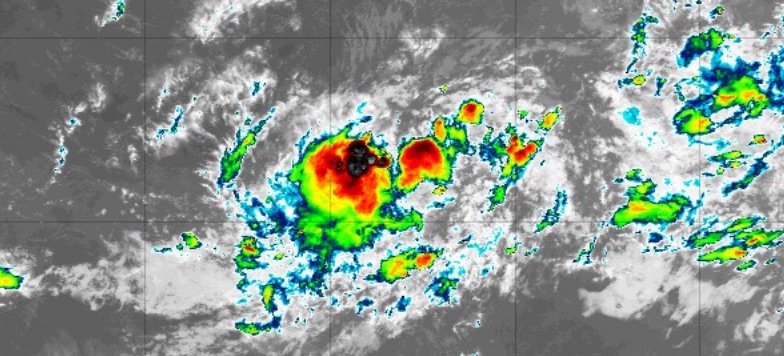
| Figure 2. Infrared satellite image of 97L at 2005Z (4:05 pm EDT) Monday, September 16, 2019. Image credit: tropicaltidbits.com. |
97L likely to develop this week; Leeward Islands need to monitor
The disturbance known as Invest 97L continues to organize in the central tropical Atlantic. An ASCAT scatterometer pass on Monday showed a broad circulation with this tropical wave, including squalls with 30-40 mph gusts on its west side. Convection has begun to consolidate and intensify around the center of the wave. For the next several days, 97L will be passing over very warm water (28-29°C or 82-84°F), and wind shear is predicted to dip into the light to moderate range (5 to 10 knots) on Tuesday and Wednesday. Mid-level moisture is also sufficient for development, with relative humidity around 60%. In its 2 pm EDT Monday Tropical Weather Outlook, NHC gave 97L a 70% chance of developing into at least a tropical depression by Wednesday and a 90% chance by Saturday.
Model ensembles agree that 97L will angle west-northwest through the week, perhaps nearing the northern Leeward Islands by Friday or Saturday. Two of our leading track models—the GFS and European—bring 97L just north of the islands in their 12Z Monday runs; the UKMET takes 97L into the northernmost Leewards. Over the longer term, it remains to be seen whether Humberto will leave enough of a weakness in the western Atlantic steering flow to allow 97L to recurve (as in the 12Z GFS run) or not (as in the 12Z Euro run). Of the model ensembles from 12Z Monday, all of the GFS members and about 80-90% of the Euro members show 97L recurving well before it might threaten the U.S. East Coast or Bahamas.
Rainfall amounts continue to be increased over the area for mid week. Significant run-off and rises on area creeks, bayous, and rivers will be possible. Just because it is not a named tropical system...don’t let your guard down #Houwx #hounews #txwx pic.twitter.com/N2WUayMLaM
— Jeff Lindner (@JeffLindner1) September 16, 2019
Southeast Texas coast may get flooding rains this week
A lackadaisical disturbance just off the Texas coast will be slow to move inland this week, resulting in a multi-day threat of heavy rains across southeast Texas. NHC gives the system a 20% chance of becoming a tropical depression before it comes ashore late Tuesday or Wednesday, later than originally expected. Data from the European model ensemble suggests that rainfall could add up to the 10-20” range somewhere close to the Houston area, obviously a worrisome prospect for this flood-weary area. GFS ensemble amounts are closer to the 5-10” range. In any case, rainfall rates of 2-4” per hour are a safe bet, and flash flooding will be a distinct possibility. It’s too soon to nail down which periods will see the heaviest rainfall and exactly where.
The National Weather Service office in Houston/Galveston offered this advice in its Monday afternoon forecast discussion: “There will be changing, potentially large run-to-run swings of model solutions. Don`t focus on just one. Just know the overall conditions are favorable for heavy rain which could cause flooding.”


