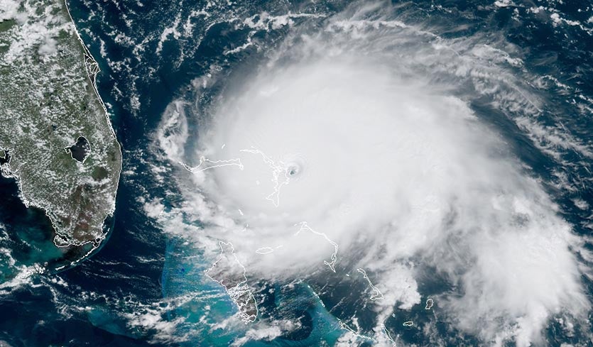
| Above: Visible satellite image of Dorian at 12:30 pm EDT September 1, 2019. At the time, Dorian was making landfall on Elbow Cay in The Bahamas with 185 mph winds, tying Dorian with the Great 1935 Labor Day Hurricane in the Florida Keys as the strongest landfalling Atlantic hurricane on record. Image credit: NOAA/RAMMB. |
Catastrophic Category 5 Hurricane Dorian made landfall in Elbow Cay in The Bahamas at 12:40 pm EDT Sunday with 185 mph winds, gusting to 220 mph, making it the strongest landfalling Atlantic hurricane on record. In the 8-hour period ending at 12:45 pm EDT Sunday, Dorian put on a rare show of rapid intensification—its already-formidable 150 mph winds increased to 185 mph, and the central pressure dropped from 934 to 911 mb.
Dorian’s forward speed of 8 mph this morning is expected to slow to just 4 mph tonight, causing an unprecedented long-duration battering of The Bahamas by one of the most extreme hurricanes in history. On Great Abaco and Little Abaco islands, hurricane-force winds will likely blow for 12 - 15 consecutive hours, interrupted only by the passage of the calm eye. For several hours, Category 5 winds in excess of 160 mph are likely, which will be capable of destroying all but the most rigorously designed concrete steel-reinforced structures. Dorian may wobble enough to the northwest to prevent Grand Bahama Island from receiving such a long pounding, but that island is still likely to experience extreme damage.
 |
| Figure 1. Composite radar image of Dorian at 10 am EDT September 1, 2019. Image credit: bahamasweather.org.bs. |
Dorian is now tied for having the second-highest winds of any Atlantic hurricanes on record:
1. 190 mph (Allen 1980)
2. 185 mph (Dorian 2019, Labor Day 1935, Gilbert 1988, Wilma 2005)
3. 180 mph (Mitch 1998, Rita 2005, Irma 2017)
4. 175 mph (11 storms, including Maria 2017, Katrina 2005, Andrew 1992, Camille 1969)
Dorian is tied for strongest landfalling Atlantic hurricane on record:
1. 185 mph: Dorian 2019 (Bahamas), Labor Day 1935 (Florida Keys)
2. 180 mph: Irma 2017 (Barbuda, St. Martin, British Virgin Islands)
3. 175 mph: Camille 1969 (Mississippi), Janet 1955 (Mexico), Dean 2007 (Mexico), David 1979 (Dominican Republic), Anita 1977 (Mexico)
Dorian’s lowest central pressure value of 911 mb at of 12:45 pm EDT Sunday does not yet make the top ten list of strongest Atlantic hurricanes by pressure; to make that list, Dorian would have to match the 908 mb pressure of Hurricane Maria (2017).
Dorian is the fifth Cat 5 in the Atlantic since 2016, joining Michael (2018), Irma (2017), Maria (2017), and Matthew (2016). This makes 2019 the fourth year in a row the Atlantic basin has had at least one hurricane reach Cat 5 strength, beating the previous record, a three-year stretch from 2003 to 2005. Including Dorian, there have been 35 Category 5 hurricanes in the Atlantic Basin, according to the National Oceanic and Atmospheric Administration (NOAA).
Dorian is the second Cat 5 globally this year, joining Super Typhoon Wutip from February in the Northwest Pacific.
Zoomed in 30-second res visible view w/ lightning of #Dorian has it makes landfall in #GreatAbaco islands in the #Bahamas.
— Philippe Papin (@pppapin) September 1, 2019
I'm speechless. This tops what we saw with #Michael last year. pic.twitter.com/6MLF7C4pD7
Observations hard to come by
There were three personal weather stations (PWSs) in the WU network that were reporting data from Great Abaco Island this morning; all of them ceased sending data by 10 am EDT. The only one with wind data reported wind gusts of 65 mph before going silent at 9:39 am EDT. The only official weather station in the path of the eye of Dorian is at Settlement Point on the extreme western end of Grand Bahama Island—the most northwesterly point in the islands. At 4 pm EDT Sunday, Settlement Point reported sustained winds of 32 mph, gusting to 37 mph, with a pressure of 1006 mb. A webcam on Grand Bahama Island was showing images of the approaching hurricane on Sunday afternoon.
Storm Chaser Josh Morgerman of icyclone.com is in Marsh Harbor on Great Abaco Island, and reported via Twitter at 11:15 am Sunday: “978 mb & falling fast. Just outside eyewall, but winds damaging. Holed up with six others in concrete room with chairs against the door.” At 11:40 am, he reported: “Pounding. CRASHING. Boards prying off windows. We're moving children to a safe space, wrapping them in blankets. 969 mb.”
New devastating video coming in from #MarshHarbor of structure damage and storm surge flooding (Bresha Kantenga) pic.twitter.com/xPv0SBEZkv
— Cris Martinez (@WPBF_Cris) September 1, 2019
Evacuations begin in Florida
Eastern portions of Indian River, St. Lucie, Martin and Palm Beach counties in Florida are under a Tropical Storm Warning, meaning that tropical storm winds in excess of 39 mph are expected in the area within 36 hours. Due to this, mandatory evacuations have been ordered for residential structures in Zone A and Zone B in Palm Beach County, effective at 1 pm Sunday, September 1, 2019. According to the Miami Herald, this includes President Trump’s Mar-a-largo resort.
| Figure 2. WU depiction of the 11 am EDT September 1, 2019 forecast for Dorian from NHC. |
Florida on the knife edge of Dorian’s track; multi-day pounding ahead for Southeast U.S.
Hurricane Dorian will deliver a punishing, historic blow to the Northwest Bahamas. On Sunday, the core of the storm will move across Great Abaco and Little Abaco islands (population 17,000), where catastrophic damage can be expected. Dorian will then then slow to a crawl on Monday as it moves near or just north of Grand Bahama Island (population 51,000). Dorian’s forward speed may be as little as 2 - 3 mph on Monday, which will prolong the devastating hurricane impacts on Grand Bahama Island. Storm surge is predicted to reach the 18 – 23 foot range at onshore locations in the Abaco Islands and Grand Bahama Island.
A slight mitigating factor for Grand Bahama Island is that the island will be on the left-hand side of Dorian’s track. In a fast-moving landfalling storm coming ashore at 15 mph, the peak winds on the right-front side of the hurricane can be expected to be about 30 mph greater than those on the left-front side. If Dorian is moving at less than 5 mph, this difference will be less than 10 mph. Thus, the “weak” southern side of Dorian’s eyewall will not be all that weak; the hurricane’s destructive winds will be spread out over a larger area, and not focused in a relatively narrow region in the right-front quadrant.
Dorian’s winds are now likely to remain at or near Category 5 strength at least into Sunday night. Normally with a hurricane this strong, a secondary outer eyewall eventually develops and the inner eyewall collapses, a process called an eyewall replacement cycle (ERC). When this happens, the peak winds may decrease by as much as 20-25 mph, but that kinetic energy does not dissipate—instead, it is spread over a broader, if slightly weaker, wind field, leading to a larger hurricane. Update: at 4 pm EDT Sunday, radar observations showed Dorian beginning to form concentric eyewalls, and an ERC appears to be beginning. Some modest weakening can be expected on Monday, in addition, as Dorian upwells cooler waters from below, due to the slow forward speed of the storm.
Dorian’s expected slowdown on Monday into Tuesday is related to a break developing in the ridge of high pressure steering the hurricane westward. Computer models are very in close agreement that Dorian will make an abrupt turn northward on Tuesday, but the location of that turn—which is critical to U.S. impacts, especially in Florida—remains in doubt. The faster Dorian moves today and Monday, the closer it could get to the Florida coast before it feels the steering tug northward.
Of the 0Z Sunday ensemble runs from two of our top tracking models, the European and GFS models, only a handful of the 50 European model members, and none of the GFS members, brought Dorian’s center inland over Florida. Two of the four European ensemble members that have done the best so far in predicting Dorian did bring the storm within about 40 miles of the coast, though, while the other two were 100 miles or so offshore. Predicting the location of Dorian’s northward turn is an excruciatingly difficult forecast challenge, since a few miles can make a vast difference in impacts, and since Dorian remains two days away from its closest approach to Florida.
The tweet below shows two model predictions made at 12Z Sunday for Dorian, valid at 1 am Wednesday, September 4, 2019. The left is the GFS model; the right is the HWRF model. Last year, the two models had nearly identical track forecasting skill for forecasts with this lead time, trailing only the European model in accuracy:
Some of the possibilities for #Florida that our morning models are giving us range from a close call 70 miles offshore (still dangerous) to an actual landfall (potentially devastating)
— Levi Cowan (@TropicalTidbits) September 1, 2019
This is a play-by-play situation. Again, be ready just in case. Listen to your local officials pic.twitter.com/fh3APWMFnd
A major, prolonged storm surge threat
Regardless of how close it gets to the Southeast U.S. coast, Dorian will push vast amounts of water against the shore for days to come. The NHC forecast keeps Dorian on an arcing path less than 100 miles offshore, from the central Florida coast on Tuesday to just southeast of Cape Hatteras on Friday. For comparison, 2016’s Hurricane Matthew—which carried out a similar loop a bit closer to shore—took less than half that long to cover the same general territory, as explained in this comparison article. Matthew led to record storm surge at several locations in Florida and Georgia, and it would not be a surprise at all to see Dorian produce similar results at some locations by later this week.
Current NHC forecasts call for 4 -7 foot inundations above ground level from the Volusia/Brevard County Line to Jupiter Inlet FL, with 2 - 4 foot inundations possible north of Deerfield Beach to Jupiter Inlet. Storm surge forecasts will no doubt be extended further northward along the Southeast coast in the days to come.
Torrential rains along and north of Dorian’s path could lead to major inland flooding, and the runoff will also complicate surge-related flooding near the coast. Rainfall rates may be slightly less than can occur when a hurricane like Dorian is moving along a preexisting or developing frontal zone, and the extent of inland rainfall will hinge closely on how close Dorian stays to the coast. Still, Dorian’s slow motion may lead to extremely high totals in at least a few spots, especially near any immediate coast and perhaps in a broader swath of eastern North Carolina, which was especially hard hit by inland flooding from Matthew in 2016 and Florence in 2018.
 |
| Figure 4. Predicted five-day rainfall totals for the week from 8 am EDT Sunday, September 1, 2019. Heavy rains may still be occurring over eastern North Carolina beyond this time range if Dorian moves as expected. Image credit: NOAA/NWS/WPC. |
Bob Henson co-wrote this post.


