| Above: An unusual sight: the National Hurricane Center (NHC) Graphical Tropical Weather Outlook at 2 pm EDT Sunday, July 7, 2019, showing a disturbance well inland over the U.S. that has the potential to emerge over water and develop into a tropical cyclone. NHC gave the system 2-day and 5-day odds of development of 0% and 50%, respectively. Image credit: NHC. |
Residents along the northeast Gulf of Mexico coast should expect to see very heavy rains and a possible tropical storm late this week after an area of low pressure, currently located several hundred miles inland over the Southeast U.S., emerges over water. There is a large amount of uncertainty in the forecast, but heavy rains of 3+ inches are likely to occur along a several hundred-mile stretch of the coast from Southeast Louisiana to western Florida by this weekend.
 |
| Figure 1. Predicted 7-day rainfall amounts ending at 8 am EDT Sunday, July 14, 2019. A tropical disturbance is expected to bring heavy rains to the northeast Gulf of Mexico. Image credit: NOAA. |
Favorable conditions for development expected
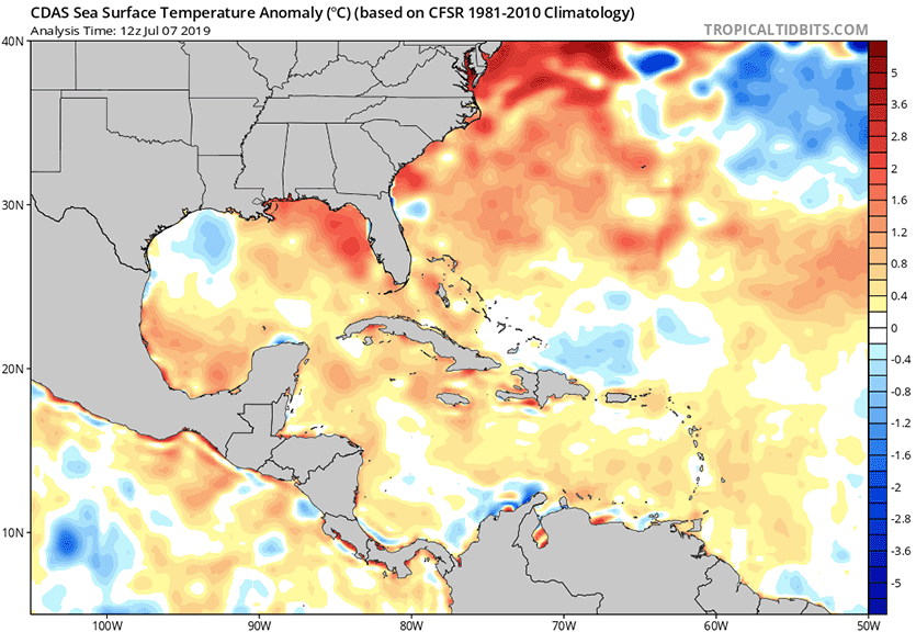
Generally favorable conditions for development are expected late this week over the northeastern Gulf of Mexico. Florida has seen one its hottest Junes on record, and this has allowed sea surface temperatures (SSTs) to become unusually warm, near 30 - 31°C (86 - 88°F). This is up to 2°C (3.6F) above average. Wind shear is predicted to be low to moderate, and the atmosphere will be moist enough to support development—though some dry air over Louisiana may wrap into the disturbance, slowing development. All three of our top models for predicting tropical cyclone formation—the European, GFS, and UKMET models—predicted with their 12Z Sunday runs that a tropical depression or tropical storm would develop in the northeastern Gulf of Mexico by Friday.
 |
| Figure 2. Departure of SST from average for July 7, 2019. The northeastern Gulf of Mexico was up to 2°C (3.6°F) above average, thanks to one of the warmest Junes on record over Florida. Image credit: tropicaltidbits.com. |
The main impediment to development would appear to be the amount of time the system is over water. The system will be disorganized when it moves over the Gulf of Mexico on Wednesday, and it will likely take the disturbance two days to take advantage of the favorable conditions for development and become a tropical storm. Friday is the most likely day the system might become Tropical Storm Barry. That is the day that the 12Z Sunday run of the GFS model has the system moving ashore over Florida’s Big Bend region, then heading northeast into Georgia.
The 12Z Sunday runs of the European and UKMET model were more concerning, since they showed the disturbance pushing farther into the Gulf, allowing the system to spend another full day over water before landfall. In the case of the European model, landfall in Louisiana on Saturday was predicted.
There is higher than usual uncertainty in the forecast at this point, since small-scale details of where thunderstorms develop during the next few days when the disturbance is over land will ultimately determine where the center emerges over water on Wednesday. At this point, we can be confident that much of Florida will get a soaking, but not much beyond that. Stay tuned.


