| Above: IR satellite image of Hector taken at 11:21 am EDT Sunday, August 5, 2018. Image credit: Levi Cowan, tropicaltidbits.com. |
Category 3 Hurricane Hector is headed west at 12 mph across the Central Pacific towards Hawaii, and could brush the Big Island with tropical storm-force winds and a few heavy rain squalls on Wednesday as the storm passes to the south. Hector peaked as a 130 mph Category 4 storm on Saturday night, but weakened slightly to Category 3 strength with 125 mph winds at 11 am EDT Sunday. Satellite imagery shows that Hector has maintained a well-formed eye surrounded by an eyewall with very cold cloud tops. Hector appears to be undergoing an eyewall replacement cycle, since Sunday morning microwave imagery showed concentric eyewalls—an inner eyewall with a diameter of about 15 miles, surrounded by an outer eyewall of greater diameter. During this process, the inner eyewall will likely collapse, leading to a weakening of the storm’s wind by perhaps 10 – 20 mph. Once the process is complete, the new outer eyewall is likely to gradually contract, and Hector may regain some of its lost intensity, if the storm has not encountered too much dry air by then. An Air Force hurricane hunter aircraft is scheduled to investigate Hector on Monday afternoon, and the NOAA jet will fy a dropsonde mission around the storm on Monday evening.
Intensity forecast for Hector
The SHIPS model predicts that Hector will be over warm waters of 27 - 27.5°C (81 - 82°F) on Sunday, then move over slightly cooler waters of 26.5 - 27° (80 - 81°F) the remainder of the week. These temperatures are on the low end of what can sustain a major hurricane, and with Hector expected to move into a steadily drier environment, slow weakening can be expected, despite low wind shear of 5 – 10 knots.
 |
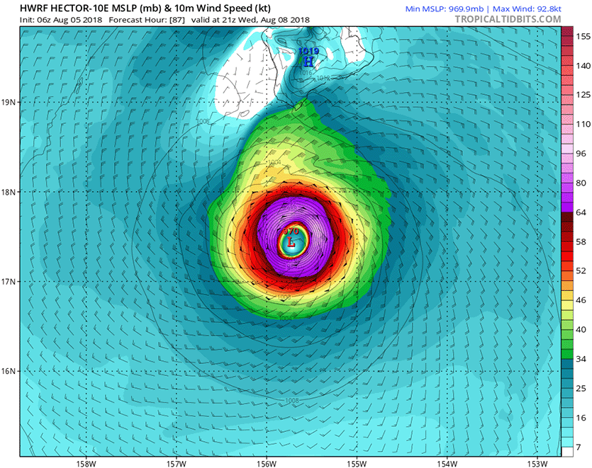
| Figure 1. Wind speed forecast for Hurricane Hector for 5 pm EDT Wednesday, August 8, 2018, made by the 6Z Sunday run of the HWRF model. Tropical storm-force winds of 34 knots (39 mph, green colors) were predicted to brush the southern tip of the Big Island. Image credit: Levi Cowan, tropicaltidbits.com. |
Track Forecast for Hector
The 0Z and 6Z Sunday runs of our top models for tracking hurricanes, the European, UKMET, GFS, and HWRF models, all showed Hector passing about 100 miles south of the Big Island on Wednesday. The 11 am EDT Sunday Wind Speed Probability forecast from NHC gave the southern tip of the Big Island approximately a 50% chance of seeing tropical storm-force winds 39 mph of greater, and Hector’s tropical storm-force winds extended up to 105 miles from the center at 11 am EDT Sunday. The 6Z Sunday run of the HWRF model predicted that Hector’s heavy rains would remain south of the Big Island, with only a few isolated spots on the island getting more than 2” of rain.
Atlantic’s 97L no threat to land
In the Central Atlantic, a non-tropical area of low pressure located about 1000 miles west-southwest of the Azores was designated as 97L by the National Hurricane Center. This low was drifting slowly to the south on Sunday morning. Satellite imagery showed that 97L had a well-defined surface circulation, but almost no heavy thunderstorms. This low will be over marginal SSTs near 26 - 27° (79 - 81°F) and under moderate wind shear of 10 – 20 knots through Tuesday, which may allow it to organize into Tropical or Subtropical Storm Debby. If 97L does become Debby, this will be a short-lived storm, as a trough of low pressure passing to the north is expected to grab the system and accelerate it to the northeast over cold waters by Wednesday. In their 8 am EDT Sunday Tropical Weather Outlook, NHC gave 97L 2-day and 5-day odds of development of 30% and 40%, respectively.


