
| Above: GOES-16 view of a Central American Gyre over the Southwest Caribbean at 11 am EDT October 4, 2018. Image credit: NOAA/RAMMB. |
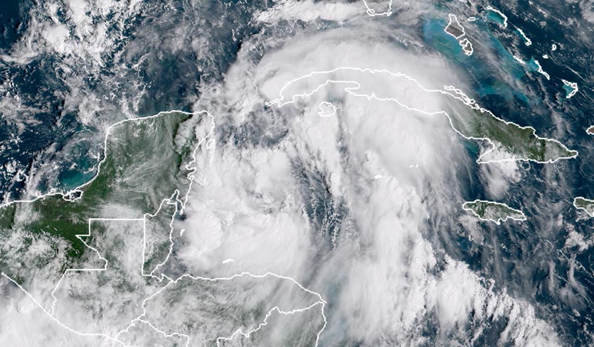
A broad area of low pressure with a large circulation was located over the southwestern Caribbean Sea on Thursday afternoon, and was generating disorganized heavy thunderstorms over much of the southwest and central Caribbean. This system has the potential to develop into a tropical depression early next week as it drifts slowly northwestward, and it will bring dangerous heavy rains to portions of Central America this week.
The broad circulation of the low makes it a good example of a Central American gyre (CAG)--a weak, sprawling cyclone that can deliver torrential rains and lead to catastrophic flooding. A gyre-analysis page from Philippe Papin (U.S. Naval Research Laboratory) shows that the circulation of this week’s CAG extends across Central America to the Pacific; Papin reported on Tuesday that the low satisfies the criteria for a Central American gyre that he and colleagues recently developed.
According to Papin, each year typically brings one or two of these gyres, most often in May-June or September-November. They tend to be more common when the active phase of the Madden-Julian Oscillation (MJO) is located in the Western Hemisphere, which is the case this week. Roughly 50 percent of Central American spawn a tropical depression or tropical storm, which tend to form on the eastern side of the gyre and rotate counterclockwise around the larger circulation.
 |
| Figure 1: GOES-16 view of the large and disorganized Tropical Storm Nate, at 10:45 am EDT Friday, October 6, 2017. Nate formed from a Central American Gyre (CAG) similar to the one we see in the Southwest Caribbean this week. Image credit: NOAA/RAMMB. |
Other CAGs that became named storms
One year ago today, a similar CAG gave birth to Tropical Depression Sixteen (TD 16) in the Southwest Caribbean off the coast of Costa Rica. TD 16 would later become Hurricane Nate, which made landfall on Louisiana’s Mississippi Delta as a Category 1 storm on October 7. Nate brought torrential rains and devastating flooding to Costa Rica, causing $562 million in damage (1% of their $57 billion GDP)--their most expensive tropical cyclone in history. Nate also did $225 million in damage in the U.S. The name Nate was retired after the 2017 season because of its impact on Central America, where 46 people died.
One other CAG from 2017 evolved into a named storm—Tropical Storm Cindy, which formed in the southern Gulf of Mexico near the northern Yucatan Peninsula. Cindy made landfall near the Texas/Louisiana border on June 22 with top winds of 50 mph, causing minimal damage. A weather.com write-up on CAGs contains a list of five other named storms that were spawned or interacted with a CAG since 2005.
0z Euro has a TS heading toward the Gulf Coast in a week. Shear is strong in the Carib. so development will be confined N of that region. *This is just a model run and not a forecast.
— Met. Eclipse (@TARCweather) October 4, 2018
What’s important is lots of models showing development and all along LA/MS coast. Stay tuned. pic.twitter.com/2Mpt3H3DpG
High shear preventing development for now
Satellite loops on Thursday showed that the low, which had not yet been given an “Invest” designation, had a surface circulation that had become fairly well-organized near the northeast coast of Honduras. The heaviest thunderstorms lay well to the east. Wind shear was a prohibitively high 20 – 40 knots, due to the presence of a strong subtropical jet stream. The large, counter-clockwise circulation of the low was pulling a flow of very moist air from the Pacific over Costa Rica, where over a foot of rain is possible by Friday, according to the 6Z Thursday run of the GFS model.
Maps showing tracks of TCs fm position east of Honduras/Nicaragua (close to where trop distbnce is now) for September (left) and October (right). Can see the climatological shift toward right in the steering currents. From screen at CSC hurricane website https://t.co/CG6N95IxxU pic.twitter.com/lY5M0nvY5z
— Dan Reilly (@DReillyWx) October 4, 2018
Maps showing tracks of TCs fm position east of Honduras/Nicaragua (close to where trop distbnce is now) for September (left) and October (right). Can see the climatological shift toward right in the steering currents. From screen at CSC hurricane website https://t.co/CG6N95IxxU pic.twitter.com/lY5M0nvY5z
— Dan Reilly (@DReillyWx) October 4, 2018Forecast for the gyre
The shear over the Western Caribbean will relent this weekend, when the subtropical jet stream is predicted to lift to the north, so that it is positioned over Cuba. This will create a region of lower wind shear over the central and western Caribbean. The 0Z Thursday run of the European model and the 12Z Thurday run of the UKMET model predicted that a tropical depression would form in the southern Gulf of Mexico, just north of the Yucatan Peninsula, by Tuesday. The 0Z, 6Z, and 12Z Thursday operational versions of our other reliable model for predicting tropical cyclone genesis, the GFS model, did not predict development. Oer 40% of the ensemble members of 0Z Thursday GFS and European models did predict development.
Any tropical cyclone that forms is likely to be slow to develop, due to the large circulation that must spin up. There may also be an upper-level low pressure system over the Gulf early next week, which would inhibit tropical cyclone development. The most likely type of storm that might evolve in the Gulf next week is a large and slow-to-intensify ugly-looking mess of a storm that would primarily be a heavy rain threat. The track such a storm might take would most likely be to the north, towards Louisiana, but we can’t rule out a threat to any region of the Gulf Coast at this point. In their 8 am EDT Thursday Tropical Weather Outlook, NHC gave the system 2-day and 5-day odds of development of 0% and 30%, respectively. The next name on the list of Atlantic storms is Michael.
 |
| Figure 2. Visible-wavelength satellite image of Hurricane Sergio at 1520Z (11:20 am EDT) Thursday, October 4, 2018. Image credit: tropicaltidbits.com. |
Category 4 Sergio lashing the Eastern Pacific
Hurricane Sergio bolted to Category 4 strength on Wednesday, piling on to what’s already been a hyperactive year in the East Pacific. Thus far, the region—defined here as extending between the International Date Line and the Americas, including the subregion known as the Central Pacific—has seen nine major hurricanes (those reaching at least Category 3 strength). In reliable records extending back to 1971, this matches the record-high number for this point in the year recorded in 1993, as noted by Phil Klotzbach (Colorado State University). Amazingly, every one of this year’s nine major hurricanes in the East Pacific has gone on to attain Category 4 or 5 strength.
The very busy 2018 hurricane season in the East Pacific has had 19 named storms, 11 hurricanes, and 9 intense hurricanes. An average season has 15 named storms, 8 hurricanes, and 3 intense hurricanes, so we are well past those benchmarks with several more weeks of hurricane season remaining. The all-time records in the East Pacific are 27 named storms (set in 1992), 16 hurricanes (set in 2015, 2014, and 1992), and 11 intense hurricanes (set in 2015).
Hurricane Hunters aren’t flying into Sergio, but visible and infrared satellite imagery leaves no doubt that it is a powerful hurricane, with intense thunderstorms (convection) wrapping around a clear eye. Peak sustained winds were estimated at 140 mph at 11 am EDT Thursday, when Sergio was located about 820 miles southwest of Cabo San Lucas, heading northwest at 9 mph. Other than hard-to-predict eyewall replacement cycles, there is no major stumbling block for Sergio maintaining its strength for the next day or two, as it cruises northwest and then angles southwest over warm waters (SSTs around 28°C or 82°F) in light to moderate wind shear (5 – 10 knots) and a moist atmosphere. Some dry air may get pulled into Sergio’s circulation by Friday or Saturday, leading to a gradual weakening. Early next week, Sergio will make a sharp turn toward the northeast, which will take it over cooler waters and into somewhat higher wind shear. The 00Z European and 06Z GFS model runs from Wednesday night suggest that Sergio could make a run for Baja California as a weakening tropical storm late next week.
The Northeast Pacific (to 180°) has already generated 56.75 #hurricane days in 2018. The only NE Pacific hurricane season with more hurricane days through October 3 is 1992 (63 hurricane days). #Sergio #Walaka pic.twitter.com/PMewQWw7JU
— Philip Klotzbach (@philklotzbach) October 3, 2018
Kong-rey weakens below typhoon status
Former Super Typhoon Kong-rey has fallen apart almost as quickly as it intensified to Category 5 strength on Monday and Tuesday. Kong-rey was packing top winds of 140 mph as of 8 pm EDT Tuesday, but fell below typhoon strength by 8 am EDT Thursday, with top sustained winds down to 70 mph as the storm passed near Japan’s Ryukyu Islands. Cooler water left in the wake of Super Typhoon Trami may have contributed to Kong-rey’s downfall. Only a few patches of strong thunderstorms remained well southeast of Kong-rey’s center on Thursday, and wind shear is about to spike dramatically, which will weaken the storm further as it sweeps across South Korea and northern Japan on Sunday.
Walaka slowly weakening
This week’s other Category 5 behemoth, Walaka, has been slower to unwind. Walaka was a high-end Category 2 storm at 11 am EDT Thursday, with top sustained winds of 110 mph. Walaka was sending high winds and surf across the far-flung Papahanaumokuakea Marine National Monument. Earlier this week, Walaka passed just 45 miles west of Johnston Island, an unpopulated U.S. territory and National Wildlife Refuge, prompting the rescue of four U.S. Fish and Wildlife Service field workers. As it continues north across cooler waters, Walaka will be absorbed this weekend by a large midlatitude storm system.
 |
| Figure 3. Infrared satellite image of Hurricane Leslie as of 1600Z (noon EDT) Thursday, October 4, 2018. Image credit: NASA/MSFC Earth Science Branch. |
The saga of Leslie continues
Hurricane Leslie continues to spin harmlessly in the central North Atlantic with little major change in its character or environment. Leslie’s top sustained winds were down to 75 mph as of 11 am EDT Thursday. Leslie’s circulation is a large one, though: hurricane-force winds extend out to 40 miles from the center, and tropical-storm-force winds out up to 195 miles. Slow weakening appears to be in the cards for Leslie, in part due to a northward backtrack that will take it over slightly cooler waters. Leslie will finally begin feeling the influence of the midlatitude jet stream by this weekend, when it will likely begin several days of east-southeastward motion as a tropical storm over waters a bit too cool for major strengthening. Later next week, a more powerful midlatitude storm may haul Leslie across or near the Azores.
Leslie is generating long-period swells of 6 – 8 feet that will affect portions of the southeastern coast of the United States, Bermuda, and the Bahamas through Friday. Persistent onshore winds will accompany these swells, generating dangerous surf and rip currents. Large swells from the hurricane are expected to increase near the coasts of New England and Atlantic Canada on Friday and Saturday.
Bob Henson co-wrote this post.


