| Above: Tropical Storm Florence and Invest 94L as seen at 1 pm EDT Friday, September 7, 2018. Image credit: NOAA/RAMMB. |
Tropical Storm Florence, beaten down by high wind shear into a tropical storm with 65 mph winds as of 11 am Friday, it likely to re-intensify early next week, and it poses an increasing danger to the U.S. East Coast by mid- to late next week.
Florence was slightly less than 1000 miles east-southeast of Bermuda late Friday morning, moving west at 8 mph. Though sea surface temperatures (SSTs) were a warm 28.5°C (83°F), Florence was struggling with dry air (a mid-level relative humidity of 45 – 50%). High wind shear of 20 – 25 knots was driving this dry air into the core of the storm, disrupting it. Satellite images on Friday afternoon showed a well-organized system, but Florence’s heavy thunderstorms were restricted to the northeast side of the center, due to the strong upper-level winds out of the southwest attacking it. A NOAA hurricane hunter aircraft will fly out of Bermuda on Saturday to investigate Florence, and the NOAA jet will fly a dropsonde mission on Saturday night.
 |
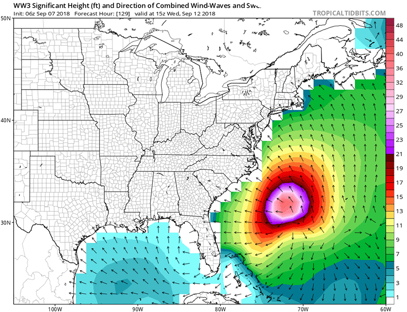
| Figure 1. Predicted wave heights for 11 am EDT Wednesday, September 12, 2018, from the 6z (2 am EDT) Friday run of the WaveWatch III model. This model, which uses the GFS model as input, predicts that large swells from Hurricane Florence will begin impacting the U.S. East Coast from North Carolina to Massachusetts beginning on Saturday. Waves as high as 40 feet are predicted for the offshore waters of the Mid-Atlantic by Wednesday, September 12. Image credit: Levi Cowan, tropicaltidbits.com. |
Intensity forecast for Florence
Florence’s environment will grow less hostile for intensification beginning on Saturday, when wind shear will drop to a moderate 10 – 15 knots. On Sunday through Wednesday, wind shear will drop to the light range, 5 – 10 knots, and SSTs will gradually increase to 29°C (84°F). Ocean heat content will double during this period, from 15 to 30 kilojoules per square centimeter. Our top intensity models unanimously predict strengthening of Florence into a Category 3 or 4 hurricane by Tuesday, and the storm is also expected to increase in size. Florence will still be embedded in a relatively dry atmosphere, so it is possible the storm could suffer from dry air intrusions that would interfere with the intensification process, though.
Big waves coming
Florence’s power and expanding size will generate swells that will begin to affect Bermuda on Friday, and the U.S. East Coast by Saturday. Swells will also propagate to north and northeastward-facing coasts of the Lesser Antilles, Puerto Rico, Hispañola, the Turks and Caicos and the Bahamas into this weekend. These swells will produce life-threatening surf and rip current conditions at beaches.
A glancing blow for Bermuda most likely
While there remains uncertainty in Florence's track, there is a farther south trend in recent forecast model output. Remember that the forecast cone produced by the NHC below shows the potential track of the center of Florence, but impacts from a hurricane extend some distance from the center. If Florence tracks along the northern edge of the NHC cone of uncertainty, it could bring tropical storm-force winds of 39+ mph to Bermuda on its nearest pass Tuesday. At that time, Florence’s tropical storm-force winds will likely extend out 120 – 140 miles to the north of the eye. However, if Florence tracks near the southern edge of the cone, Bermuda may see little more than some outer rainbands and wind gusts. There are no watches for Bermuda at this time.
 |
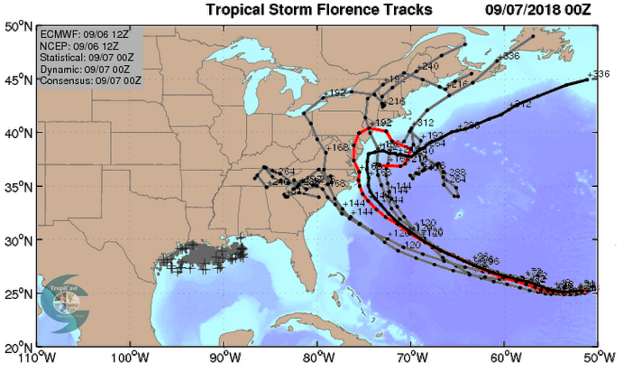
Figure 2. The 0Z Friday, September 7, 2018 track forecast by the operational European model for Florence (red line, adjusted by CFAN using a proprietary technique that accounts for storm movement since the time of the advisory), along with the track of the average of the 50 members of the European model ensemble (heavy black line), and the track forecasts from the “high probability cluster” (grey lines)—the five European model ensemble members that have performed best with Florence thus far. The forecasts show a wide range of possible landfall locations, or Florence potentially going out to sea. Image credit: CFAN. |
Invest 94L: will it impact Florence's track?
An elongated area of low pressure has developed in the waters a few hundred miles west of Bermuda, and the associated heavy thunderstorm activity began to show some organization on Friday afternoon. This system was designated 94L by NHC on Friday morning. If 94L shows some significant organization this weekend--which is possible, given the warm waters and low to moderate wind shear expected--it could end up altering the path of Florence. The models have not yet picked up on 94L very well, and we will likely have to wait until tonight's 0Z runs to see if 94L is expected to alter Florence's track. 94L will likely move little or drift slowly northeast through this weekend. In their 2 pm EDT Friday Tropical Weather Outlook, NHC gave 94L 2-day and 5-day odds of development of 10% and 20%, respectively.
Something to watch with 94L--I saw a presentation a few years ago that showed that Hurricane Katrina of 2005 increased markedly in size after it absorbed a small area of disturbed weather over the southeast Gulf of Mexico, and stole its spin. If Florence manages to absorb 94L, the increased spin the combined system will have may act to expand Florence's size considerably, leading to a larger storm surge and an increased area of wind and rainfall impacts.
Beating a dead horse, but there's been a lot of noise even of late how climatology doesn't favor Florence hitting the US. Unfortunately, when you have a record breaking ridge sitting north of #Florence in the medium range, it's not going to take a climatologically favored track. pic.twitter.com/S3J4idjBzh
— Eric Webb (@webberweather) September 7, 2018
Track forecast for Florence: a growing danger for the U.S. East Coast
The forecast of Florence and impact to the U.S. East Coast mid- to late next week remains very uncertain, but the danger to the coast is increasing.
The models are in good agreement that Florence will head west during the next two days, then turn to the west-northwest on Sunday through Tuesday. As Florence approaches the coast on Wednesday, the strength and orientation of the ridge of high pressure steering it will be key to determining Florence’s track, and there is substantial model disagreement on this. There are three main scenarios, as outlined by Jon Erdman at weather.com:
Scenario 1: If the high-pressure ridge is stronger and extends farther west, that would increase the chance of a hurricane landfall along the East Coast, particularly over the Southeast U.S. coast between Georgia and North Carolina, with the hurricane then driving inland.
- Prognosis: Increasingly possible. The latest 0Z and 12Z runs of the European, GFS, and UKMET models all support this solution.
Scenario 2: If the high-pressure ridge is weaker and doesn't extend as far west, that would diminish but not eliminate the chance of a landfall. However, that could still bring Florence uncomfortably close to the East Coast, resembling a slow moving nor'easter. Several days of damaging surf, coastal flooding and beach erosion would occur in this scenario along at least a portion of the East Coast, with the mid-Atlantic coast at risk of a direct hit.
- Prognosis: Possible
Scenario 3: Florence may remain sufficiently far enough offshore to avoid even significant coastal flood impacts.
- Prognosis: Less possible
There is a large amount of uncertainty in this long-range forecast, with all three scenarios in play. The average error in a 5-day official NHC forecast in recent years has been about 200 miles, and with Florence likely six days from landfall today, we can expect that a direct hit from Florence could happen anywhere along the swath of coast from northern Florida to Massachusetts.
All interests along the U.S. East Coast from Florida to New England should monitor closely the forecast of Florence. If you live in a hurricane-prone location, now is a good time to make sure you have a preparedness plan in place.
We’ll have an update on Olivia, a hurricane that Hawaii needs to watch, in a post later today.
Jon Erdman of weather.com and Bob Henson contributed to this post.


