| Above: Natural-color satellite image of Hurricane Florence at 1605Z (12:05 pm EDT) Thursday, September 6, 2018. Image credit: tropicaltidbits.com. |
Hurricane Florence’s first phase as a major hurricane came to an end overnight Wednesday night, but Florence is expected to reintensify into a large and dangerous storm that could pose multiple threats for Bermuda and the U.S. East Coast in the next week.
As of 11 am EDT Thursday, Florence was located in the open subtropical Atlantic, about 1100 miles east-southeast of Bermuda, moving northwest at 10 mph. Florence has weakened to a Category 2 storm, with top sustained winds of 105 mph. Earlier, on Tuesday and Wednesday, Florence intensified to Category 4 strength despite the presence of widespread strong wind shear and only marginally warm waters. It appears that Florence, a compact hurricane, had found a pocket of lighter wind shear just big enough to nurture its growth. However, the stronger shear eventually caught up with Florence, and the hurricane’s core of showers and thunderstorms (convection) was dramatically eroded from the southwest late Wednesday, eventually eating into the hurricane all the way to its eye.
Over the last day or two, southwest shear appears to have pushed Florence’s track a bit further north than expected (see embedded tweet below). The shear will be relenting markedly starting on Thursday, as Florence slows down and takes a turn toward the west indicated by all model guidance.
Notice how #Florence has been tracking to the north of all the reliable guidance (red plot vs blue plots). This is at least partially explained by the strong southwesterly wind shear. This northward bias may straighten out once the shear subsides. (plots via @btangyWx) pic.twitter.com/gUK4EvgBcM
— Michael Lowry (@MichaelRLowry) September 6, 2018
Notice how #Florence has been tracking to the north of all the reliable guidance (red plot vs blue plots). This is at least partially explained by the strong southwesterly wind shear. This northward bias may straighten out once the shear subsides. (plots via @btangyWx) pic.twitter.com/gUK4EvgBcM
— Michael Lowry (@MichaelRLowry) September 6, 2018Intensity forecast for Florence
The wind shear around Florence is currently running around 25 knots, and that will continue into Friday, as predicted by the 12Z Thursday run of the SHIPS model. Given this hostile environment and its compromised structure, Florence is expected to weaken to Category 1 strength by Friday. However, wind shear is predicted to drop below 10 knots from late Friday and remain quite light through at least Monday, a setup very conducive to restrengthening. The atmosphere around Florence is not especially moist—the relative humidity at mid-levels of the atmosphere is only around 50%—but that value should gradually increase to around 55% over the next few days. Up to now, the relatively dry environment hasn’t impeded Florence much at all, as noted by Michael Lowry (FEMA).
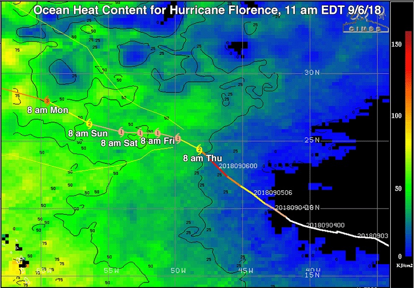
Florence will also be passing over gradually warmer waters starting Friday, encountering sea surface temperatures (SSTs) in the 28 – 30°C range (82 – 86°F) throughout the weekend. These are more than adequate to support intensification. The oceanic heat content along Florence’s track will also be increasing, which will help keep Florence from churning up cooler water and will further support any strengthening.
 |
| Figure 1. Ocean Heat Content (OHC) in kilojoules per square centimeter along the past and future predicted track (with forecast times in EDT) of Hurricane Florence as of the 11 am EDT Thursday, September 6, 2018 NHC advisory. Florence will be traversing a region of ocean with increasing SSTs and OHC during the coming five days. On Monday, Florence is forecast to cross a warm eddy with OHC values near 75 kilojoules per square centimeter, a few hundred miles southeast of Bermuda. OHC levels this high are often associated with rapid intensification of hurricanes. Image credit: University of Wisconsin/CIMSS. |
Our top intensity model from 2017, the HWRF, predicted in its 06Z Thursday run that Florence will again be a Category 3 storm as soon as Saturday night. This strengthening trend is reflected in the multi-model consensus, and NHC is forecasting Florence to regain Category 3 strength by Monday. Assuming that Florence holds its strength or reintensifies as expected, it will gradually become a larger hurricane over time, which will broaden its potential for wind and wave impacts.
Track forecast for Florence
There remains a great deal of uncertainty over the specifics of Florence’s track next week, but there are increasing signs that it could draw near enough to the U.S. East Coast to bring multiple days of pounding waves and swells, and an East Coast landfall is well within the realm of possibility. Before then, Bermuda will need to keep a very close eye on this hurricane.
At the end of the five-day NHC forecast period (Tuesday morning), Florence is predicted to be an intensifying 120-mph hurricane located about 200 miles south of Bermuda. The typical error at five days is enough to put Bermuda in the “cone of uncertainty”; on average, there is a one-in-three chance that a given hurricane will stray outside the cone. If Florence tracks just south of Bermuda, it will put the island in the dangerous right-hand side of the storm. The NHC forecast assumes that Florence will slow down and track westward through Saturday, then angle back west-northwest on a gradually accelerating track through Tuesday, as steering currents strengthen.
 |
| Figure 2. Predicted tracks for Florence from the 50 members of the 0Z Thursday run of the European ensemble forecast (left) and the 20 members of the 0Z Thursday GFS ensemble forecast (right). About 50% of the lower-resolution European model ensemble forecasts (grey lines) along with the high-resolution deterministic forecast (red line) predicted that Florence would hit the U.S. East Coast next week. About 20% of the GFS ensemble members predicted a U.S. East Coast landfall, as well. Image credit: CFAN. |
The looming question beyond Tuesday is where Florence heads next, and it’s still too soon to answer that question with confidence. Hurricanes in the general location of Florence rarely reach the United States; more typically, they recurve well before that point. However, the models agree that an upper-level ridge of high pressure will be stronger than usual across the Northeast U.S. and Northwest Atlantic next week, and this raises the odds of a potential U.S. landfall. The big question is whether any breaks in this ridge will allow Florence to recurve at some point early next week. The European and GFS model ensembles (see Figure 2 above) each include some members that steer Florence out to sea and others that bring Florence onto the East Coast. Overall, though, the European model is more inclined than the GFS model to produce a landfall.
The 0Z Thursday operational run of the European model brings Florence into North Carolina on Wednesday night, September 12, while the 0Z and 6Z Thursday runs of the GFS take Florence on a slow clockwise loop several hundred miles off the mid-Atlantic and Northeast coast. The 12Z Thursday run of the GFS brings Florence into southeast New England on Friday, September 14. Meanwhile, the 0Z and 12Z UKMET model tracks are much further south, suggesting that the ridge could be strong enough to keep Florence heading west-northwest toward the Southeast U.S. coast. Obviously, there is ample uncertainty to be resolved among the various model solutions.
Further complicating the long-range forecast is the non-tropical low pressure system expected to form a few hundred miles west of the Azores by Tuesday, which is increasingly looking to be a major player in the steering pattern next week. This low may or may not get invigorated by Gordon's remnants, and the degree to which that happens will have a major impact on how great the low's steering influence will be on Florence.
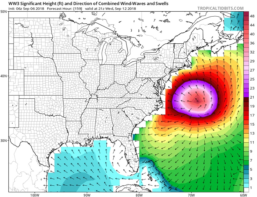
Whether or not Florence makes landfall, it is likely to send increasingly high waves and swells toward the mid-Atlantic and Northeast U.S. as soon as this weekend. These conditions could persist and intensify for several days into next week, depending on Florence’s track, which means an increasing threat of beach erosion and coastal flooding.
 |
| Figure 3. Predicted wave heights for 5 pm EDT Wednesday, September 12, 2018, from the 6z (2 am EDT) Thursday run of the WaveWatch III model. This model, which uses the GFS model as input, predicts that large swells from Hurricane Florence will begin impacting the U.S. East Coast from North Carolina to Massachusetts beginning on Sunday. Waves as high as 40 feet are predicted for the offshore waters of the Mid-Atlantic by Wednesday, September 12. Image credit: Levi Cowan, tropicaltidbits.com. |
The bottom line: Florence is nearly a week away from any potential U.S. landfall, so now is an excellent time for residents of the East Coast to make any of their seasonal hurricane preparations that haven’t yet been taken care of. Residents of Bermuda should be ready for the possibility of hurricane impacts as soon as Monday.
We’ll be back later today with an update on the Pacific, including Hurricane Olivia and its potential to affect Hawaii next week.
Dr. Jeff Masters contributed to this post.


