| Above: Forecast of surface pressure (in millibars) and surface winds (in knots; multiply by 1.15 for mph) from the 12Z Friday run of the GFS forecast model, valid at 7 pm EST Saturday, November 16, 2019. Image credit: tropicaltidbits.com. |
A coastal low moving slowly offshore this weekend could bring high-impact winds, rain and storm surge to eastern North Carolina, with minor to moderate coastal flooding along much of the East Coast. Meanwhile, Tropical Storm Raymond in the Northeast Pacific will push slowly toward Baja California this weekend. Raymond may inject moisture next week into a strong upper low that will bring much-needed rain and mountain snow from southeast California into the southern Rockies.
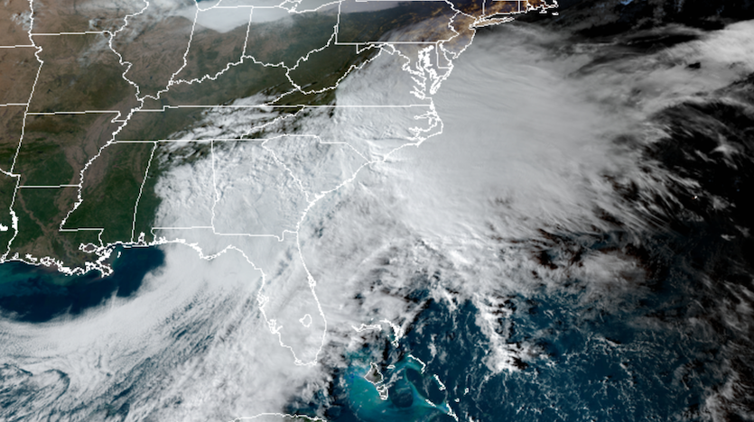
The coastal low was gaining strength on Friday afternoon about 100 miles east of the Georgia coast, in tandem with a compact upper low across the Deep South largely cut off from the jet stream and drifting eastward. By Saturday, the surface and upper lows will come into close alignment just southeast of the Outer Banks of North Carolina. After holding in place for much of the weekend, the entire complex will pivot northeastward by Monday ahead of a much broader upper-level trough. A swath of freezing rain could develop over New England early Monday as the low accelerates northeastward, still holding offshore.
 |
| Figure 1. GeoColor satellite image of the complex Southeast U.S. storm taking shape at 2040Z (3:40 pm EST) Friday, November 15, 2019. Image credit: RAMMB/CIRA/CSU. |
All this adds up to a weekend dominated by raw, gloomy weather for much of the coastal Southeast and mid-Atlantic. Eastern North Carolina is in for the worst of it. Prolonged east to northeast surface winds will push water against the Outer Banks and into the rivers and inlets of Pamlico Sound. Inundations of 2 to 4 feet are possible, especially in the Outer Banks. The National Weather Service in Newport/Morehead City predicts that wind gusts could be in the range of 50-60 mph over and near Pamlico Sound and as high as 70-80 mph along the Outer Banks. Wave heights could reach 5-7 feet even within Pamlico Sound, and 20 feet or more just offshore.
Computer models are still struggling to depict the precise evolution of the surface low, and its exact track and strength will largely determine the severity of the impacts. Still, there is increasing confidence in a high-impact, nor’easter-type storm.
 |
| Figure 2. Peak wave heights this weekend predicted from the Southeast storm as of 5 am EST Friday, November 15, 2019. Image credit: NWS Newport/Morehead City. |
Ocean overwash is the biggest threat, according to the NWS. “In some areas on the oceanfront north of Cape Hatteras, battering waves will cause damage to property,” said the office in a forecast discussion on Friday afternoon. “Numerous roads will be impassable under several feet of water and vehicles will be submerged. Some neighborhoods will be isolated and some areas may need to be evacuated.” Some soundside flooding is possible across Hatteras and Ocracoke Islands, Downeast Carteret County, and the Lower Neuse River, they added.
Moderate coastal flooding is expected further north along the mid-Atlantic coast, including Chesapeake and Delaware Bays, with inundations mainly in the 1-to-2-foot range. Similar flooding could extend to the east-facing coastlines of New England by Monday.
One upside of the storm is the soaking rains already developing across much of Georgia and South Carolina, where moderate to severe drought has become widespread. The mostly-moderate rainfall rates and pre-existing dryness will keep the inland flood threat limited. Closest to the storm center, over far eastern North Carolina, rainfall totals of 3” – 7” are possible.
See the weather.com writeup for frequent updates on this coastal storm.
 |
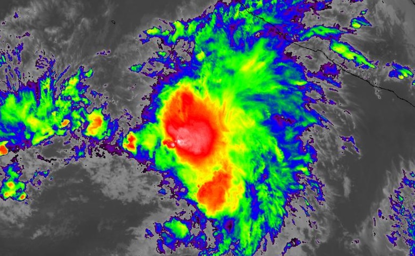
| Figure 3. Infrared image of Tropical Storm Raymond at 2240Z (5:40 pm EST) Friday, November 15, 2019. Image credit: NASA/MSFC Earth Science Branch. |
Tropical Storm Raymond and a potent midlatitude storm to converge on the Southwest U.S.
Odds are increasing for some welcome moisture to arrive later next week across the drought-stricken Southwest. Computer models are coming into agreement that a weak upper low will pinch off west of Baja California this weekend, to be followed by a large, strong upper low that dives into the Southwest around midweek, then heads slowly eastward. If the timing unfolds as predicted, this major low will absorb the weaker low and pull moisture from the remnants of Tropical Storm Raymond northward into Arizona.
Model ensembles suggest that rainfall next week could total around 0.5” in Yuma to 1.5-2.0” in Phoenix, according to the NWS Phoenix office, with larger amounts possible in terrain-favored areas toward northern Arizona. Such totals would be several times the average amount of rain that falls during the entire month of November. Ample rain and mountain snow can be expected over much of Utah, Colorado, and New Mexico if this pattern takes shape. The storm could provide broad relief for the Four Corners area, which is enmeshed in severe drought, and help bolster early-season snowpack across the Southern Rockies. There’s more uncertainty across southern California, where the amount and location of any rainfall will hinge more tightly on the track and timing of the upper-level storm.
This weekend weather looks nice! A series of storms will bring cooler and wet weather from Tuesday night through Friday. Here is a rainfall total estimate for next week. #azwx pic.twitter.com/i2omtYvTuK
— NWS Flagstaff (@NWSFlagstaff) November 15, 2019
More than 500 miles south of Cabo San Lucas, Raymond became the 18th named storm of the East Pacific season at 10 am EST Friday. By 2 pm EST, its top winds had increased to 50 mph. Raymond was moving north-northwest at 7 mph, and it may strengthen a bit more before fast-intensifying wind shear begins taking its toll on Saturday.


