| Above: This natural-color image from the Himiwari-8 satellite shows Tropical Cyclone Fani approaching the coast of northeast India at 2030Z Thursday, May 2, 2019 (2 am Friday IST). Image credit: RAMMB/Colorado State University. |
Down from its peak of 155-mph sustained winds—but still a potentially catastrophic storm—Tropical Cyclone Fani muscled its way into India’s Odisha state on Friday morning local time (IST), moving slowly onshore along a track that partially paralleled the coast. Fani’s northwest eyewall began nudging onshore around 8 am IST Friday, according to the India Meteorology Department. IMD reported that the eye came ashore near the city of Puri between 8 and 10 am IST, with Fani's center located just inland a few miles west of Puri at around 9:30 am. At 7:30 am, Puri reported sustained winds of 88 mph with gusts to 108 mph.
 |
| Figure 1. Radar image from Gopalpur, India, showing the eye of Tropical Cyclone Fani as the eye was moving onto the coast of Odisha state near Puri at 0335Z (9:05 am IST) Friday, May 3, 2019. Image credit: IMD. |
Satellite imagery suggests that Fani may have topped out at Category 5 strength on Thursday, above the official estimate of a top-end Cat 4. As of 0Z Friday (5:30 am IST), Fani’s top sustained winds had dropped to 150 mph, according to the Joint Typhoon Warning Center, implying a landfall intensity that was probably in the Category 4 range. Satellite imagery suggested a greater weakening may have occured, and the strongest winds reaching the coast north and east of Fani’s eye may end up below the JTWC’s 0Z peak intensity, perhaps topping out in the Category 3 or low Cat 4 range. Such winds are still capable of major destruction, especially to homes made of thatch, mud, and leaves.
Storm surge a serious threat well northeast of Fani's landfall
Storm surge remains a major concern as Fani sidles inland. Because of its shore-paralleling track, the center is expected to remain within 20 miles of the coast for almost 24 hours after landfall. This track will keep much of the circulation over water, thus keeping Fani from weakening as fast as a storm moving farther inland would.
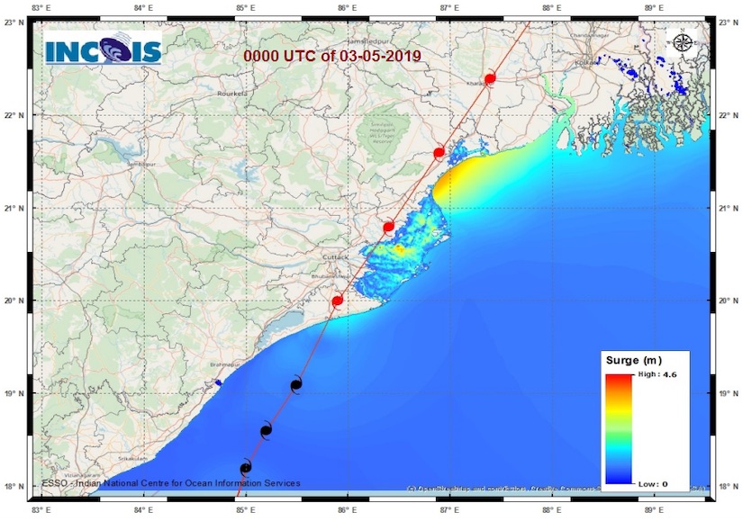
The official IMD forecast called for a surge topping out at 1.5 meters (4.9 feet). However, Fani’s vaulting to high-end Cat 4 strength indicates that the peak landfall surge near and just east of Puri could have been higher in some locations. Updated surge guidance issued at 0Z Friday by the India National Center for Ocean Information Services (see Figure 1) shows the potential for around 4 meters (13 feet) of storm surge atop astronomical tides along the concave coast of far northeast Odisha state, including areas near Balasore. South of that stretch of coastline, most of the area east of Fani's track is predicted to be inundated by several feet of surge.
 |
| Figure 1. Storm surge from Tropical Cyclone Fani (in meters) projected by 0Z Friday model guidance from the India National Center for Ocean Information Services. Image credit: INCOIS. |
By 0Z Saturday (early Saturday morning local time), Fani is predicted by JTWC to be just west of Kolkata as a minimal Category 1 cyclone. Even if Fani has already weakened to tropical-storm strength by that point, we can expect the broad offshore wind field to continue pushing water northeastward toward the surge-vulnerable Ganges Delta. The riverine channels and swamps of the delta may allow significant surge, perhaps as much as 2 meters (6.6 feet) to extend well inland toward Kolkata, which adjoins the Houghty River. The huge tidal range in Kolkata—about 10.1 feet—suggests that any surge impacts would be most evident around high tide, which occurs at 12:45 pm Friday and 1:01 am Saturday local time. Some surge may also extend into southwest parts of Bangladesh.
Especially if Fani’s winds are slow to decrease, major wind damage could occur well north of the landfall point, especially across the area east of Puri’s path—the districts of eastern Puri, Jagatsinghpur, Kendrapara, and Bhadrak in Odisha state. It may take several days to assess the full extent of Fani’s damage in the more remote villages of this region. Even as far north as Kolkata, sustained tropical-storm-force winds are quite possible, which could cause widespread problems for the metropolitan area of 14 million.
Torrential rains are still expected along Fani’s path, especially over northeast Odisha state. Northeast India is accustomed to very heavy rain during the summer monsoon, but such rains could exacerbate surge-related flooding. Intense rains moved into the Kolkata area on Friday morning well ahead of Fani’s core. Kolkata is famously flood-prone, as we discussed in Thursday morning’s Category 6 post, and any heavy rainfall raises the risk of combining with storm surge to produce compound flooding in the near-coastal zone.
See the frequently updated weather.com article for more on Fani's impacts as news comes in.


