| Above: An entire neighborhood between 40th Street and 42nd Street in Mexico Beach, Fla. was wiped out by Hurricane Michael on Wednesday, Oct. 10, 2018, as shown in this aerial shot from Thursday, Oct. 12. The devastation inflicted by Hurricane Michael came into focus Thursday with rows upon rows of homes found smashed to pieces, and rescue crews began making their way into the stricken areas in hopes of accounting for hundreds of people who may have stayed behind. (Michael Snyder/Northwest Florida Daily News via AP) |
Hurricane Michael is no more. The National Hurricane Center wrote their final advisory on Michael at 5 am Friday, when the catastrophic storm had transitioned to a powerful extratropical storm with 65 mph winds that was rushing northeastward out to sea. Overnight, the demon storm caused more destruction, notably in Virginia, where the storm’s torrential rains caused flash floods that claimed at least five lives. There were at least 114 reports of flash flooding in Virginia from Michael, and 46 in North Carolina, where soils were still saturated from the records rains of Hurricane Florence two weeks ago. Seven states reported at least 5 inches of rain from Michael.
Here are some notable rainfall totals by state, as tabulated by weather.com:
- Florida: 5.26 inches at Sumatra; 3.17 inches in Tallahassee; 2.61 inches in Panama City
- Alabama: 5.33 inches near Rehobeth; 4.92 inches in Dothan; 1.60 inches in Montgomery
- Georgia: 6.48 inches near Powder Springs; 3.37 inches in Macon
- South Carolina: 7.39 inches near Jefferson; 4.98 inches in Columbia; 4.75 inches in Greenville/Spartanburg
- North Carolina: 9.62 inches near Black Mountain; 6.75 inches near Boone; 2.95 inches in Asheville
- Virginia: 8.04 inches in Bowling Green; 5.40 inches in Farmville; 5.05 inches in Danville
- Maryland: 7.10 inches in Salisbury; 2.43 inches in Annapolis
- Delaware: 3.83 inches in Georgetown; 1.85 inches in Dover
- New Jersey: 3.03 inches in Millville; 2.58 inches in Atlantic City (airport)
- New York: 2.29 inches in Islip; 1.43 inches at JFK Airport
Ex-Michael was delivering a parting shot of heavy rains to southern New England late Friday morning, with over 3 inches of rain reported on Martha's Vineyard, Massachusetts, according to the National Weather Service. By early afternoon, Michael’s rains were spreading over Canada's Maritime Provinces, and the remains of Michael could even affect Spain and Portugal next week (see below).
Crazy video: floodwaters pushed open the front doors of Supply Resources in Danville. The owner showed us inside as he was cleaning up. Everything is caked in mud and destroyed. pic.twitter.com/BIBXHPQaIk
— Siobhan McGirl WDBJ7 (@siobhan_mcgirl) October 12, 2018
Crazy video: floodwaters pushed open the front doors of Supply Resources in Danville. The owner showed us inside as he was cleaning up. Everything is caked in mud and destroyed. pic.twitter.com/BIBXHPQaIk
— Siobhan McGirl WDBJ7 (@siobhan_mcgirl) October 12, 2018Incredible destruction in the Florida Panhandle
Search and rescue and recovery efforts continue in the Florida Panhandle, where Michael made landfall as a 155 mph Category 4 hurricane—the strongest ever recorded in the Panhandle, and the fourth strongest landfalling hurricane in mainland U.S. history. So far, none of the 13 deaths being blamed on the hurricane are in the landfall zone; all occurred well inland, due to flash floods, falling trees, and automobile accidents. Fatalities may still be discovered in the landfall zone, though.
While the low death toll so far can be partially attributed to good forecasts and evacuations efforts, it is also partially due to luck, since hundreds of people in the hardest-hit Mexico Beach region rode out the storm. I heard one survivor tell the tale of how she and a companion were caught in Michael’s dangerous 8 – 14’ storm surge and swam through the churning debris to another home while wearing life jackets.
For such a high-impact storm, Hurricane Michael’s life as a tropical cyclone was remarkably short. First tracked by NHC as a potential tropical cyclone, Michael became a tropical depression at 5 am EDT Sunday, October 7. It became a named storm at 12:55 pm EDT Sunday and a hurricane at 11 am EDT Monday, just a little more than two days before it crashed ashore in the Florida Panhandle. NHC officially declared Michael non-tropical at 5 am EDT Friday, marking an end to its short life—less than five days—as a tropical cyclone.
For more on Michael’s damage and impacts, see the frequently updated weather.com stories.
Western Caribbean development looking less likely next week
Models are predicting that a broad area of low pressure will form over the west-central Caribbean Sea this weekend. This system is predicted to move slowly westward toward Central America early next week, and moderate wind shear and very warm ocean temperatures could allow some slow development before the system moves over Nicaragua and Honduras by Tuesday. This system has had decreasing model support in recent runs, resulting in NHC significantly dropping their forecast odds of development. In their 8 am EDT Friday Tropical Weather Outlook, NHC gave this future low 2-day and 5-day odds of development of 0% and 20%, respectively. Development of this low may be more likely in the Eastern Pacific by the middle of next week, after it crosses over Central America into the Pacific.
Sergio rolls into Baja California
Tropical Storm Sergio was rolling across Mexico’s Sea of Cortez (Gulf of California) on Friday morning, after making landfall near Los Castros on the Baja Peninsula at around 7 am EDT with top sustained winds of 45 – 50 mph. NHC reported that winds gusted to 60 mph at a Mexican Navy automatic weather station in the Port of Santa Rosalia and to 52 mph at Guaymas, on the west coast of mainland Mexico. By Friday evening, Sergio will be a remnant low racing through northwest Mexico. Rain totals as high as 8” could be notched in the Mexican state of Sonora. Sergio’s remnants will roll across Texas and Oklahoma on Saturday, perhaps dropping 1” – 3” of rain in the Red River area of southern OK and northern TX.
 |
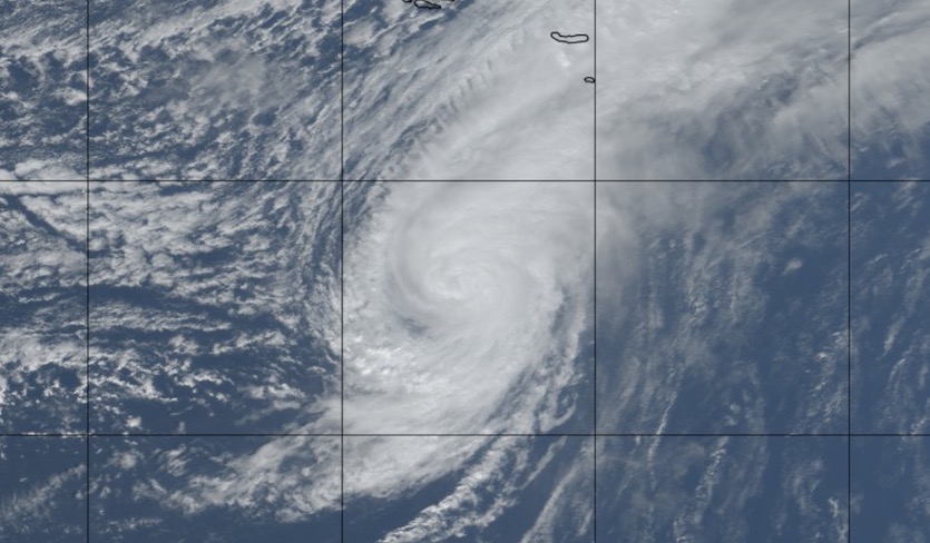
| Figure 1. Natural-color satellite image of Hurricane Leslie at 1450Z (10:50 am EDT) Friday, October 12, 2018. The Azores can be seen outlined north of Leslie. Image credit: tropicaltidbits.com. |
Leslie heading toward Madeira and the Portugal mainland
After days of loitering across the central North Atlantic, Hurricane Leslie is now en route to a potentially historic landfall on the Iberian Peninsula. Almost three weeks after being named, Leslie is now close to the top of its game: its top sustained winds were 85 mph as of 11 am EDT Friday, down only slightly from an overnight peak of 90 mph. Leslie’s long tenure has enabled it to build up a large wind field: tropical-storm-force winds extend out up to 230 miles from its center, and hurricane-force winds extend up to 70 miles out.
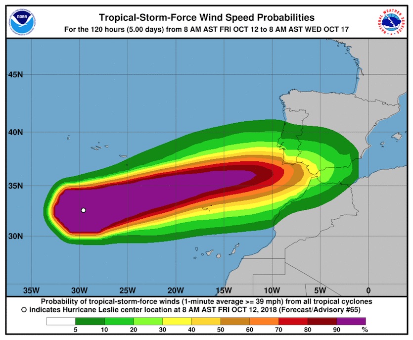
A strong midlatitude jet is hauling Leslie east toward the Iberian peninsula. After days of huge uncertainty, our top track models finally came into solid agreement early Friday that Leslie will continue tracking toward Spain and Portugal, but there is still model disagreement on the time of arrival and the landfall location. NHC expects that Leslie will be in the process of evolving into a strong post-tropical storm by the time it reaches the Iberian Peninsula, but its notes that Leslie may be moving more quickly and may arrive further north than its current forecast.
The NHC outlook agrees closely with the 00Z European model run and the 06Z Friday HWRF run; the latter brought Leslie very near the Strait of Gibraltar early Monday with top winds of around 60 mph affecting far northern Morocco. The 12Z HMON model—like the HWRF, one of our highest-resolution models—shows a powerful Leslie reaching the coast of Portugal just south of Lisbon in the predawn hours with top winds of 60 - 70 mph. The 12Z run of the GFS model was even faster, with a 981-mb Leslie crashing ashore near Lisbon shortly after midnight Saturday night. Similarly, the 12Z HWRF model shows landfall just south of Lisbon not long after midnight, with top winds above minimal hurricane strength. The ICON-EU model run from 06Z Monday, posted on the website Severe Weather Europe, depicts wind gusts of more than 75 mph moving across central Portugal early Sunday. Leslie’s heaviest rains will be limited to the immediate landfall area, where amounts could total 2” – 3”.
NHC’s 11 am advisory on Leslie includes the kind of statement you don’t see often: “Interests in Portugal and Spain should monitor the progress of Leslie.”
 |
| Figure 2. Probability of experiencing tropical-storm-force winds (sustained 39 mph or more) from Leslie over the next five days, starting at 8 am EDT Friday, October 12, 2018. Image credit: NHC. |
Since the 1842 Spanish hurricane, only one tropical cyclone from the Atlantic has been recorded on the Iberian peninsula: Tropical Storm Vince. Developing near the tail end of the hyperactive 2005 season, Vince made landfall on October 11 as a tropical depression on the south coast of Spain, near Huelva, not far from the landfall location of the 1842 storm. Winds reportedly gusted to 48 mph at Jerez. Even later in that wild 2005 season, on November 28, Tropical Storm Delta made a damaging pass through the Canary Islands with 70-mph winds while evolving into a post-tropical cyclone, then made landfall in Morocco with top sustained winds of close to 60 mph.
The remnants of Hurricane Michael could swing south into the far northwest part of the Iberian Peninsula on Monday, as indicated by the GFS and European models, but any impacts should be relatively minor.
#Hurricane #Leslie has left an impressive cold wake in its path as it has slowly traversed virtually the entire subtropical North Atlantic. pic.twitter.com/ZORsJsPh2z
— Philip Klotzbach (@philklotzbach) October 11, 2018
Luban heading toward a Yemen landfall
Tropical Cyclone Luban continued heading westward through the Arabian Sea on Friday as a weakening tropical storm. The Joint Typhoon Warning Center predicts that Luban will regain some strength over very warm waters as it rolls toward the Arabian Peninsula, with a landfall at close to hurricane strength expected on the southeast coast of Yemen late Sunday. The HWRF model, our top performer for intensity in the Atlantic in 2017, calls for Luban to reach the coast on Sunday with peak winds of 70 – 75 mph.
Only a few tropical cyclones have been known to reach the Yemen coast. In 2015, Cyclone Chapala became the first hurricane-strength cyclone on record for Yemen.
Jeff Masters co-wrote this post. He'll have a new post this afternoon: Dangerous Rapidly Intensifying Landfalling Hurricanes Like Michael and Harvey May Grow More Common.


