| Above: Infrared satellite image of tropical storms Erick (left) and Flossie (right) at 2145Z (5:45 pm EDT) Monday, July 29, 2019. Image credit: NASA/MSFC Earth Science Branch. |
Two well-organized tropical storms are on track to become potent hurricanes as they head from the Eastern toward the Central Pacific. Hawaiians should keep an eye on both, although the second one—Flossie—appears to be the main concern. Meanwhile, the Atlantic continues to percolate with tropical waves that aren’t managing to organize into full-fledged cyclones just yet.
 |
| Figure 1. Natural-color satellite image of Tropical Storm Eric at 2205Z (6:05 pm EDT) Monday, July 29, 2019. Image credit: tropicaltidbits.com. |
Tropical Storm Erick, located about 1200 miles east-southeast of Hilo, Hawaii, continues to track west-northwest at 16 mph. As of 5 pm EDT Monday, Erick’s top sustained winds were holding at 70 mph, just shy of hurricane strength. Erick’s core convection (showers and thunderstorms) remained compact on Monday, with limited convection beyond the core. Erick is surrounded by moderately dry air (mid-level relative humidity of 60%), which could be hindering more rapid growth. The storm has ample upper-level outflow, however, and wind shear will remain light to moderate (5-15 knots) for the next couple of days. Erick’s steady west-northwest track will take the storm over sea surface temperatures (SSTs) of 27-28°C (81-82°F), which are more than warm enough for development.
 |
| Figure 2. WU depiction of NHC forecast track for Tropical Storm Erick as of 5 pm EDT Monday, July 29, 2019. |
NHC predicts that Erick will peak as a Category 3 storm with top winds of 115 mph on Wednesday. The 12Z Monday runs of the high-resolution HWRF and HMON intensity models are roughly consistent, showing a chance of brief Category 3 strength by Wednesday. Later in the week, increasing wind shear and increasingly drier air will start to take their toll, and Erick should begin a gradual weakening trend.
Track models agree on taking Erick about 150 to 250 miles south of Hawaii around Friday. By that point, Erick will most likely be a weakening tropical storm.
 |
| Figure 3. Natural-color satellite image of Tropical Storm Flossie at 2105Z (5:05 pm EDT) Monday, July 29, 2019. Image credit: tropicaltidbits.com. |
Flossie: the more likely of the Pacific’s tropical twins to affect Hawaii
Tropical Storm Flossie will largely follow in Erick’s footsteps, though on a more northward-displaced track. Located about 830 miles south-southwest of Cabo San Lucas, Mexico, at 5 pm EDT Monday, Flossie was packing top sustained winds of 50 mph. Flossie is moving at a rapid clip—about 18 mph—on a westerly course that should become more west-northwest by midweek. Flossie’s main advantage over Erick is more moisture (mid-level relative humidity of 70-75%), which is helping the storm to maintain a more robust convective core. Wind shear has been nibbling at Flossie’s north side, however.
Flossie could see a spike of rapid intensification as it passes over warm waters (28-29°C or 82-84°F) through Wednesday, with light to moderate wind shear (5-15 knots). The 12Z Monday run of the DTOPS intensity model gives Flossie a 44% chance of reaching Category 3 strength by Wednesday. NHC predicts Flossie to peak at the top of the Category 2 range on Thursday, then embark on a slow weakening trend amid drier air. Wind shear will only gradually increase along Flossie’s track, and SSTs should remain above the 26°C benchmark, so Flossie may be slow to weaken.
 |
| Figure 4. WU depiction of NHC forecast track for Tropical Storm Flossie as of 5 pm EDT Monday, July 29, 2019. Hawaii is at far left. |
The long-range European and GFS track models have been very consistent for several days in bringing Flossie (or its remnants) close to Hawaii about a week from now. Given the consistency across models and time frames and the steady steering currents, we should take this as a plausible possibility, although only a slight wobble in track would keep Flossie clear of the islands. Historically, most tropical cyclones have dropped below hurricane strength when approaching the islands on a track like this one, as such storms typically encounter drier, more stable air when they move closer to Hawaii.
 |
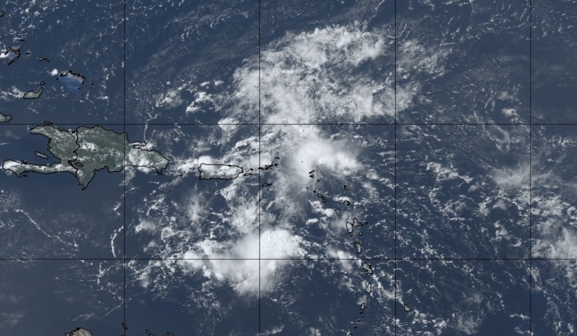
| Figure 5. Natural-color satellite image from 1845Z (2:45 pm EDT) Monday, July 29, 2019, shows disorganized 95L tracking over the northeast Caribbean. Image credit: tropicaltidbits.com. |
Struggling 95L could become more organized later this week
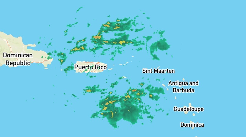
The wave known as Invest 95L weakened on Monday while traversing the northeast Caribbean, known as the “hurricane graveyard” for its tendency toward strong wind shear and dry air. Squally weather was increasing across eastern parts of the Greater Antilles, though. 95L could produce localized downpours as it moves across the Greater Antilles from Tuesday into Wednesday. A flash flood watch is in effect for Puerto Rico and the U.S. Virgin Islands through at least Tuesday night.
 |
| Figure 6. WU composite radar showed extensive showers and thunderstorms around Puerto Rico at 5:35 pm EDT Monday, July 29, 2019. |
Later in the week, 95L will approach the very warm waters of the western Bahamas. About 10% of the 12Z Monday GFS and European model runs showed development of 95L in this region late next week. In its tropical weather outlook issued at 2 pm EDT Monday, NHC gave the system a 10% chance of development in the vicinity of The Bahamas between Wednesday and Saturday.
 |
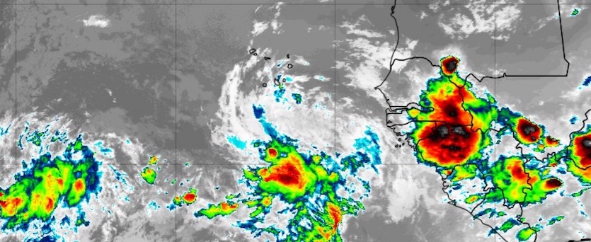
| Figure 7. Infrared satellite image of a tropical wave (center) several hundred miles west of the African coast at 2125Z (5:25 pm EDT) Monday, July 29, 2019. Image credit: tropicaltidbits.com. |
In the eastern Atlantic, the strong tropical wave that emerged from Africa on Sunday is suffering from ingestion of the dry Saharan air just to its north. Convection has diminished on the wave’s north side. The wave remains fairly well organized, though, and ensemble models indicate it has a modest chance of development later this week as it reaches warmer waters in the western part of the deep Atlantic tropics (the so-called main development region between the Caribbean and Africa). About 20% of European ensemble members, and about 50% of GFS members, develop this wave to at least some extent in the 3- to 5-day period. Any such development could affect the Leeward Islands about a week from now. Update: In its 8 pm EDT Monday tropical weather outlook, NHC gave this wave a near-20% chance of developing into at least a tropical depression in the central to western tropical Atlantic between Wednesday evening and Saturday evening.


