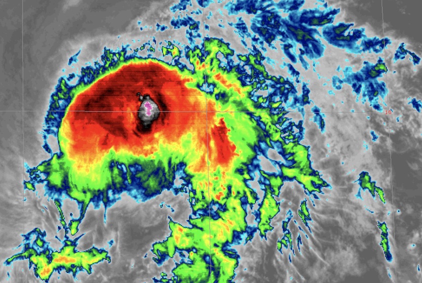
| Above: Infrared image of Hurricane Erick (left) and Tropical Storm Flossie (right) at 2250Z (6:50 pm EDT) Thursday, August 1, 2019. Image credit: NASA/MSFC Earth Science Branch. |
Uncertainties reigned supreme on Thursday in both the Atlantic and Northwest Pacific, with several systems showing potential for development but surrounded by question marks. Things were a bit more straightforward in the Central Pacific, where one hurricane and one tropical storm are on track to affect Hawaii over the next few days.
As of 5 pm EDT Thursday, Hurricane Erick was a Category 1 storm with 80-mph sustained winds, but satellite imagery revealed a heavily sheared storm on the decline, soon to be reflected in decreasing winds. Ever-increasing wind shear along Erick’s track (already 30-40 knots) will keep a steady weakening going, and Erick is expected to be a tropical depression by Monday.
Erick was located about 285 miles south-southeast of Hilo, Hawaii, moving west-northwest at 14 mph. Erick remains on a well-predicted course that will take its center about 150 miles south of the Big Island on Friday. A flash flood watch is in effect through Saturday morning for the Big Island, where enhanced upslope flow could lead to localized heavy rains of 4 – 8” or more, especially on east- and south-facing slopes. Exposed coastlines on the other Hawaiian islands will see pounding surf, and waves offshore could build to as high as 18 feet. Tropical-storm-force winds should remain south of the islands.
Hurricane #Erick is spreading clouds & ocean swells toward the Hawaiian Islands. Dangerous surf conditions are possible and heavy rainfall between 4 to 8 inches is forecast, with localized higher rain amounts. View more #GOESWest #HIwx imagery via https://t.co/7c1bZg7C60 pic.twitter.com/aW0ERSyq62
— UW-Madison CIMSS (@UWCIMSS) August 1, 2019
Next up for Hawaii is Tropical Storm Flossie, located about 1460 miles east of Hilo at 5 pm EDT with top sustained winds of 65 mph. For the last several days, Flossie’s west- to west-northwest track has been very well behaved and well predicted. If the current track and speed were to continue, Flossie would reach the Hawaiian Islands on Monday. The main question is whether a last-minute rightward turn, as predicted by some model runs, would prevent a landfall, or whether the storm will continue on its current heading and pass near or just north of the island chain. Most of the large-scale models recurve Flossie before landfall, but about 10% of the GFS and European model ensemble members move Flossie close to the island chain, as do the HWRF and HMON regional high-resolution models.
 |
| Figure 1. Infrared image of Tropical Storm Flossie at 2309Z (7:09 pm EDT) Thursday, August 1, 2019. Image credit: NASA/SPORT. |
Flossie briefly peaked as a Category 1 storm before weakening back to tropical storm status on Wednesday, with a somewhat bedraggled structure on satellite. A mix of nurturing and destructive influences—including sufficiently warm sea surface temperatures of 26-27°C (79-81°F) and moderate to strong wind shear (10-20 knots)—should allow Flossie to hold steady as a strong tropical storm for at least the next couple of days. Beyond that point, wind shear is expected to ramp up to the 25-35 knot range by Sunday, which will likely dent Flossie’s strength. There is widespread model agreement that Flossie will be a weak to moderately strong tropical storm by the time it makes its closest approach to Hawaii on Monday. Fortunately, the chances of hurricane strength by that point are very small.
Would think #Erick, possibly #Flossie, might take care of the small areas of "extreme" (D3) #drought on Maui and near the south point of the Big Island. Could be "too much of a good thing", though. pic.twitter.com/7yBOe5RiXB
— Jonathan Erdman (@wxjerdman) August 1, 2019
96L and a new wave simmering in the central Atlantic
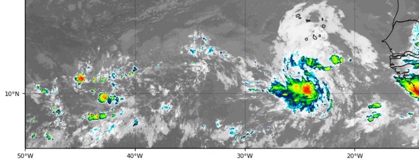
A tropical wave moving through the middle of the deep tropical Atlantic (a zone called the main development region) could become a tropical depression late this weekend or early next week as it approaches the Leeward Islands. In its 2 pm EDT tropical weather outlook, the National Hurricane Center gave this system 20% odds of development by Friday and 70% by Monday.
 |
| Figure 2. Infrared image of Invest 96L (left) and an unnamed tropical wave (right) at 2225Z (6:25 pm EDT) Thursday, August 1, 2019. Image credit: tropicaltidbits.com. |
On satellite, 96L wasn’t too impressive Thursday evening. The wave had just a smattering of showers and thunderstorms (convection), mainly well to the west of its broad center. The mid-level air around this wave is not particularly moist (relative humidity 55-60%). Otherwise, conditions should increasingly favor 96L over the next several days if it can form a healthy closed circulation. Wind shear will be dropping into the light to moderate range (5-15 knots) and water temperatures are quite warm (SSTs of around 28°C or 82°F).
The majority of GFS and European ensemble members from Thursday morning support 96L becoming at least a tropical depression and heading to the vicinity of the northern Leeward Islands by early next week. There’s much more uncertainty over what could happen then, as wind shear is likely to increase from a nearby TUTT (tropical upper tropospheric low) and the mid-level atmosphere may be drier. Only about 10-20% of the latest GFS and Euro ensemble members maintain 96L as a coherent cyclone past the Leewards, and the possible strengths and tracks vary wildly. The GFS, in particular, has backed off of longer-term development, a shift analyzed by Eric Webb and other experts in this Twitter thread.
ASCAT pass from this morning shows that the tropical wave behind #96L has a closed, yet very elongated LLC ~10N. While it likely won't amount to much, unlike #96L, its wave envelope is smaller & thus, may be able to more quickly take advantage of its environment in the E Atlantic pic.twitter.com/BOG3Yf7eIw
— Eric Webb (@webberweather) August 1, 2019
Although it’s not yet being tagged as an “invest”, the next wave behind 96L also bears watching. This disturbance has a compact but distinct weak surface low evident in ASCAT scatterometer data at around 11°N and 22°W. There is considerably more convection with this system that with 96L, along with a broad swath of moisture and cloudiness. Only a handful of the 70 GFS and Euro ensemble members develop this system, but that could change if 96L builds a stronger circulation. Smaller systems are especially prone to rapid strengthening (and weakening).
The wave formerly tracked as 95L has moved north of Hispaniola. It may produce squally weather in The Bahamas this weekend, but NHC gives it a near-zero chance of becoming a tropical cyclone this weekend east of Florida. The wave could strengthen as a nontropical low as it merges with a front and races northeast from the U.S. East Coast.
While two months of the Atlantic #hurricane season are now in the books, ~95% of all major (Category 3-5, max winds >=111 mph) hurricane activity has historically taken place after 1 August. pic.twitter.com/yAx8qPWUj5
— Philip Klotzbach (@philklotzbach) August 1, 2019
The Northwest Pacific awakens
After a protracted period of slumber—with only half the usual amount of activity this year so far and no typhoons since February—the Northwest Pacific is about to spit out two systems that could become land-threatening typhoons.
Minimal-strength Tropical Storm Wipha made landfall on Thursday in far southern China, drenching protestors in the Hong Kong area (about 200 miles to the northeast of landfall). Wipha’s remnants will be moving toward the northern Bay of Bengal early next week, possibly enhancing monsoon rainfall in that area.
Outside Eastern Magistrates Court in Sai Wan Ho, protesters awaiting the 44 people inside facing a judge over rioting charge...in T8 typhoon conditions pic.twitter.com/jY2tZAElUv
— Danny Lee (@JournoDannyAero) July 31, 2019
Tropical Depression 9W, which should soon be Tropical Storm Francisco, will intensify as it tracks over the open Northwest Pacific toward Japan. The Joint Typhoon Warning Center predicts that Francisco could strike southern Japan as a Category 1 strength typhoon early next week, in line with operational GFS and European model forecasts.
A disturbance called 94W may pose a bigger threat to East Asia later next week. Both the GFS and European model runs from 12Z Thursday develop 94W into a powerful typhoon that tracks north to northwest next week toward southern Japan. Models are divided on whether 94W might angle west or recurve north and northeast in the long range.


