| Above: Dry grass from a lack of rain sits beneath the Midtown skyline in Atlanta on Thursday, Oct. 3, 2019. Scientists say more than 45 million people across 14 Southern states are in the midst of a rapidly intensifying drought that's cracking farm soil, drying up ponds and raising the risk of wildfires. The dry ground has helped surface temperatures soar to record highs for early October. Image credit: AP Photo/David Goldman. |
Dozens of locations across the eastern half of the United States got their hottest October days on record this week in one of the most intense early-autumn heat waves in U.S. history. The October heat came on the heels of what was the hottest September on record in more than 50 U.S. locations, strewn across the nation from Hawaii and Alaska to Florida. We’ll have more on the September heat next week in our U.S. monthly climate roundup.
If this were a midwinter in our warming climate, a heat wave might have the bittersweet upside of at least feeling pleasant, but there’s no way to put a comfortable spin on this week’s misery. In many places, the multi-day heat wave produced temperatures that would have been scorching even for midsummer. For example, Reagan National Airport in Washington, D.C., soared to 98°F on Wednesday. As noted by Capital Weather Gang, almost half (40%) of all summers in the D.C. area since 1872 failed to get that hot on even a single day, much less on a day in October.
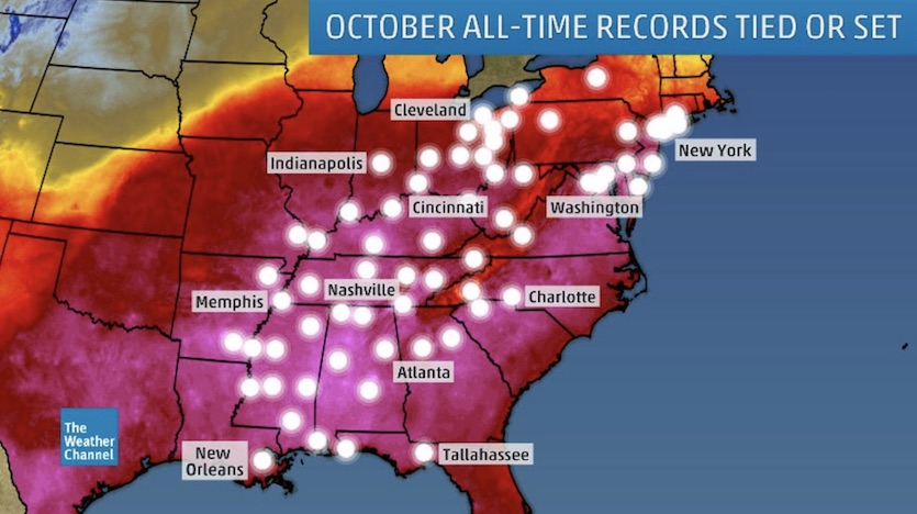
A weather.com compilation found 75 locations—stretching from the Deep South to the Ohio Valley, eastern Great Lakes, and Northeast—that either tied or set a new all-time October record high.
 |
| Figure 1. Locations that set all-time monthly record highs from Tuesday through Thursday, October 1-3, 2019. Image credit: weather.com. |
A number of southern locations reached the century mark (100°F) for the first time in any October. Tuscaloosa, Alabama, hit 100°F Tuesday and 101°F Wednesday and Thursday, the first triple-digit readings in city history for October. The same was true in Meridian, Mississippi, which did even “better”, hitting 101°F Tuesday and 102°F Wednesday and Thursday.
Tuscaloosa and Meridian are among the Southern cities that pulled off a rare and disconcerting hat trick: setting or tying all-time monthly record highs on three consecutive days. Here are the Tuesday, Wednesday, and Thursday temperatures for several of these unlucky spots:
Nashville, TN: 98°F, 99°F, 99°F (old record 94°F on Oct. 1, 1933; records start in 1873)
Knoxville, TN: 95°F, 96°F, 96°F (old record 94°F on Oct. 3, 1884; records start in 1871)
Chattanooga, TN: 97°F, 100°F, 100°F (old record 94°F on Oct. 5, 1954; records start in 1879)
Tallahassee, FL: 95°F, 96°F, 97°F (old record 95°F on Oct. 9, 1941, and Oct. 1, 1933; records start in 1892)
At least nine states set or tied their highest temperature for any October
Even more impressive than local heat records are state records—the highest temperatures ever reliably recorded anywhere in a particular state. The NOAA-based State Climate Extremes Committee (SCEC) does not keep track of monthly state temperature records, but a database maintained by WU weather historian Christopher Burt shows that a number of states appear to have set or tied their all-time record highs for October on either Tuesday or Wednesday. Below are the preliminary new records as compiled by Burt.
Alabama: 105°F at Marion on Oct. 2 and 3 (old record 103°F at Troy on Oct. 5, 1954)
*A reading of 106°F at Jasper on Oct. 3 appears questionable.
Florida: 101°F at Crestview on Oct. 3 (old record 100°F at Molino on Oct. 1, 1904; Orange City on Oct. 1 and 2, 1904; and Crestview on Oct. 1, 2019)
Mississippi: 102°F at Meridian on Oct. 2 and 3 (old record 101°F set at same site on Oct. 1, 2019; preceding record of 100°F set at six previous sites on different dates)
Delaware: 98°F at Wilmington on Oct. 2 (old record 97°F at Bridgeville on Oct. 5 and 6, 1941)
New Jersey: 97°F at Millville on Oct. 2 (ties same at Flemington and Tuckertown on Oct. 5, 1941)
New York State: 95°F at John F. Kennedy and LaGuardia airports on Oct. 2 (ties same at Danville on Oct. 2, 1927)
Tennessee: 100°F at Chattanooga on Oct. 2 and 3 (old record 99°F at three previous sites on different dates)
Kentucky: 98°F at Bowling Green and Kenlake Resort on Oct. 2 (ties 98°F set at three previous sites on different dates) .
Maryland : 101°F at Webster Naval Air Field on Oct. 2 (old record 99°F at three locations on different dates)
Washington, D.C.: 98°F on Oct. 2 (old record 96° on Oct. 5, 1941)
 |
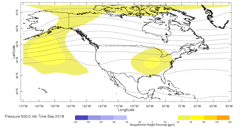
| Figure 2. Departures from the average height (in meters) of the 500 mb (500 hPa) surface, which is roughly the vertical midpoint of the atmosphere, for the month of September 2019. Higher 500-mb heights generally correspond to warmer low-level temperatures. Image credit: IRI. |
What’s up with this heat?
One of the main culprits behind the recent heat has been a persistent upper-level ridge across the eastern U.S. The ridge has not only fostered subsidence, which warms the atmosphere, but it has also pushed away rain-bearing systems from many parts of the South and East. Parched soil heats up more readily than wet soil, which allows the surface air to heat up as well.
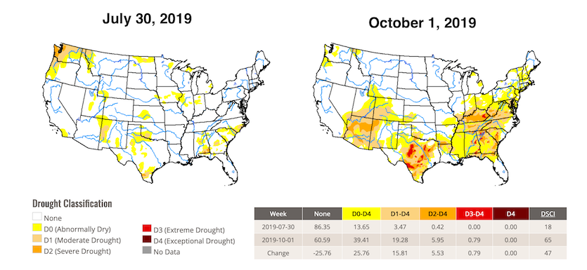
A number of locations that had their hottest September also had their driest, including Dallas-Fort Worth and New Orleans. The turn toward dry weather in recent weeks has been so sharp that much of the Southeast is now considered to be in a “flash drought".
 |
| Figure 3. Comparison of weekly U.S. Drought Monitor for July 30, 2019 (left) and October 1, 2019 (right) shows the rapid progression of drought across the south-central and southeast U.S. Image credit: National Drought Mitigation Center. |
In addition, human-produced climate change is exacerbating heat waves in a variety of ways, as catalogued in many peer-reviewed studies. While some of the most extreme all-time local and state records from the 1930s persist, as is often noted in social media, those temperatures were goosed by the specific and unique circumstances of the Dust Bowl. One line of research points to the 1930s U.S. heat as being largely the unfortunate product of a La Niña-related sea surface temperature pattern together with massive topsoil loss from the wholesale plowing of the Great Plains in the absence of soil conservation measures. It is risky to assume that still-standing 1930s heat records somehow mean that current and upcoming heat waves aren’t a serious concern. (See the excellent tweetstorm by Zeke Hausfather on this topic.)
 |
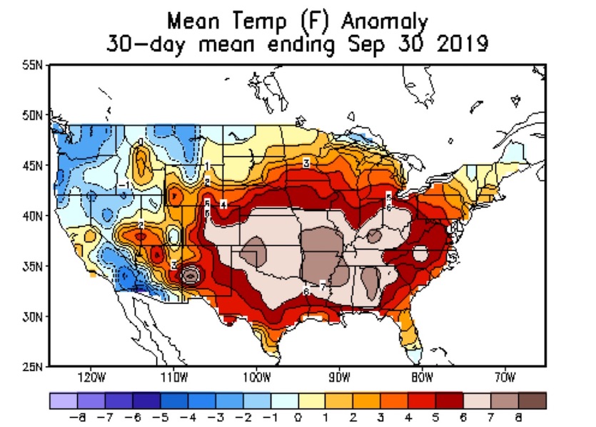
| Figure 4. Departures from the long-term average temperature observed in September 2019. A large swath from the Southern Plains to the Southeast was more than 6°F above normal for the entire month. Image credit: NOAA/NWS/CPC. |
A “cool”-down is on the way
Slowly but surely, relief is coming to areas hardest hit by the October heat wave. The transition was abrupt on Thursday in parts of the Northeast, where temperatures plummeted by up to 40°F in less than 24 hours. New York’s LaGuardia International Airport dropped from a scorching 95°F on Wednesday afternoon to a cool, rainy 55°F on Thursday morning.
This cool front will plow into the Southeast states, denting the torrid heat but leaving temperatures still above average for early October. A second, more potent front will sweep across the central and eastern U.S. early next week, finally pulling temperatures across the South into the vicinity of normal for this time of year.
Special thanks go to Jon Erdman (weather.com) and Christopher Burt for statistics used in this post.
And now, a weather haiku...
— NWS Nashville (@NWSNashville) October 4, 2019
It may be hot now
But check out Kansas City
50s are coming
...this is why we were science majors. pic.twitter.com/e8qRls3XI4


