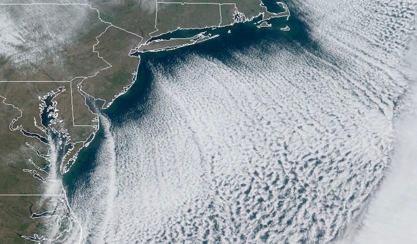
| Above: Cloud streamers develop across the Northwest Atlantic as cold surface air pours offshore atop warmer waters at 1600Z (11 am EST) Wednesday, November 13, 2019. Image credit: RAMMB/CIRA/CSU. |
The most widespread and intense cold of the autumn swept across the central and eastern United States early this week, bringing sharp winds and record lows. More than 300 record lows and record-low highs for the date were set from Monday to Wednesday morning, according to a compilation from Jonathan Erdman (weather.com).
Temperatures dipped below zero (–1°F) as far south as Garden City, Kansas, on Tuesday and De Graff, Ohio, on Wednesday, setting records for the date. The –1°F at Des Moines, Iowa, on Tuesday was the earliest below-zero reading in the city’s history outside of –3°F and –4°F on Nov. 7 and 8, 1991. Hibbing, Minnesota, plunged to –13°F on Tuesday; the only reading colder than that so early in any year was the –14°F on Nov. 7, 1991. Indianapolis fell into single digits five days earlier in the fall than ever observed in 149 years of recordkeeping, with a low of 8°F on Tuesday. The 8°F recorded in Watertown, New York, on Tuesday was its coldest temperature so early in the year in records going back to 1893. Watertown promptly outdid itself on Wednesday with a low of –7°F, tying the November record set just last year on Nov. 22 and 23.
It *looks like* the -7°F at Gouverneur 3 NW Coop, NY, and Watertown, NY, are the lowest temps in New York state this early in the season (at least since 1900). The previous earliest -7°F reading was Nov 14 in 1905 and in 1942. #nywx
— Brian Brettschneider (@Climatologist49) November 13, 2019
Some of the most impressive early-season cold was in the mid-Mississippi and Tennessee valleys. Tuesday was the earliest day on record with a high staying below 30°F in Nashville, TN (29°F); Paducah, KY (26°F); and Cape Girardeau, MO (25°F). Further north, Milwaukee, WI, had a high of just 19°F on Tuesday, two days earlier than any other sub-20°F low in the city’s 149 years of weather records.
Fun fact... It was as cold or colder this morning at all of our NWS automated (ASOS) sites than it was during all of last winter.#Novembrrrr #lawx #mswx pic.twitter.com/C81n8xHCsl
— NWS New Orleans (@NWSNewOrleans) November 13, 2019
There were multiple signs of the chilly air passing over still-mild bodies of water. Lake-effect snow and cloud streamers developed in the usual areas downwind of the Great Lakes, but also near much smaller bodies of water, including Lake Sakakawea on the Missouri River in North Dakota.
Sunrise on an active lake-effect snow day. I see these types of images every winter, and yet they never gets old. Simply beautiful pic.twitter.com/ubPtUnFYF2
— Greg Diamond (@gdimeweather) November 12, 2019
Lake effect (and river effect?) streamers in parts of Arkansas, Missouri, Tennessee region this morning with all the cold air spilling through the region. Some reports of snow from them. pic.twitter.com/tdr1RbNEw6
— Ian Livingston (@islivingston) November 12, 2019
Delaware and Chesapeake Bay effect snow and cloud streamers. #obx #ncwx #vawx pic.twitter.com/TxerBdijGA
— Brad Panovich (@wxbrad) November 13, 2019
Sea smoke—another product of cold air massing over relatively warm water—was seen this week in locations as far-flung as Duluth, Minnesota, and Pensacola, Florida.
STUNNING SEA SMOKE: Watch as the cold air moves over the relatively warmer waters of Lake Superior and creates the sea smoke as the sun rises this morning from 6:30am - 7:45am. Meteorologist @tdaytonwdio says it will be cold again today, but a warming trend is headed our way. pic.twitter.com/aiqxPnNUHv
— WDIO News (@wdiowirt) November 12, 2019
[twitter-embed-6]
[/twitter-embed-6]The sun is up with a better view of the sea smoke! Pensacola has hit 29 degrees which breaks the previous record of 30 that was previously set in 1911. #NWFL #flwx pic.twitter.com/kZf8VBy3hS
— Kaitlin Wright (@wxkaitlin) November 13, 2019
Coastal storm could bring extended flooding along Southeast U.S. shores
As the cold surface high moves offshore, reinforced by a subsequent high across the Northeast, it will push northeast winds along the East Coast for several days. From Friday into Saturday, a strong surface low will wrap up along the residual front off the Southeast Coast and intensify the winds and seas pushing toward the coast. As upper-level energy feeds into the region, the low may strengthen further as it pulls northeastward away from the mid-Atlantic around Sunday and Monday. The result will be a prolonged and widespread bout of coastal flooding and beach erosion that may affect parts of the shoreline from New England to Florida. Heavy rains and high winds can be expected near the Southeast coast.
High tides related to the full moon will accentuate the tidal effects, especially over the next couple of days. Water levels at midday Wednesday were running around 2’ above normal at Fernandina Beach, FL, and Fort Pulaski, GA. Minor to moderate flooding is projected each morning from Thursday through at least Saturday at Charleston Harbor, SC. See the weather.com article for more details on this prolonged event; we’ll also have more later in this week here at Category 6.
 |
| Figure 1. People walk across the flooded St. Mark's Square, with the St. Mark's Basilica and the Bell Tower in background on Wednesday, November 13, 2019, after an exceptional overnight high tide on November 12. Tourists waded through flooded streets to seek shelter as a fierce wind whipped up waves in St. Mark's Square. Image credit: Marco Bertorello/AFP via Getty Images. |
Venice inundated by second-worst flood in centuries
The famed city of Venice, Italy—well acquainted with high water, especially during autumn storms in the Mediterranean—was socked with one of the worst floods in its history on Tuesday night. Water levels reached 187 centimeters (74 inches) at 10:50 pm local time Tuesday night, just 7 cm (3”) shy of the record set in a devastating 1966 flood. Some 85% of the city was flooded on Tuesday night.
As reported by Reuters, more than a meter (3 feet) of water poured across Saint Mark’s Square, a tourist landmark often inundated during “acqua alta” (high water) events in autumn. Much more concerning was the floodwaters that poured into the adjacent Saint Mark’s Basilica. The building had flooding just twice in the 1200 years leading up to the 21st century; it’s now been flooded four times in the last 20 years. Venice Mayor Luigi Brugnaro said the basilica had suffered “grave damage.” He added: "A high tide of 187 cm is going to leave an indelible wound.”
 |
| Figure 2. People assess damages in the flooded St. Mark's Basilica on November 13, 2019, after the high-tide flooding of November 12. Image credit: Marco Bertorello/AFP via Getty Images. |
Strong southeast flow up the Adriatic Sea teamed up with astronomical high tides associated with the full moon to trigger the flooding. The southeast flow was the result of a strong upper-level low and surface low over the Mediterranean, as well as a more compact “medicane” cyclone (a warm-core storm similar to a tropical cyclone) that came ashore in Algeria on Monday night. The larger storm absorbed the medicane’s remnants and energy on Tuesday.
As we discussed in a post last year, sea level rise associated with climate change has combined with local subsidence to put Venice at an ever-increasing risk of flooding. Tides in Venice are classified as “exceptional” when they exceed 140 cm (55.1"), which is enough to flood 59% of the city. According to City of Venice records, exceptional tides have occurred:
—only once from 1872 to 1950;
—about once every 5 to 10 years in the late 20th century;
—more than 10 times in just the last two decades, including this week’s event.
A set of 78 hinged, inflatable steel gates designed to protect the harbor and due to be completed by 2011 has fallen prey to a series of technical snafus and management scandals—including the arrest and indictment of the mayor of Venice—that pushed the expected opening day back until at least 2022. In a 2017 investigative report, “Venice and MOSE: story of a failure,” the Italian newspaper La Stampa called the project an “anthology of horrors.” Yale's Environment 360 website has an excellent feature on the MOSE project and its travails, written by Jeff Goodell—author of the must-read book The Water Will Come: Rising Seas, Sinking Cities, and the Remaking of the Civilized World.
More flooding was expected in Venice with the Wednesday-night high tide, and another powerful Mediterranean storm is looming on the horizon for this weekend.
For more on this week's Venice flooding, see the new post from Dr. Jeff Masters at Eye of the Storm (Scientific American).


