| Above: An Isle of Palms resident clears the drain on Hartnett Blvd. during Hurricane Dorian at the Isle of Palms, S.C., Thursday, Sept. 5, 2019, in Charleston, SC. Image credit: AP Photo/Mic Smith. |
Hurricane Dorian ground its way along the southern coast of North Carolina on Thursday night as a larger but thankfully much weaker storm than the Category 5 monster it once was. Dorian’s center will likely move onshore in the Morehead City/Cape Lookout vicinity during the predawn hours on Friday, then move across Pamlico Sound and into the open Atlantic on Friday. Dorian will then accelerate and slam headlong into Nova Scotia and Newfoundland this weekend as it transitions into a powerful extratropical storm with hurricane-force winds (see Canada's Weather Network for detailed coverage).
Dorian’s northern eyewall is on track to affect parts of the North Carolina coast from near Wilmington east to Morehead City, as well as the east-facing shores of southern Pamlico Sound. Much of the Outer Banks will experience the higher surge and stronger winds east of Dorian’s center. See the weather.com feature for more on Dorian’s numerous watches and warnings.
Given its size, Dorian has been slow to weaken, but it will likely be down to Category 1 strength by Friday morning. The only report of sustained hurricane-force wind onshore as of Thursday evening was a 77-mph sustained wind with a gust to 85 mph early Thursday afternoon at a Weatherflow station at Winyah Bay, South Carolina. Offshore in Dorian’s southern eyewall, NOAA buoy 41004 measured sustained winds of 85 mph and a gust to 98 mph around 3 pm EDT. Just before 8 pm, a buoy at Frying Pan Shoals reported a peak gust of 70 mph.
Here are the highest rainfall totals in each state from Dorian, as compiled by the NOAA/NWS Weather Prediction Center through 4 pm EDT Thursday:
South Carolina: 10.64” about 7 miles northeast of McClellanville
North Carolina: 5.95” at Wilmington International Airport
Florida: 5.68” about 4 miles south-southwest of Palm Coast
Georgia: 2.38” about 10 miles east of Savannah
Stiff onshore flow from the Atlantic blowing the Pamlico sound away from the western side of the Outer Banks. This is Rodanthe. #dorian pic.twitter.com/mw3odX0wsZ
— Mark Sudduth (@hurricanetrack) September 5, 2019
Storm surge flooding less than feared—so far
Dorian’s large circulation and strong winds have piled up a large storm surge, but so far, the highest surge heights in Florida, Georgia, and South Carolina have occurred closer to the time of low tide than high tide, which has limited storm surge damage and coastal flooding. Dorian’s winds have also been aligned more parallel to the shore than onshore, which has helped limit storm surge heights.
Storm surge flooding at Myrtle Beach during the Thursday afternoon high tide reached approximately 2.5’ above the high tide mark, and ranked in ninth place for the highest water level on record there. This was about 3.5’ below the water level of Hurricane Matthew of 2016, and more than 6’ below the record water level from Hurricane Hugo in 1989.
At Charleston, SC, the storm surge during this morning’s 1 am EDT high tide cycle was high enough to cause only moderate flooding and did not cause a top-ten highest water level on record. The peak storm surge of approximately 3.5’ came at the time of low tide, later in the morning. A surge of this level would have caused a top-five water level on record and major flooding, had it hit at high tide. The high tide in Charleston early Thursday afternoon brought only minor coastal flooding.
Another look at Ashley Avenue just outside @MUSChealth #chsnews #scnews #HurricaneDorian2019 #HurricaneDorain pic.twitter.com/2fW0VT3KTq
— MUSC Public Affairs and Media Relations (@MUSCPR) September 5, 2019
A storm surge of about 4.0’ hit Fort Pulaski, Georgia near the time of low tide on Wednesday, and water levels there stayed just below the moderate flooding threshold. Had Dorian’s peak storm surge coincided with high tide, it would have been the third highest water level on record--about a foot lower than the record set during Hurricane Matthew of 2016.
The highest water levels at Fernandina Beach, FL, near the Georgia border were 2.54’ above the high tide mark (called Mean Higher High Water, MHHW), ranking as the eighth highest on record (their record highest: 6.91’ in the October 1898 hurricane; second place was 4.13’ in Hurricane Matthew of 2016).
 |
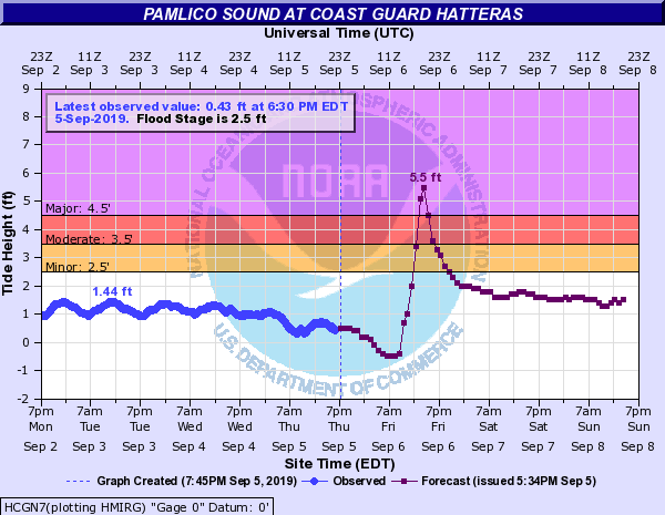
| Figure 1. Predicted water levels at Cape Hatteras, NC, on the Pamlico Sound side of the barrier island. Major coastal flooding is predicted for Friday afternoon, due to Dorian’s storm surge. The predicted level of 5.5’ would rank as the second highest in the short record of this station, behind Hurricane Matthew of 2016. Image credit: NOAA. |
 |
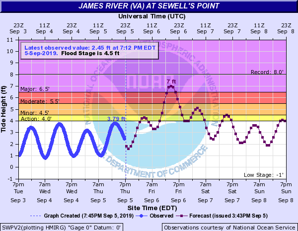
| Figure 3. Predicted water levels at Sewell’s Point near Norfolk, Virginia. Major coastal flooding is predicted for Friday afternoon. The predicted level of 7’ would rank as the fifth highest on record, 1’ below the record set in the 1933 hurricane. Image credit: NOAA. |
Major storm surge flooding predicted for Friday afternoon in NC, VA
Dorian’s storm surge is expected to cause major flooding along much of the North Carolina and Virginia coasts during the Friday high tide cycles. In their 8 pm EDT Thursday Dorian advisory, NHC called for coastal storm surge flooding of up to 4 – 7 feet above the high tide mark from Cape Fear, NC to Duck, NC, and 2 – 4 feet from Duck, NC to Poquoson, VA—including the Norfolk/Hampton Roads region. The storm surge during the Friday afternoon high tide cycle at Sewell’s Point, Virginia, near Norfolk, is predicted to bring water levels just 1’ below the all-time record set in the 1933 hurricane--the highest water since 2011.
Further northeast, rip tides and swells up to 12 feet high will slam into Long Island and the southern coast of New England. New York City will be closing its beaches on Friday and Saturday.
Mini-supercells along Dorian’s rainbands dropped tornadoes across coastal North and South Carolina. Since 4 am Thursday, at least 24 tornado reports were received by the NOAA/NWS Storm Prediction Center. The most destructive twister damaged dozens of campers and manufactured homes in the Boardwalk RV Park in Emerald Isle, NC, around 9 am EDT.
GOOSEBUMPS. This video is- wow. Just listen to that wind. It's from Jason Sawyer's Ring doorbell and it shows the moment a tornado destroyed his #EmeraldIsle home #HurricaneDorian #wral @WRAL pic.twitter.com/rYaXm77C8t
— Rosalia Fodera (@WRALRosalia) September 5, 2019
Typhoon Lingling heads for Korea
There is plenty of activity across the Northern Hemisphere tropics. Most of these systems are of no immediate concern, except for Typhoon Lingling, now a Category 4 storm with 140-mph sustained winds rampaging northward across the Northwest Pacific. Lingling will move about 100 miles west of South Korea on Saturday before slamming into North Korea on Saturday evening. "Record-breaking winds will be seen at islands and southern and western coastal areas," warned the Korea Meteorological Administration, as reported by the Korea Herald. Torrential rains could exceed 10" in far western North Korea and adjacent parts of China, especially where Lingling pushes upslope into mountainous terrain.
One other system in the tropics deserves special mention: Tropical Storm Akoni, christened in the Central Pacific on Thursday. Akoni will gradually strengthen over open water for the foreseeable future, passing well south of Hawaii. Akoni is the first name that's been re-used in the 39-year history of the current Central Pacific naming scheme. Many systems move into this region after having already been named in the Eastern Pacific, so the Central Pacific only uses about one storm name a year on average.
The current four lists of names (12 names per list) are worked through one by one, starting the next year where the previous year left off. These names were introduced in 1981, but the first name on the first list, Akoni, wasn't used till 1982. See this article for more on how the current lists came to be. Thanks to WU member Nathan (@AstrometeorWx) for calling attention to this tidbit, which was first shared on Twitter by Cody Fields (@wxtrackercody).
Dr. Jeff Masters co-wrote this post.


