| Above: This still image taken from video provided by Chris Higgins shows a tornado on Wednesday evening, May 22, 2019, in Carl Junction, Missouri. The tornado caused some damage in the town, located several miles northwest of the Joplin airport. Image credit: Chris Higgins via AP. |
The core of Jefferson City, Missouri, received a direct hit just before midnight Wednesday night from what the National Weather Service in St. Louis called a “violent” tornado. Posts on the NWS/St. Louis Facebook page late Wednesday night showed widespread structural damage. In an early-morning press conference, Jefferson City Police Lieutenant David Williams said that there were no confirmed fatalities but there were injuries and multiple reports of people trapped.
It appears the tornado moved northeastward close to U.S. Highway 54 through the heart of Jefferson City.
@lookner #Jeffersoncity #mowx Here is a rough estimation based on damage reports from the Fire scanner. Worst case scenario. pic.twitter.com/Jjrjcnnfqj
— Tim (@MurkyWanders) May 23, 2019
The NWS issued a tornado emergency as the tornado moved overhead.
Debris from the Jefferson City tornado is still falling out of the storm after half an hour and about 20 miles downstream. pic.twitter.com/9KJUa7nFyl
— Dennis Mersereau (@wxdam) May 23, 2019
The tornado was just one of a swarm that developed in a band from northeast Oklahoma through Missouri on Wednesday afternoon and evening. As of early Thursday morning, the NOAA/NWS Storm Prediction Center had tallied 27 tornado reports since 7 am CDT Wednesday. This follows a preliminary total of 45 reports on Tuesday and 28 on Monday, which had originally been expected to be the most intense day of this week’s severe weather.
At least three people were reported killed in Golden City, Missouri, after a long-track tornado struck on Wednesday evening. Before reaching Golden City, what appears to have been the same tornado also moved just northwest of the Joplin Regional Airport. Extensive damage but no serious injuries were reported in Carl Junction, just north of Joplin. The sirens that went off in Joplin were an eerie reminder that Wednesday was the eight-year anniversary of the city’s tornado catastrophe from 2011—the deadliest single tornado to strike the U.S. in the modern era of watches and warnings.
More severe weather in the pipeline through the holiday weekend
The unusually intense and prolonged upper air pattern that’s led to the severe weather this week—including a cold late-spring upper low in the West and a building ridge in the East—will continue right through the Memorial Day weekend, as the low weakens only gradually.
 |
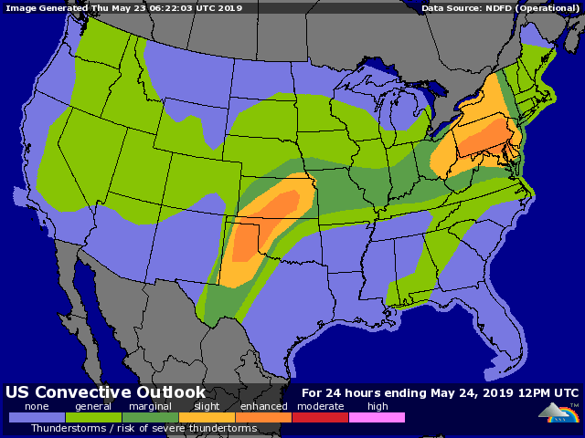
| Figure 1. Severe weather outlook issued early Thursday, May 23, 2019, valid through 7 am CDT Friday. |
Another sharp wave will emerge from the low on Thursday, which has prompted SPC to place the eastern Texas Panhandle, northwest Oklahoma, and south central Kansas under an enhanced risk for severe weather. Significant tornadoes and very large hail are possible near the dry line, especially in the Texas portion of the risk area, while high winds and heavy rains will sweep across much of Kansas. There is also an enhanced risk across southern Pennsylvania and northern Maryland, where thunderstorm lines and cells could bring damaging winds as they sweep toward the mid-Atlantic.
Entire town of Webbers Falls at risk
Things went from bad to worse on Wednesday for the small community of Webbers Falls (population about 600), which is poised precariously alongside the Arkansas River in east central Oklahoma. Residents were placed under a mandatory evacuation by Wednesday afternoon, based on the expectation that high water flowing down the storm-swelled Arkansas River was likely to inundate the town. Police officers told those who stayed to write their names on their arms so that they could be identified.
On Wednesday night, the situation escalated as two barges worked their way loose upstream near Muskogee. The barges were moving toward Lock and Dam #16 just north of Webbers Falls. Officials lost sight of the barges late Wednesday night, and the barges failed to reach the dam when expected—perhaps a sign that they ran aground. If the barges were to reach the dam, they could damage one or more gates; if they missed the dam, they could continue on and potentially reach the Interstate 40 bridge over the Arkansas River.
The line of vehicles blocked from crossing I-40 at Webbers Falls #oknews pic.twitter.com/HuQwXzerJl
— Brian Emfinger (@brianemfinger) May 23, 2019
On May 26, 2002—Sunday of Memorial Day weekend—a tugboat hauling two empty barges down the Arkansas went off course. The barges rammed a pier on the I-40 bridge at Webbers Falls, bringing down a 500-plus-foot section of the interstate in a disaster that killed 14 people and injured 11 others.
 |
| Figure 2. River forecast for the Arkansas River at Muskogee issued early Thursday, May 23, 2019. Image credit: NOAA/NWS/AHPS. |
As of early Thursday, the Arkansas River at Muskogee was predicted to crest on Saturday at 43.5 feet—the second highest crest on record at Muskogee, topped only by a 48.2’ crest on May 21, 1943. Widespread flooding is also expected upstream in the Tulsa area, where the Arkansas is predicted to reach its highest level since a devastating 1986 flood.
Many other waterways in northern Oklahoma, southern Kansas, and southwest Missouri are being affected by both thunderstorm-driven flash flooding and larger-scale river flooding. These waters will work their way downstream toward the Mississippi in the coming weeks.


