| Above: Visible satellite image of Subtropical Storm Ernesto, taken at 10:21 am EDT Wednesday, August 15, 2018. Image credit: Levi Cowan, tropicaltidbits.com. |
Just eight days after Subtropical Storm Debby formed just 130 miles to the west-northwest, Subtropical Storm Ernesto spun into existence over the remote waters of the Central Atlantic at 11 am EDT Wednesday. Like Debby, Ernesto is headed northwards towards cold waters and a quick exit from the Atlantic named-storm stage, and will not be a threat to any land areas. Satellite images on Wednesday morning showed that Ernesto had the classic appearance of a subtropical storm, with a large cloud-free center and the heaviest thunderstorms in bands well removed from the center. Ernesto was beginning to build heavy thunderstorms near its center, and like Debby last week, there is a good chance Ernesto will have enough time over warm waters to complete the transition to becoming fully tropical. Ernesto is over waters with sea surface temperatures (SSTs) about 2°C (3.6°F) above average.
It will be interesting to see how the presence of a large amount of smoke particles from the Western U.S. fires that surround Ernesto impact the storm; small particles of smoke can act as nuclei for cloud drops to condense around, invigorating the outer reaches of a storm (see tweet below).
Verification that the haziness to the north and west of #STD5 (#Ernesto) is indeed from the #CaliforniaWildfires ... backward trajectories point right to it! https://t.co/rZEwZWGUhp #hysplit #fires pic.twitter.com/2Cfsf8hOGI
— Brian McNoldy (@BMcNoldy) August 15, 2018
Ernesto will be over marginal SSTs near 26.5° - 27°C (80 - 81°F) and under moderate wind shear of 10 – 15 knots through Thursday morning, but SSTs will fall to about 20°C (68°F) by Friday morning, as Ernesto heads north to north-northeast at 8 – 15 mph, away from the warm waters of the Gulf Stream. Cold waters will likely put an end to Ernesto’s short life as a named storm by Friday night. With top winds not expected to exceed 50 mph, and a lifetime likely to be less than three days, Ernesto is the type of storm that may not have been named in the pre-satellite era.
Ernesto’s formation date of August 15 comes a little over two weeks earlier than the usual August 31 formation date of the Atlantic’s fifth named storm. So far in 2018, we’ve had 5 named storms, 2 hurricanes, and no intense hurricanes; that is the level of activity typically seen by August 31. Ernesto is the fourth named storm of the 2018 hurricane season to be classified as a subtropical storm at some point during its lifetime, along with Alberto, Beryl and Debby. The most Atlantic named storms to be classified as subtropical storms in a season is five in 1969.
 |
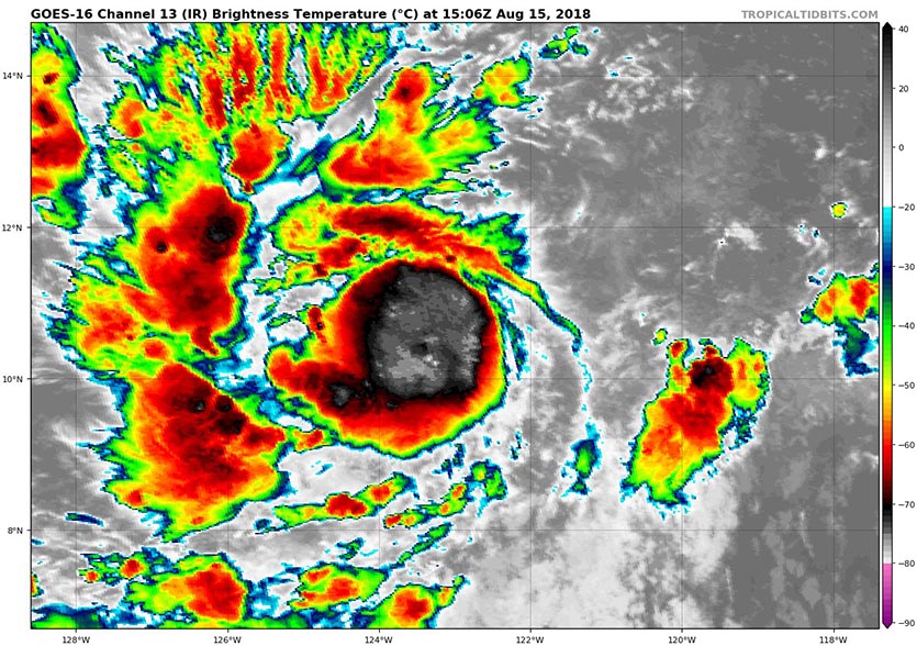
| Figure 2. Infrared satellite image of Tropical Storm Lane, taken at 11:06 am EDT Wednesday, August 15, 2018. Image credit: Levi Cowan, tropicaltidbits.com. |
Tropical Storm Lane en route to become a powerful hurricane
Newly christened Tropical Storm Lane is gathering strength far off the west coast of Mexico. Lane is the 12th storm of the very active East Pacific hurricane season of 2018. During the period 1971-2009, it took until September 19, on average, to get the 12th storm in the East Pacific. As of 11 am EDT Wednesday, Lane was located about 1200 miles southwest of Cabo San Lucas, Mexico, with top sustained winds of 40 mph. For a brand-new tropical storm, Lane is quite well structured, with rainbands already beginning to form around a small, embryonic core of showers and thunderstorms (convection).
Lane poses no immediate threat to land as it arcs toward the west and eventually west-northwest. It could become a formidable hurricane, though, as it moves over adequately warm SSTs of around 27-28°C (81–82°F). Wind shear should remain on the light side (around 10 knots or less), giving Lane plenty of opportunity to grow. Rapid intensification is a distinct possibility. The SHIPS Rapid Intensification Index at 12Z Wednesday gave Lane a 22% chance of gaining 55 knots (65 mph) of strength within 48 hours, and a new NHC tool called DTOPS suggests even greater odds. NHC projects that Lane will be a hurricane by Thursday and a Category 3 storm by Friday. “Lane seems destined to eventually become a category-4 hurricane like Hector,” said forecaster Eric Blake in NHC’s 11 am EDT Tuesday forecast discussion.
The projected angling of Lane toward the northwest, into a break in the subtropical upper-level ridging, will need to be watched closely, because it would increase the odds that Lane could affect Hawaii about a week from now.
Long-lived Hector finally dies
In the Northwest Pacific, long-lived Hurricane Hector, which crossed the International Date Line into the Western Pacific on August 13, finally expired in the cold waters well east of Japan at 0Z August 15. Hector lasted as a named storm for fifteen days. According to real-time hurricane stats at CSU, Hector had amassed a remarkable 50.3 units of Accumulated Cyclone Energy (ACE)--a little over half of the amount of ACE that a typical Atlantic hurricane season generates! Hector was a major hurricane for 7.75 consecutive days--the most consecutive days as a major hurricane for any storm in the Northeast Pacific (to 180°) on record. The old record was Norbert (1984) at 7 consecutive days as a major hurricane.
Bob Henson wrote the Tropical Storm Lane portion of this post.


