| Above:Visible-wavelength satellite image of Tropical Storm Florence at 1420Z (10:20 am EDT) Saturday, September 8, 2018. Image credit: tropicaltidbits.com. |
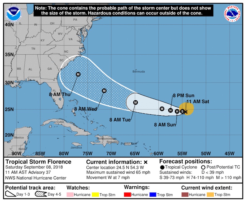
The outer edge of the 5-day uncertainty cone for Tropical Storm Florence is now over North Carolina and South Carolina, as the dangerous storm heads toward the Southeast U.S. coast. Though just a tropical storm with 65 mph winds as of 11 am Saturday, Florence is beginning to re-organize over warm ocean waters, and is expected to re-intensify into a dangerous Category 4 hurricane by Tuesday. Florence is likely to be very close to the Southeast U.S. East Coast by Thursday, bringing dangerous impacts.  |
| Figure 1. The 11 am EDT Saturday morning forecast from the National Hurricane Center places the coast of South Carolina and southern North Carolina within the "cone of uncertainty" for Florence for the five-day period ending on Thursday morning, September 13, 2018. The cone is based on track forecast errors in the Atlantic over the preceding five years (in this case, 2013–2017).The cone is designed such that a hurricane can be expected to stay within the cone about two-thirds of the time, based on past experience. The five-day diameter of the Atlantic cone is 456 miles, reflecting the average five-day error of 228 miles. Image credit: NOAA/NWS/NHC. |
Florence was about 835 miles southeast of Bermuda late Saturday morning, moving just south of due west at 7 mph. Sea surface temperatures (SSTs) were a warm 28.5°C (83°F), but Florence was embedded in an atmosphere with somewhat dry air (a mid-level relative humidity of 50%). The high wind shear of 20 – 25 knots that had been driving this dry air into the core of the storm had abated significantly on Saturday morning, and was a moderate 10 – 15 knots. Satellite images on Saturday morning showed that the storm was significantly more organized, having assumed a more symmetrical shape with impressive spiral banding. A NOAA hurricane hunter aircraft flying out of Bermuda on Saturday morning is investigating Florence, and the NOAA jet will fly a dropsonde mission on Saturday night.
Intensity forecast for Florence
Florence’s environment has grown much more conducive for intensification. Wind shear dropped to a moderate 10 – 15 knots Saturday morning, and the SHIPS model predicts shear will drop even further tonight, staying a low 5 – 10 knots through Wednesday. SSTs will gradually increase to 29°C (84°F) during this period, and ocean heat content will more than double, from 20 to nearly 50 kilojoules per square centimeter. Our top intensity models unanimously predict strengthening of Florence into a Category 3 or 4 hurricane by Tuesday, and the storm is also expected to increase in size. Florence will still be embedded in a relatively dry atmosphere, so it is possible the storm could suffer from dry air intrusions that would interfere with the intensification process, though.
The Hurricane Center is explicitly forecasting rapid intensification with #Florence, perhaps starting as soon as later today. Noted a better defined low-level ring in microwave satellite imagery. pic.twitter.com/MEJU8PgXs5
— Alex Lamers (@AlexJLamers) September 8, 2018
 |
| Figure 2. Florence (far lower right of image) will be encountering oceanic heat content (OHC) greater than 50 kilojoules per square centimeter for much of its trek toward the U.S. East Coast. Florence may end up moving across one or more warm eddies with OHC values near 75 kilojoules per square centimeter. OHC levels this high are often associated with rapid intensification of hurricanes. Image credit: UW/SSEC/CIMSS. |
Big waves coming
Florence’s power and expanding size are generating swells that were affecting Bermuda on Saturday, with waves of 5 – 8 feet in the outside waters. There are no watches for Bermuda at this time, and the island is well north of Florence’s cone of uncertainty.
Large swells will begin reaching the U.S. East Coast by Sunday, and also propagate to north and northeastward-facing coasts of the Lesser Antilles, Puerto Rico, Hispañola, the Turks and Caicos and the Bahamas into this weekend. These swells will produce life-threatening surf and rip current conditions at beaches.
Invest 94L: will it impact Florence?
An elongated area of low pressure developed in the waters a few hundred miles west of Bermuda on Friday, and was designated 94L by NHC (see Figure 2 above). If 94L shows some significant organization this weekend, upper-level outflow from the system could create wind shear that would weaken Florence, and 94L could pull Florence more to the north. However, none of the models are predicting this will happen, and Saturday morning satellite imagery showed 94L was poorly organized, with a fairly small area of heavy thunderstorms (as seen on Bermuda radar). In their 8 am EDT Saturday Tropical Weather Outlook, NHC gave 94L 2-day and 5-day odds of development of 10%.
Something to watch with 94L, though--I saw a presentation a few years ago that showed that Hurricane Katrina of 2005 increased markedly in size after it absorbed a small area of disturbed weather over the southeast Gulf of Mexico and acquired more moisture and spin. If Florence manages to absorb 94L, the increased spin the combined system will have may act to expand Florence's size considerably, leading to a larger storm surge and an increased area of wind and rainfall impacts. Satellite images on Saturday morning showed some of 94L’s moisture heading towards the northwest flank of Florence, but it is unclear at this point if Florence will pass close enough to 94L to get a significant boost in moisture and spin.
 |
| Figure 3. The 0Z Saturday, September 8, 2018 track forecast by the operational European model for Florence (red line, adjusted by CFAN using a proprietary technique that accounts for storm movement since the time of the model run), along with the track of the average of the 50 members of the European model ensemble (heavy black line), and the track forecasts from the “high probability cluster” (grey lines)—the four European model ensemble members that have performed best with Florence thus far. The forecasts show a wide range of possible landfall locations, but all of them resulting in a U.S. East Coast landfall. Image credit: CFAN. |
Track forecast for Florence: significant danger for the U.S. East Coast
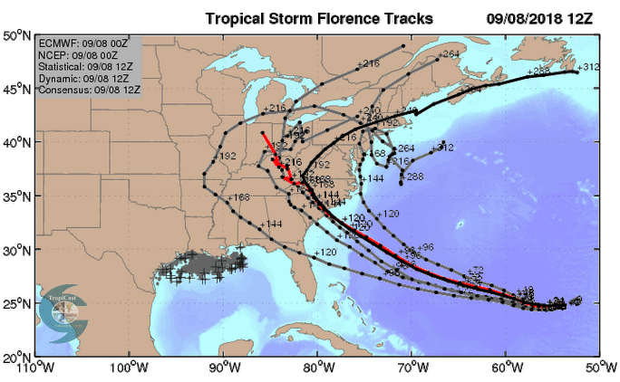
The forecast of Florence and impact to the U.S. East Coast mid- to late next week remains very uncertain, but the danger to the coast has increased with each set of model runs over the past three days.
Florence is being steered by the clockwise flow around the Bermuda High, the semi-permanent high-pressure system centered over the North Atlantic Ocean. The edge of the Bermuda High will lie along the U.S. East Coast during the middle of next week, and when Florence rounds the southwestern flank of the Bermuda High, the hurricane will turn to the northwest and then north. Thus, the exact position and orientation of the southwestern flank of the Bermuda High, in combination with the strength of the trough of low pressure that will be just to its west, will be the keys to the timing and location of Florence’s turn to the north. Since this turn is still five days away, there is substantial model disagreement on this, as the average error in a 5-day official NHC forecast in recent years has been just over 200 miles (see Figure 1). A direct hit from Florence could happen anywhere along the swath of coast from northern Florida to Massachusetts, with North Carolina and South Carolina being at greatest risk. The main scenarios as I see them, with some rough odds as to their likelihood:
1) Florence will continue heading west-northwest to northwest until landfall in North Carolina or South Carolina on Thursday (40% chance). Recent operational runs of the European model have championed this scenario, along with some recent operational runs of the GFS model.
2) The Bermuda High intensifies as Florence approaches the coast, resulting in a more westerly or even west-southwesterly motion, with a landfall in Georgia or northern Florida on Thursday (10% chance). Recent runs of the UKMET model have suggested this outcome.
3) Florence will turn to the north just off the coast of North Carolina, making landfall in the mid-Atlantic or New England between Virginia and Massachusetts on Saturday (20% chance). Several recent operational runs of the GFS model and many members of the GFS and European model ensemble forecasts have made this forecast.
4) Florence will turn to the north just off the coast of North Carolina, then head northeast out to sea, without making any landfall (30% chance). Members of the GFS and European model ensemble forecasts have made this forecast. A landfall in Canada isn't completely out of the question, even if Florence misses the United States.
All of these scenarios also carry the risk that Florence will stall just inland or just off the coast, and potentially perform a clockwise loop, delivering a multi-day punishment of the coast. There have been a number of model runs over the past day suggesting that steering currents may collapse on Saturday, stranding Florence. Such an outcome would raise the risk of torrential rains across parts of the mid-Atlantic, where the remnants of Gordon will be dumping significant rain this weekend atop already-saturated ground. (NOAA has issued a high risk of excessive rainfall for Saturday as Gordon's remnants move across southern Illinois and Indiana.)
If you live in a hurricane-prone location, now is a good time to make sure you have a preparedness plan in place!
Our next update today will be on the other tropical cyclones in the Atlantic and Pacific we are concerned about. This is the craziest peak week of hurricane season I’ve ever experienced!
Bob Henson contributed to this post.


