| Above: Tropical Storm Chris at 1 pm EDT July 8, 2018. At the time, Chris had top winds of 45 mph. Image credit: NOAA/RAMMB. |
Tropical Storm Chris was christened in the waters a few hundred miles off of the North Carolina coast early Sunday morning, becoming the third named storm of the 2018 Atlantic hurricane season. Chris’s formation date of July 8 comes more than a month earlier than the typical August 13 date for the appearance of the season’s third named storm. The first hurricane of the season typically forms on August 10, and the appearance of 2018’s first hurricane on July 6--Beryl--also came more than a month earlier than usual.
A NOAA hurricane hunter aircraft on Sunday morning measured surface winds of 45 mph in Chris, and found that the storm had become more organized, with the most intense heavy thunderstorms located near the center of circulation. Chris was over the warm Gulf Stream Current, where sea surface temperatures (SSTs) were near 28.5°C (83°F), about 1°C (1.8°F) above average. Wind shear was a moderate 10 - 15 knots—favorable for development. There was dry air to the north of the center, associated with a cold front stalled over North Carolina, and this dry air has been slowing development.
 |
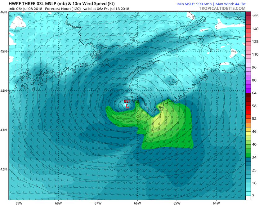
| Figure 1. Predicted winds for Chris at 2 am EDT Friday, July 13, 2018, from the 6Z Sunday, July 8, 2018, run of the HWRF model. Chris was predicted to be making landfall in Nova Scotia, Canada, with top winds near 44 kt (51 mph, yellow colors). The HWRF was our best intensity model in 2017. Image credit: Levi Cowan, tropicaltidbits.com. |
Forecast for Chris
Steering currents for Chris will be very weak through Tuesday, and the storm will meander over the warm waters of the Gulf Stream, a few hundred miles off the North Carolina coast. Ordinarily, a stalled storm will churn up colder waters from below, cooling the surface and causing weakening. However, the flow of warm waters from the south along the Gulf Stream will maintain a continuous source of warm water for Chris, allowing for strengthening despite its stalled condition. A trough of low pressure will pass to the north of Chris on Tuesday through Wednesday, and this trough is expected by all the models to be strong enough to turn the storm to the northeast on Tuesday night, towards the Canadian maritime provinces, according to their 0Z and 12Z Sunday runs.
Chris’ strong winds are already kicking up high surf along the North Carolina coast, where a High Surf Advisory is in effect. Waves of 5 – 8 feet are likely to the north of Cape Hatteras, and 4 – 6 feet to the south. The wind and waves will combine to cause a high rip current danger through Tuesday. Weather radar showed that Chris’ rains were just beginning to affect the North Carolina Outer Banks early Sunday afternoon, and rains of 1 – 2” can be expected there Sunday night through Tuesday as Chris lingers and expands in size.
Wind shear is predicted by the SHIPS model to remain moderate through Wednesday, which should allow Chris to intensify into a Category 1 or 2 hurricane. Our top intensity models—the HWRF, DSHIPS, and LGEM—predicted on Sunday morning that Chris would reach peak intensity on Wednesday evening or early Thursday morning with maximum sustained winds in the Category 1 – 2 range, between 85 – 105 mph. When Chris moves past the latitude of New Jersey, the storm will leave the warm waters of the Gulf Stream, and also encounter high wind shear of 20+ knots. This is expected to occur Wednesday afternoon or evening, and Chris should steadily weaken as it speeds over increasingly colder waters towards Nova Scotia and Newfoundland, Canada. Landfall in Canada will likely occur Thursday night or Friday morning, posing both a high wind and heavy rainfall threat, but it is possible that Chris will miss making a direct hit on Canada, passing just south of Newfoundland, and predicted by the 0Z Sunday run of the European model.
Weakened Tropical Storm Beryl approaching Lesser Antilles Islands
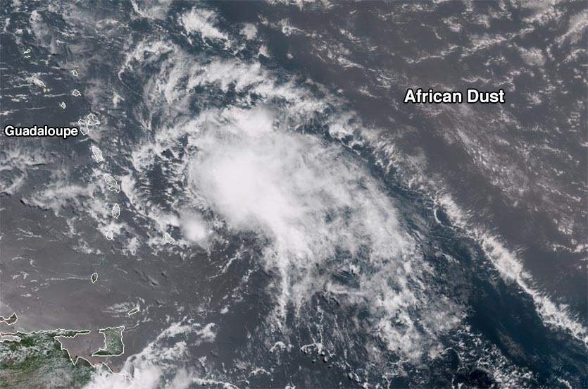
Heavy rain showers from Tropical Storm Beryl were spreading into the Leeward Islands on Sunday afternoon, as seen on Martinique radar, as the storm sped west-northwestward at 23 mph. Beryl continued to struggle against increased wind shear and dry air on Sunday afternoon, with satellite images showing the storm was having trouble generating heavy thunderstorms and maintaining a coherent surface circulation. An Air Force hurricane hunter mission on Sunday morning was unable to find a closed surface circulation in Beryl, and strong mid- to upper-level winds out of the west have been causing high wind shear of 20 knots and driving dry air into Beryl’s circulation, disrupting the storm. However, the Hurricane Hunters did measure surface winds near 50 mph. Another hurricane hunter mission is scheduled for Sunday evening.
 |
| Figure 2. GOES-16 image of Beryl at 11:45 am EDT Sunday July 8, 2018. Image credit: NOAA/RAMMB. |
Forecast for Beryl
The strengthening ridge of high pressure steering Beryl will bring Beryl into the Lesser Antilles Islands on Sunday night through Monday morning, with Guadaloupe and Dominica at the highest risk of receiving a direct hit. The north side of Beryl will have much stronger winds than the south side, due to the rapid forward motion of the storm. Due to Beryl’s small size, though, only one island is likely to receive significant winds, and the storm could slip between a gap in the islands without bringing its strongest winds to any of the islands.
The 8 am EDT Sunday SHIPS model run predicted that wind shear would continue to rise and the atmosphere would continue to grow drier through Monday, and these combined influences should act to reduce Beryl to a tropical wave by the time it arrives in the eastern Caribbean on Monday morning, though the storm could lose tropical storm status before reaching the Lesser Antilles on Sunday night.
Heavy rains are likely to be the main concern from Beryl in the Lesser Antilles, since even a disorganized tropical storm can bring dangerous rains to the islands. The remnants of Beryl also have the potential to bring heavy rains to Puerto Rico and Hispaniola on Monday and Tuesday, and the remnants could potentially regenerate into a tropical depression in the waters between Bermuda and the U.S. East Coast late in the week, as explained in the 11 am Sunday NHC Discussion.
Super Typhoon #Maria, a ghastly appearance on satellite. This typhoon is expected to remain a significant storm and landfall over eastern Asia. Not a good scenario. pic.twitter.com/DJ8vb6b5Vr
— Michael Ventrice (@MJVentrice) July 8, 2018
Category 5 Super Typhoon Maria heads towards China
Super Typhoon Maria was back at Category 5 strength with 160 mph winds late Sunday morning, as it steamed northwest at 16 mph towards China. Maria was also at Category 5 strength on Thursday, until an eyewall replacement cycle knocked its top winds down to 145 – 155 mph Friday through Saturday. Maria is Earth’s second Category 5 storm of 2018, joining Tropical Cyclone Marcus, which peaked with 160 mph winds on March 21, 2018, in the waters northwest of Australia.
SSTs of 29 - 30 °C (84 - 86°F) and moderate wind shear of 10 - 15 knots should allow Maria to remain a super typhoon with 150+ mph winds until Monday afternoon, when the typhoon will enter a region of less favorable upper-level outflow, lower oceanic heat content, and increased wind shear, likely causing slow weakening.
The models are in excellent agreement that Maria’s northwest track over the next three days will bring it through Japan’s Miyako Islands (south of Okinawa) on Monday night and Tuesday morning (U.S. time), with the official JTWC forecast calling for the typhoon to be a Category 4 storm with 130 - 135 mph winds then. Maria is a huge storm, with hurricane-force winds that extend out up to 75 miles from the center, and tropical storm-force winds that extend out up to 225 miles from the center. So, even though the typhoon is expected to pass nearly 200 miles south of Okinawa on Monday night, that island will likely receive tropical storm-force winds of 40 – 45 mph. Fortunately, Maria’s rains will remain well south of southwestern Japan, where torrential rains have triggered floods that have killed 70 and left 90 missing over the past week (see weather.com’s latest write-up on this disaster).
Late Monday (U.S. EDT), Maria is likely to pass very close to Miyakojima Island (population 56,000) in Japan’s Miyako Islands (see Miyakojima radar here). Maria is expected to be a borderline Category 3 or 4 storm in the Miyako Islands, and a Category 3 storm on Tuesday night when it passes very close to the northern end of Taiwan. Maria is expected to make landfall early Wednesday morning in China as a weakening Category 3 typhoon. All of these locations have the potential to receive devastating impacts from Maria.


