| Above: Tropical Storm Chantal, located southeast of Newfoundland, Canada, as seen at 9:40 am EDT August 21, 2019. Image credit: NOAA/RAMMB. |
An area of low pressure that festered along the U.S. East Coast early this week formed into Tropical Storm Chantal at 11 pm EDT August 20. Chantal, a minimal tropical storm with 40 mph winds as of 11 am EDT Wednesday, was headed east at near 20 mph over the waters southeast of Newfoundland, Canada. Chantal is expected to be a “fish storm” that will not threaten any land areas—just bother fish in the ocean.
Tropical Storm #Chantal has formed at a latitude of 40.2ºN. Pending on post-season reanalysis, this would make Chantal the 6th tropical cyclone in modern record (1950-2019) to first reach TS strength N of 40ºN, most recent being an unnamed storm in '06. Record is 42.0º in '52. pic.twitter.com/VrpIhEjLyK
— Tomer Burg (@burgwx) August 21, 2019
Chantal destined to be not long for this world
Chantal was experiencing very marginal conditions for sustaining a tropical storm on Wednesday morning, with high wind shear of 20 knots, ocean temperatures (SSTs) near 26°C (79°F), and a dry atmosphere with a mid-level relative humidity of 35 - 40%. Satellite images showed that although Chantal had a vigorous circulation, heavy thunderstorm activity was limited to a small area on the storm’s east side, due to dry air and high wind shear.
According to the 12Z Wednesday run of the SHIPS model, challenging conditions will continue for Chantal over the next two days, with SSTs expected to range from 25 - 26°C in a dry atmosphere with wind shear a moderate 10 – 20 knots. These conditions are likely to weaken Chantal to a tropical depression by Friday, then destroy the storm this weekend.
 |
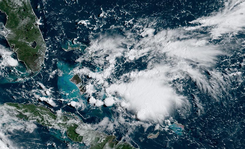
| Figure 1. The next system to watch: an area of disturbed weather over The Bahamas that was producing a moderate-sized area of disorganized heavy thunderstorm activity at 10 am EDT Wednesday, August 21, 2019. Image credit: NOAA/RAMMB. |
More active times coming for the Atlantic?
Chantal’s formation date of August 20 comes a week later than the typical August 13 date for the season’s third storm. The quiet period in the Atlantic that came after the demise of Hurricane Barry until now, from July 15 to August 19, was the first time that the Atlantic had no named storm activity in that stretch since 1982, according to CSU hurricane expert Dr. Phil Klotzbach.
Historically, about 2/3 of all Atlantic hurricane activity occurs between August 20 - October 10, so we are due for an uptick in activity in the next few weeks. The next system to watch is an area of low pressure over The Bahamas that was producing a moderate-sized area of disorganized heavy thunderstorm activity on Wednesday morning.
The Wednesday morning runs of our top models for predicting tropical cyclone genesis, the European, GFS, and UKMET models, all predicted the possibility of the season’s next tropical storm coming early next week from this system, as it takes a track roughly parallel to the Southeast U.S. coast. Steering currents suggest a motion to the north-northeast by the middle of next week, which would potentially put North Carolina at risk of a heavy rain event. In their 8 am EDT Wednesday Tropical Weather Outlook, NHC gave this system 2-day and 5-day odds of development of 0% and 20%, respectively. The next name on the Atlantic list of storms is Dorian.
Day 7. About halfway across the Atlantic Ocean. Very pleasant conditions. pic.twitter.com/1uRo2eomOg
— Greta Thunberg (@GretaThunberg) August 20, 2019
Chantal’s impact on Greta Thunberg’s journey across the Atlantic
Student climate activist Greta Thunberg is dodging Chantal on her way from Europe to attend the first-ever United Nations Youth Climate Summit, scheduled for next month in New York. In order to avoid flying and the associated carbon emissions, Thunberg is on a two-week journey across the North Atlantic aboard a zero-emissions racing yacht, the Malizia II. The boat, which has no toilet, is fitted with solar panels and also gathers energy from underwater turbines.
The website windy.com has a tracking site showing the course of the Malizia II thus far. At around 10 am EDT Wednesday, the ship was in the central North Atlantic near 42°N, 38°W, near a weak low pressure system northeast of Chantal. The yacht's track has angled northwest over the past day or so, perhaps taking Chantal’s future into account. With this northwestward jog, Greta and the Malizia II should have little trouble staying well clear of Chantal, although some swells could reach the boat. In 2016, the yacht was damaged after encountering 46-mph winds and 26-foot waves on a round-the-world race called the Vendée Globe.
According to windy.com, the team has covered about 500 miles in the past 24 hours and was still about 1800 miles east of New York City as the crow flies.
 |
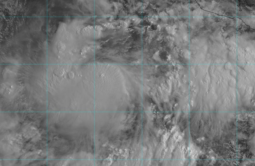
| Figure 2. Visible-wavelength satellite image of Tropical Depression 10-E (left side of image) at 1445Z (10:45 am EDT) Wednesday, August 21, 2019. Image credit: tropicaltidbits.com. |
TD 10-E in Northeast Pacific expected to become Tropical Storm Ivo
Within a large swath of moisture simmering in the Northeast Pacific, a low-level circulation appears to have closed off south of Mazatlan, Mexico. Based on this, NHC started advisories on Tropical Depression 10-E at 11 am EDT Wednesday. TD 10-E was centered about 550 miles south-southeast of Cabo San Lucas, moving west-northwest at 18 mph with top sustained winds of 35 mph. Forecast models agree that TD 10-E’s track over the next several days will keep it far enough off the Mexican coast to avoid major impacts. Showers and thunderstorms with heavy rain could move onshore along the fringes of TD 10-E’s wide moisture swath.
Moderate wind shear (10 – 20 knots) and warm SSTs (29-30°C or 84-86°F) should allow TD 10-E to gradually intensify, perhaps reaching hurricane strength as soon as Thursday night. Much cooler waters off the Baja Peninsula should lead to the system’s rapid demise this weekend or early next week.
No other development is expected in the immediate future in the Northeast Pacific, as convection has withered around former Invest 97E well to the west of TD 10-E.
Bob Henson co-wrote this post.


