| Above: Super Typhoon Hagibis at 11 am EDT October 7, 2019. At the time, Hagibis was a Category 5 storm with 160 mph winds passing through the Northern Mariana Islands. Image credit: NOAA/RAMMB. |
Super Typhoon Hagibis put on one of the most phenomenal displays of rapid intensification in tropical cyclone history overnight, intensifying from a tropical storm with 60 mph winds to a Category 5 super typhoon with 160 mph winds in the 24 hours ending at 8 am EDT Monday. A 100 mph increase in maximum sustained winds in just 24 hours like Hagibis just saw is a very rare rate of rapid intensification. NOAA's Hurricane Research Division lists only one Northwest Pacific typhoon that did so: Super Typhoon Forrest of 1983.
In the Western Hemisphere, where we have the Hurricane Hunters to more accurately quantify rapid intensification, the record holders are Hurricane Patricia of 2015 (off the Pacific coast of Mexico), which intensified by 120 mph in 24 hours, and the Atlantic’s Hurricane Wilma of 2005 (off of Mexico’s Yucatan Peninsula), which intensified by 110 mph in 24 hours. Since we are relying only on relatively imprecise satellite estimates of Hagibis’ intensity, it is possible that a hurricane hunter aircraft might have found an even greater rate of intensification.
Here's an updated image loop of #Typhoon #Hagibis from #Himawari8 via Band 13 IR rapid scan, which monitors a storm's vertical moisture profile & detects areas of strong convective activity. Darker areas signify taller clouds, which correlate with more intense areas of the storm. pic.twitter.com/6gRIDMbUIw
— NOAA Satellites (@NOAASatellites) October 7, 2019
Hagibis passed 75 miles north of the Saipan airport in U.S. Northern Mariana Islands at 12:18 am local time Tuesday (10:18 am EDT Monday), and it is likely that tropical storm-force winds were experienced there (though the airport wind sensor failed 5 hours before Hagibis’ closest approach). No inhabited areas will experience the full fury of the eyewall winds, as the typhoon’s eyewall is passing near two uninhabited islands: Anatahan and Sarigan. According to the Japan Meteorological Agency, Hagibis bottomed out with a central pressure of 915 mb at 11 am EDT Monday.
 |
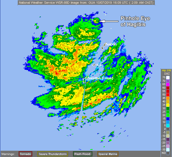
| Figure 1. Radar image of Hagibis from the Guam radar at 12:09 pm EDT Monday, October 7, 2019. A tiny “pinhole” eye with a diameter of 6 miles was apparent. |
A typhoon warning is in effect for Saipan, Tinian, Alamagan and Pagan islands in the Northern Mariana Islands, and a tropical storm warning is in effect for Guam, Rota and Agrihan islands. Radar from Guam showed heavy rains from Hagibis affecting the entire Northern Mariana Islands chain. Satellite images of Hagibis showed a large and impressive typhoon with a tiny "pinhole" eye characteristic of ultra-intense tropical cyclones.
Well this is something else. It is dubious to measure #Hagibis's eye size with radar bins this wide, but it's darn small. This is at a beam height of ~29,000 feet, which means the eye is likely a touch smaller at its base, since eyewalls slope outward with height. pic.twitter.com/WBBtrvuoLp
— Levi Cowan (@TropicalTidbits) October 7, 2019
Hagibis is Earth’s fourth Cat 5 of 2019
Hagibis is the planet’s fourth Category 5 storm of 2019. The other three were Dorian and Lorenzo in the Atlantic, and Super Typhoon Wutip in the Northwest Pacific. Lorenzo and Wutip both peaked with 160 mph winds, while Dorian peaked with 185 mph winds at landfall in The Bahamas. Earth averaged 5.3 Category 5 storms per year between 1990 and 2018, according to ratings made by NOAA's National Hurricane Center and the U.S. Navy's Joint Typhoon Warning Center. Last year (2018) saw the second highest number of Cat 5s on record—eleven.
Hagibis is the 19th named storm of the year in the Northwest Pacific, according to the Japan Meteorological Agency. The Joint Typhoon Warning Center lists 17 named storms and 8 typhoons so far this year. From 1981-2010, an average of 26 Northwest Pacific named storms formed each year, 17 of which became typhoons. The Atlantic basin averages 12 named storms and 6 hurricanes per year.
Hagibis means "rapidity", "velocity", or "speed" in the Tagalog language spoken in the Philippines, and is also the name of one of the first comic book heroes in the history of komiks (comics) in the country.
Why is there such heightened interest in #Japan w/ STY #Hagibis? The country has incurred three of its costliest tropical cyclone events on record in just the past 14 months: #Jebi #Trami #Faxai pic.twitter.com/fu8HpCV2fV
— Steve Bowen (@SteveBowenWx) October 7, 2019
Hagibis a threat to Japan
For the next 2-3 days, Hagibis should remain a formidable typhoon. Wind shear affecting Hagibis will remain low to moderate (around 10 knots). Sea surface temperatures will cool only slightly, dropping to around 29°C (84°F), and the environment will get somewhat drier (mid-level relative humidity dropping from around 70% to around 60%). There will likely be fluctuations in Hagibis’s strength based mainly on the timing of one or more eyewall replacement cycles. Any of these could bring down the top sustained winds for a day or more, while enlarging Hagibis by spreading the wind energy over a broader area.
Through this week, Hagibis will carve out a classic recurvature path, arcing toward the northwest and then north toward Japan and perhaps making landfall this weekend on the island of Honshu. Small variations in the timing and angle of the recurvature will determine what parts of Honshu might be affected. It’s a safe bet that Hagibis will be significantly weakening as it approaches Japan, thanks to increasing wind shear, drier air, and cooler SSTs, but the pace of that weakening remains to be seen. In its Monday morning forecast, JTWC predicted that Hagibis would be nearing the central coast of Honshu east of Kyoto on Saturday as a Category 2 storm.
Two systems in the Atlantic to watch
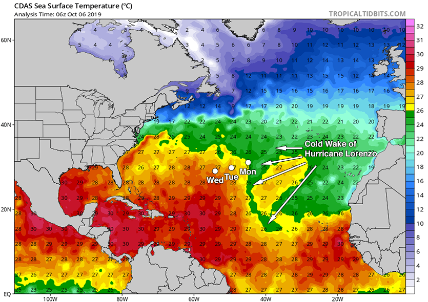
A non-tropical low-pressure system was developing on Monday morning along a cold front over the central North Atlantic, between Bermuda and the Azores Islands. The low will initially be over cool waters stirred up last week by the passage of Hurricane Lorenzo, with sea surface temperatures (SSTs) near 26°C (79°F). The clockwise flow of air around a ridge of high pressure to the north of the low will force it to move westward at about 10 mph during the week, which will put it into a region with warmer SSTs near 27°C (81°F) by Wednesday. These warmer SSTs may allow development into a tropical or subtropical storm by Wednesday. There will be plenty of dry air to the northwest of the low that may interfere with development, and upper level-outflow from a disturbance to the west (see discussion below) is likely to bring high wind shear on Wednesday, discouraging further development. In their 2 pm EDT Monday Tropical Weather Outlook, NHC gave the low 2-day and 5-day odds of development into at least a tropical or subtropical depression of 50% and 50%, respectively.
 |
| Figure 2. Sea surface temperatures and predicted positions on Monday, Tuesday and Wednesday of a low-pressure system that was being given 2-day and 5-day odds of development of 40% and 50%, respectively, by NHC on Monday morning. Image credit: tropicalbits.com. |
Another non-tropical low-pressure system will develop on Tuesday a few hundred miles east of the North Carolina coast, then meander several hundred miles off the U.S. coast during the week. The low will initially be over the warm waters of the Gulf Stream, with sea surface temperatures (SSTs) near 27°C (81°F); this may allow the low to progress towards becoming a tropical cyclone. However, if the low progresses far enough to the north, to the waters off the coast of Maryland, it will cross over the boundary of the Gulf Stream into cooler waters with SSTs near 25°C (77°F). This will make development into a subtropical cyclone, rather than a tropical cyclone, more likely to occur. There will be plenty of dry air and wind shear for the low to contend with. Regardless of tropical or subtropical development, the low has the potential to bring strong easterly winds to portions of the New England and Mid-Atlantic coasts beginning on Wednesday, which could cause coastal flooding concerns. In their 2 pm EDT Monday Tropical Weather Outlook, NHC gave the low 2-day and 5-day odds of development of 0% and 30%, respectively.
The next two names on the Atlantic list of storms are Melissa and Nestor.
Bob Henson contributed to this post.


