| Above: The eye of Super Typhoon Hagibis as seen at 1Z October 10, 2019 by the Sentinel-3 satellite. At the time, Hagibis was a Category 5 super typhoon with 160 mph winds. Image credit: Antonio Vecoli, Copernicus EU. |
Super Typhoon Hagibis has begun its anticipated weakening trend, but it was still a formidable Category 4 storm with 150 mph winds at 11 am EDT Thursday, about 48 hours before its expected landfall in Japan.
Strong typhoons do not typically threaten central Japan as late as mid-October, but forecast models are in close agreement on a classic recurving path that will bring the typhoon close to the Tokyo Bay region of Japan's Honshu Island, with landfall occurring near 12Z (8 am EDT Saturday). Though Hagibis is expected to make landfall, only a slight shift to the right could result in the typhoon’s eye passing just offshore, sparing Japan the worst storm surge and wind impacts.
Satellite images on Thursday afternoon showed a steady reduction in the intensity and areal coverage of Hagibis’ heavy thunderstorm activity, though the typhoon still featured a prominent 23-mile diameter eye. Dry air was beginning to wrap into the circulation, resulting in a fragmentation of Hagibis’ formerly complete eyewall. Outer bands from the big typhoon were already spreading rain showers to the Tokyo area, as seen on Japanese radar.
 |
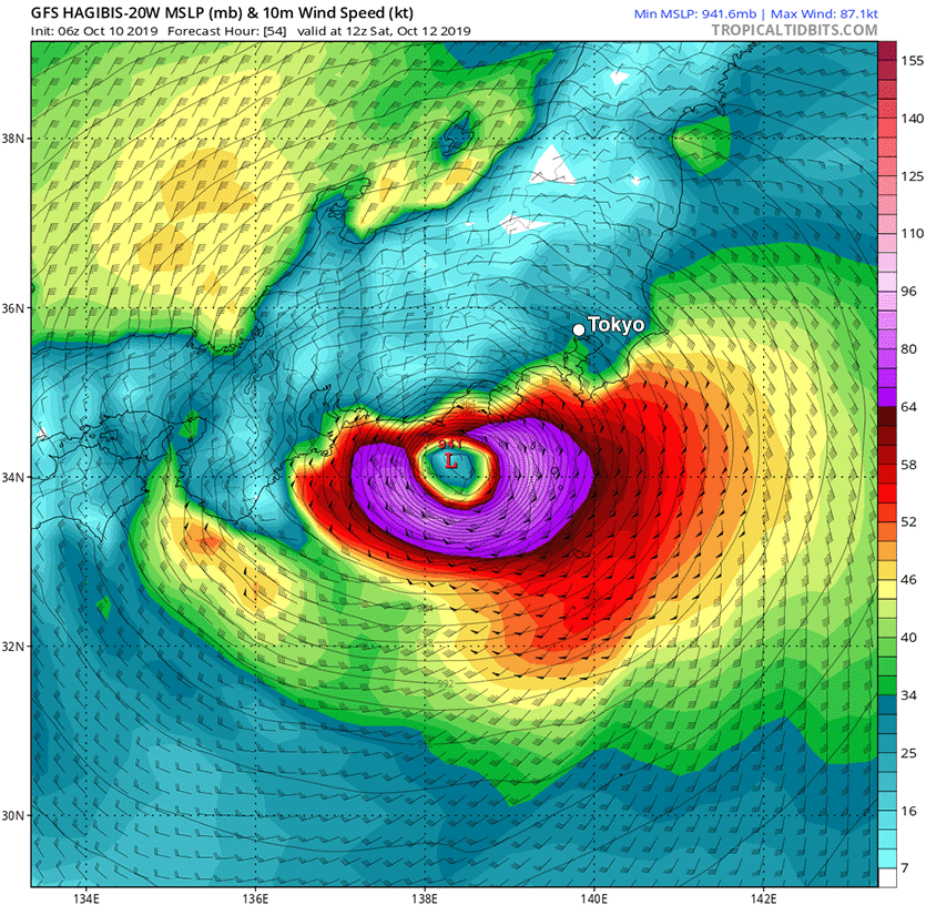
| Figure 1. Predicted surface winds (colors) and sea level pressure (black lines) at 12Z (8 am EDT) Saturday, October 12, 2019, from the 6Z Thursday run of the GFS model. The model predicted that Hagibis would make landfall southwest of Tokyo as a Category 2 typhoon with 100 mph winds, with the center passing over Tokyo near 16Z (noon EDT) Saturday. Image credit: tropicaltidbits.com. |
Hagibis was a large typhoon at 11 am EDT Thursday, with hurricane-force winds that extended out 80 - 90 miles on its north side—the side that will be impacting Japan on Saturday. As cooler waters, dry air, increased wind shear, and land interaction weaken the typhoon over the next two days, Hagibis’ hurricane-force wind field is predicted to shrink, and extend 40 – 50 miles to its north at the time of landfall on Saturday. However, the typhoon’s area of tropical storm-force winds is predicted to expand from the current 300-mile radius to about 350 miles at landfall. This large wind field will drive a large and damaging storm surge to the coast, if the eye of Hagibis makes landfall. Extensive wind damage and flash flooding and mudslides due to heavy rain will also be major threats from Hagibis.
So we're clear, the #Hagibis landfall risk in #Japan is not unprecedented. This region near Tokyo saw a Category 2 landfall (#Faxai) literally four weeks ago w/ a multi-billion-dollar insurance payout. The uniqueness of Hagibis remains its exceptional rate of intensification. pic.twitter.com/62CDpzTL1s
— Steve Bowen (@SteveBowenWx) October 10, 2019
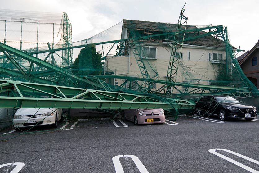
The Joint Typhoon Warning Center predicted at 11 am EDT Thursday that Hagibis would move over or near Tokyo Bay around 10 am EDT Saturday as a Category 2 typhoon with 100 mph winds. This is roughly comparable to the strength of Typhoon Faxai, which struck Tokyo Bay as a Category 2 typhoon last month, inflicting at least $7 billion in damage, according to Aon. Faxai was Japan’s sixth most damaging typhoon on record (see below). Hagibis is disrupting the Rugby World Cup taking place this month in several sites in Japan, with two Saturday matches now cancelled.
 |
| Figure 2. Golf practice range fences collapsed onto a house and vehicles following the passage of Typhoon Faxai on September 9, 2019 in Ichihara, Japan. Credit: Tomohiro Ohsumi/Getty Images. |
Three of the top ten most damaging Japanese typhoons have occurred since 2018
According to inflation-adjusted damage estimates from Aon and EM-DAT, the international disaster database, three of the top ten most damaging Japanese typhoons since 1950 have occurred since 2018; Hagibis threatens to be another:
Mireille, 1991, $19.1 billion
Jebi, 2018, $12.6 billion
Songda, 2004, $12.5 billion
Flo, 1990, $8.0 billion
Bart, 1999, $7.8 billion
Faxai, 2019, $7.0 billion
Vera, 1959, $5.3 billion (5098 deaths)
Sarah, 1986, $5.1 billion
Vicki, 1998, $4.8 billion
Trami, 2018, $4.6 billion
This list does not include the $10.2 billion flood disaster in southern Japan in July 2018, which was caused by the presence of a stationary seasonal frontal boundary enhanced by remnant moisture from Typhoon Prapiroon.
Climate change is likely increasing Japan’s typhoon risk
Hurricane scientists agree that typhoons in the Northwest Pacific are reaching their maximum intensities at a more northerly latitude than they used to, which has increased the typhoon risk to Japan. In a 2019 review paper by 11 hurricane scientists, Tropical Cyclones and Climate Change Assessment: Part I. Detection and Attribution, nine of 11 authors concluded that the balance of evidence suggested that human-caused climate change contributed to the observed poleward migration of more intense typhoons.
In the same study, ten of 11 authors concluded that the balance of evidence suggests that there is a detectable increase in the average intensity globally of hurricane-strength tropical cyclones (including typhoons) since the early 1980s, and eight of 11 authors concluded that the balance of evidence suggests that human-caused climate change contributed to this increase in intensity.


