| Above: Typhoon Maria at 8:20 am EDT July 10, 2018 as it approached Taiwan. The eye had become elliptical and distorted, image credit: Central Weather Bureau, Taiwan. |
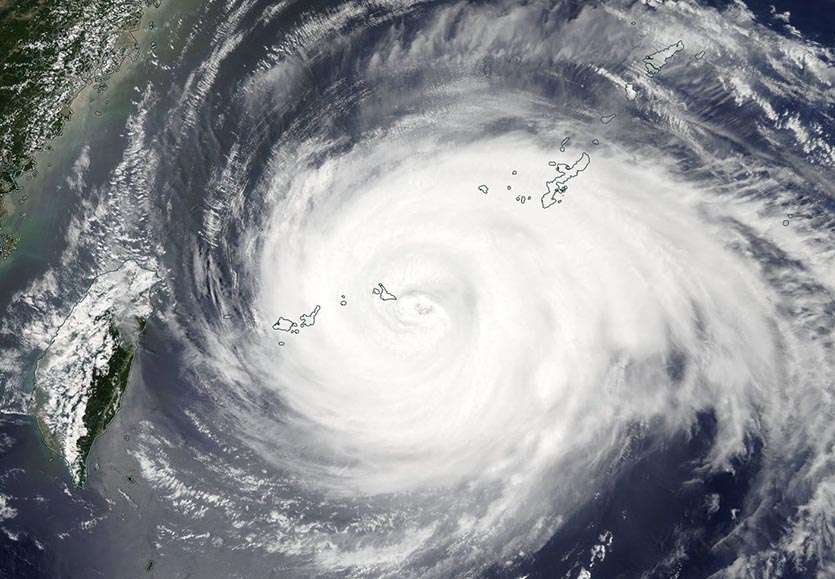
A weakening Typhoon Maria powered through Japan’s Miyako Islands early on Tuesday, delivering a direct hit to Miyakojima Island (population 56,000) as a Category 3 storm with 125 mph winds. Maria’s landfall there, at approximately 2 am EDT July 10, marked the first landfall by a major (Category 3 or stronger) tropical cyclone of the 2018 Northern Hemisphere season. Storm chaser James Reynolds rode out the typhoon in Miyakojima, and has posted a number of impressive videos of the landfall.
Himawari looked into the eye of #Typhoon #Maria today as the dangerous storm threatens #Taiwan and #China with torrential rainfall and typhoon force winds. pic.twitter.com/uQSquyFln3
— NOAA Satellites (@NOAASatellites) July 10, 2018
Miyakojima Island lies in one of the most typhoon-prone locations in the Pacific, and is well-equipped to withstand the regular batterings that these great storms bring. All three airports on the island transmitted data through the passage of the eye, with the main airport recording peak 10-minute average sustained winds of 22.4 m/s (50 mph) in the east eyewall, and a central pressure of 946 mb in the eye. As of 11 pm local time Tuesday, a 24-hour rainfall amount of 133 mm (5.24”) had fallen there. Shimojishima Airport recorded sustained winds of 28 m/s (62 mph), and Miyako Airport, 29.2 m/s (65 mph). To convert from 10-minute average winds to the 1-minute average winds used in the U.S., one needs to multiply by a factor of 1.1 or so, depending upon the location of the wind sensor. After doing this conversion, we see that Miyakojima did not measure higher than Category 1 hurricane winds, but remember that the wind measurements were only available once per hour, and the typhoon undoubtedly brought higher winds during the most intense part of the eyewall’s passage. On Tuesday morning EDT, the eye of Maria was analyzed as being 35 miles in diameter. Since Maria was moving at 17 mph, this implies that any spot near the center of the eye could have experienced relatively calm conditions for an unusually long span, perhaps an hour or more.
 |
| Figure 1. MODIS visible satellite image of Maria as its west eyewall moved over Japan’s Miyakojima Island at approximately 1 am EDT July 10, 2018. Image credit: NASA. |
Maria battering Taiwan, headed for China
Radar data from Taiwan and satellite imagery show that Maria has weakened considerably since its heyday as a Category 5 storm with 160 mph winds. Higher wind shear, cooler ocean temperatures, and a less favorable upper-level outflow pattern have all combined to knock Maria down to Category 3 strength, as of the 5 am EDT Tuesday advisory from the Joint Typhoon Warning Center (JTWC). Continued weakening is likely due to these factors, plus the interaction with land that will occur as Maria passes just to the north of Taiwan Tuesday afternoon. Late morning on Tuesday (U.S. EDT), Maria’s outer bands were battering northern Taiwan, where rainfall rates of up to 2”/hour were observed. Maria is a large storm, with hurricane-force winds that extend out up to 65 miles from the center and tropical storm-force winds that extend out up to 220 miles from the center. An impressive long-period radar animation put together by Brian McNoldy shows Maria's large size well.
Maria will make landfall in China Tuesday night (U.S. EDT), and will likely be a Category 2 storm with 100 mph winds then. Even at this reduced strength, Maria has the potential to be a billion-dollar disaster for China, with wind, flooding, and storm surge damage all a concern.
Maria brings remarkable warmth to Taiwan
Major tropical cyclones always have large-scale areas of subsidence (sinking air) along their periphery, which create unusual warmth. In the case of Maria, the counter-clockwise flow of air was also bringing strong west-to-east winds over the mountainous Taiwan, creating downslope winds along the coastal east side of the island. These winds warmed and dried as they descended the mountains, creating unusually warm and dry conditions along Taiwan’s east coast during the day Tuesday. Meteo France meteorologist (and climate data enthusiast) Etienne Kapikian pointed out to me in an email that Taiwan Central Weather Bureau's website showed a maximum temperature of 104.5°F (40.3°C) at 14:40 local time Tuesday at Tianxiang, Hualien County, which is on the eastern side of Taiwan. If verified (and there is some doubt about this figure, since the highest hourly temperature at the site today was just 99.1°F, or 37.3°C), this would be the hottest temperature ever measured in Taiwan (previous record: 40.2°C at Taitung on May 9, 2004).
We'll have a new post on Tropical Storm Chris by early afternoon (EDT).


