| Above: MODIS image of Super Typhoon Mangkhut on Saturday afternoon, September 15, 2018. The typhoon had just crossed Luzon Island in the Philippines, and was located along the island's west coast. Image credit: NASA Worldview. |
Typhoon Mangkhut barreled into the island of Luzon in the Northern Philippines early Saturday as a Category 5 hurricane with 165 mph winds, killing at least 16 people. Mangkhut brought extreme rains to the Philippines, with Baguio in western Luzon picking up more than 26 inches of rain through 8 am EDT Saturday. Flooding and mudslides remain a major threat on Luzon, as the outer spiral bands were still dumping heavy rains as of Saturday evening. Mangkhut, the Thai word for mangosteen fruit, is known as Ompong in the Philippines. On Wednesday, Mangkhut was a Category 5 storm with 180 mph winds, making it Earth’s strongest storm so far in 2018.
Incredible #Himawari8 rapid-scan IR imagery of Super Typhoon #Mangkhut making landfall in the #Philippines (HT @CIMSS_Satellite). More info, imagery & a longer full res loop on the CIMSS Satellite Blog at https://t.co/zKJbg0kg6n pic.twitter.com/KIXUNp3jZY
— UW-Madison CIMSS (@UWCIMSS) September 15, 2018
Mangkhut was the most powerful typhoon to hit the typhoon-prone Philippines this year, and the first Category 5 to hit Luzon since Super Typhoon Megi of 2010. Mangkhut slammed ashore before dawn in Cagayan province on the northeastern tip of Luzon island, a breadbasket that is also a region of flood-prone rice plains and mountain provinces with a history of deadly landslides. At daybreak in Cagayan’s capital, Tuguegarao, Associated Press journalists saw a severely damaged public market, its roof ripped apart and wooden stalls and tarpaulin canopies in disarray. Outside a popular shopping mall, debris was scattered, and government workers cleared roads of fallen trees. Many stores and houses were damaged, but most residents remained indoors as occasional gusts sent small pieces of tin sheets and other debris flying dangerously. The Tuguegarao airport terminal was badly damaged, its roof and glass windows shattered by strong winds, which also sent chairs, tables and papers flipping about inside.
Brutal effects of Super Typhoon Mangkhut over the northern Luzon Island, Philippines! Report: Jordan Rae Salinas / Amanda Smith pic.twitter.com/jnPuBD2BkP
— severe-weather.EU (@severeweatherEU) September 15, 2018
On Monday, Mangkhut struck Rota in the Mariana Islands on Monday as a Category 2 storm with 105 mph winds. Wind gusts in excess of 80 mph were reported in Guam. To the north in Saipan, wind gusts topped 60 mph.
 |
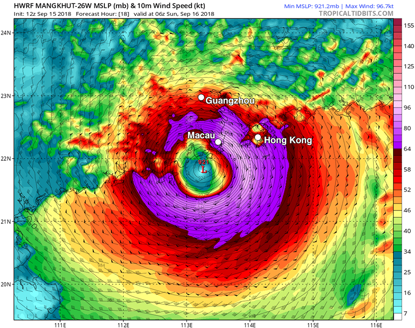
| Figure 1. HWRF model winds and pressure forecast for 2 am EDT Sunday, September 16, 2018, from the 12Z Saturday run of the model. The HWRF model predicted that Mangkhut would make landfall near just west of Hong Kong as a borderline Category 2/Category 3 hurricane with winds of 110 - 115 mph and a central pressure of 921 mb. Image credit: Levi Cowan, tropicaltidbits.com. |
Next landfall: Hong Kong and China
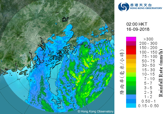
Mangkhut was severely disrupted by its 8-hour trek over northern Luzon Island, which caused the typhoon’s eyewall to collapse, reducing the top sustained winds to 120 mph—Category 3 strength. By 5 pm EDT Saturday, the top winds had falled to 105 mph--Category 2 strength. Satellite images on Saturday afternoon (U.S. EDT) showed the typhoon was slowly re-organizing, taking advantage of low wind shear and very warm ocean temperatures near 28°C (82°F) over the South China Sea. However, with landfall expected to occur shortly after 2 am EDT Sunday, Mangkhut does not have enough time before landfall to rebuild its eyewall, and significant strengthening is not likely. The typhoon will probably be a Category 2 storm with 100 - 105 mph winds when it makes landfall. Heavy rains from the typhoon were already affecting Hong Kong on Saturday afternoon, as seen on Hong Kong radar.
The models are in good agreement on the track of Mangkhut taking the typhoon inland near Macau, just west of Hong Kong. Mangkhut is a huge storm, with hurricane-force winds that extend out up to 90 miles from the center, and tropical storm-force winds that extend out up to 300 miles from the center. This huge wind field is bound to cause a large amount of destruction in Hong Kong, Macau, and Guangzhou, which will all be in the more dangerous right-front quadrant of the storm. The large wind field will also push a large and destructive storm surge inland towards Guangzhou. Guangzhou is the #1 most vulnerable city on the planet to damage from sea level rise and coastal flooding, according to a World Bank report. Hong Kong is not especially vulnerable to storm surge, since it has few low-lying areas.
 |
| Figure 2. Heavy rains from the Typhoon Mangkhut were already affecting Hong Kong at 2 am local time Sunday, as seen on Hong Kong radar. Image credit: Hong Kong Observatory. |
A top-ten most damaging typhoon in Chinese history?
Given the large amount of development that has occurred in the region in recent years, expect Mangkhut to be one of the top-five most expensive typhoons on record in Asia, with damages in excess of $3 billion--and perhaps much higher, according to a Bloomberg interview with disaster modeller Chuck Watson. If Mangkhut's damages exceed $7 billion in China, it would be their most expensive typhoon on record (officially). According to EM-DAT, the most expensive typhoons to hit China (in dollars not adjusted for inflation) were:
1) $6.7 billion, Fitow, 2013
2) $4.3 billion, Rammasun, 2014
3) $4.2 billion, Mujigae, 2015
4) $3.3 billion, Billis, 2006
5) $2.8 billion, Kalmaegi, 2014
6) $2.7 billion, Durian and Utor, 2001
7) $2.7 billion, Winnie, 1997
8) $2.5 billion, Saomai, 2006
9) $2.3 billion, Ferdie, 2016
10) $2.2 billion, Rananim, 2004
Many of these official numbers are almost certainly too low, though, according to experts I’ve talked to. In addition, this list leaves out what was possibly the most destructive Chinese typhoon of all-time, Typhoon Nina of 1975. Nina stalled out and dumped prodigious rains for two days in the Ru River drainage basin upstream of the Banqiao Dam, leading to its collapse and the loss of 171,000 lives, with an area 34 miles long and 8 miles wide wiped out.
The most expensive typhoon for Hong Kong in the EM-DAT database is Category 3 Typhoon Hato of 2017, which did $760 million in damage.
History of major typhoon landfalls in China
China has a long history of major typhoon landfalls. Since record keeping in the Northwest Pacific began in 1945, there have been two Category 5 storms to make landfall in mainland China, twelve Category 4 storms, and nineteen Category 3 storms. The list below was constructed using data from the Joint Typhoon Warning Center (JTWC) for the Northwest Pacific, as plotted on NOAA’s Historical Hurricane Tracks website. These storms were all rated Category 3 or stronger in their last 6-hour position before they made landfall in mainland China. Note that a more accurate list could have been constructed using estimates from the China Meteorological Agency (CMA), whose peak wind estimates sometimes differ from JTWC's by as much as 2-3 storm categories. The CMA has access to landfall observations not readily available to JTWC, as well as damage studies to back up the estimates.
Landfalls South of Hong Kong
—————————————
Category 5:
160 mph, Super Typhoon Rammasun, July 18, 2014
Category 4:
140 mph, Typhoon Hagupit, September 24, 2008
140 mph, Typhoon Ruby, September 5, 1964
140 mph, Typhoon Kate, September 25, 1955
130 mph, Typhoon Vicente, July 23, 2012
130 mph, Typhoon Betty, October 31, 1953
Category 3:
125 mph, Typhoon Sally, September 9, 1996
125 mph, Typhoon Susan, September 18, 1953
125 mph, Typhoon Rose, August 16, 1971
115 mph, Typhoon Pamela, November 8, 1972
115 mph, Typhoon Ophelia, August 14, 1953
115 mph, Typhoon Winnie, July 1, 1964
115 mph, Typhoon Freda, July 15, 1965
115 mph, Typhoon Hato, August 23, 2017
Landfalls North of Hong Kong
—————————————
Category 5:
160 mph, Super Typhoon Cora, September 5, 1966
Category 4:
150 mph, Super Typhoon Saomai, August 10, 2006
150 mph, Super Typhoon Alice, September 3, 1966
150 mph, Super Typhoon Wanda, August 1, 1956
145 mph, Typhoon Rita, September 1, 1953
140 mph, Typhoon Bilis, August 23, 2000
140 mph, Typhoon Nina, August 16, 1953
130 mph, Typhoon Grace, September 4, 1958
Category 3:
125 mph, Typhoon Joan, August 30, 1959
120 mph, Typhoon Khanun, September 11, 2005
120 mph, Typhoon Wipha, September 19, 2007
120 mph, Typhoon Hope, August 2, 1979
120 mph, Typhoon Amy, July 18, 1991
120 mph, Typhoon Dujuan, September 2, 2003
115 mph, Typhoon Usagi, September 22, 2013
115 mph, Typhoon Viola, July 28, 1969
115 mph, Typhoon Abe, September 14, 1993
115 mph, Typhoon Harriet, July 29, 1952
115 mph, Typhoon Tim, July 10, 1994


