| Above: Visible satellite image of Hurricane Beryl taken at 11:21 am EDT July 6, 2018. At the time, Beryl was a Category 1 hurricane with 80 mph winds. Image credit: Levi Cowan, tropicaltidbits.com. |
Surprising and tiny, Hurricane Beryl is headed west-northwest at 15 mph towards the Lesser Antilles Islands after intensifying from a tropical depression to a Category 1 hurricane in just 18 hours. Beryl is a very small storm, with the 11 am Friday NHC advisory warning of hurricane-force winds extending out up to 10 miles from the center, and tropical storm-force winds extending out up to 35 miles from the center. This makes Beryl not much bigger than the smallest Atlantic named storm on record, Tropical Storm Marco of 2008, which had tropical storm-force winds extending out just 12 miles from its center on October 7, 2008, when it was at peak intensity (65 mph sustained winds) in the southern Gulf of Mexico. Beryl had an eye just 6 miles in diameter Friday morning.
The 8 am EDT Friday SHIPS model run diagnosed favorable conditions for intensification, with low wind shear of 5 – 10 knots, a mid-level relative humidity of 60%, and sea surface temperatures (SSTs) near 27°C (81°F). However, a large area of dry air lies just to the north of Beryl, and it is possible at any time that the hurricane could take a gulp of that dry air and suddenly weaken, due to the hurricane’s small size. Satellite images Friday morning showed a distinct eye, but by early afternoon, the eye had filled with clouds, making it uncertain if Beryl was continuing to intensify. The Hurricane Hunters are not scheduled to investigate Beryl until Sunday morning, since the storm is too far from any land bases for their aircraft to fly out of.
 |
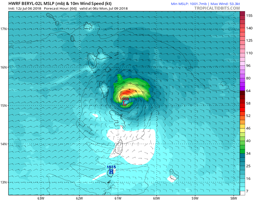
| Figure 1. Predicted winds for Beryl at 2 am EDT Monday, July 9, 2018, from the 12Z Friday, July 6, 2018, run of the HWRF model. Beryl was predicted to be moving through the Lesser Antilles with top winds near 50 kt (57 mph, orange colors). This is very similar to the previous 6Z Friday run of the model. The HWRF was our best intensity model in 2017. Image credit: Levi Cowan, tropicaltidbits.com. |
Forecast for Beryl
The ridge of high pressure steering Beryl will strengthen over the weekend, causing the hurricane to accelerate to a forward speed near 20 mph. This motion should bring it into the Lesser Antilles Islands on Sunday night, with Martinique, Dominica, and Guadaloupe at highest risk of receiving a direct hit. The north side of Beryl will have much stronger winds than the south side, due to the rapid forward motion of the storm. Due to Beryl’s small size, though, it is entirely possible that if it is still at hurricane strength, the storm could slip between a gap in the islands without bringing hurricane-force winds to any islands. Beryl’s intensity at that time is very hard to predict this far in advance, though, since tiny storms like Beryl can rapidly strengthen or weaken due to small changes in their environment.
Beryl will encounter a more hostile environment on Saturday night, when the storm will encounter a region of high wind shear associated with westerly winds from the subtropical jet stream. At that time, Beryl will also be moving with a faster forward speed, which will increase the wind shear for the storm. Beryl will also be entering a region of dry air with a mid-level relative humidity near 50 - 55%. Ocean temperatures will warm a bit, to around 27.5°C (81.5°F), but the one-two punch of high wind shear and dry air may be able to knock a small hurricane like Beryl down to tropical storm strength by the time it reaches the Lesser Antilles Islands on Sunday night. Our top models for forecasting hurricane tracks—the European, GFS, HWRF, and UKMET models—all predicted in their runs from Friday morning that Beryl would be a hurricane or tropical storm on Sunday evening over the Lesser Antilles. Levi Cowan has a good 11 am Friday video discussion of Beryl and 96L.
 |
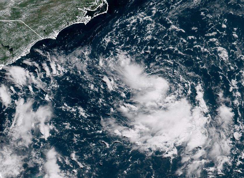
| Figure 2. Visible satellite image of 96L taken at noon EDT July 6, 2018. Image credit: NOAA/RAMMB. |
Tropical depression could develop off the North Carolina coast this weekend
An area of low pressure (96L) located a few hundred miles southeast of the North Carolina coast early Friday afternoon was headed northwest at about 8 mph towards North Carolina, and has the potential to develop into a tropical depression this weekend. Satellite loops early Friday afternoon showed that the system, designated 96L by NHC on Thursday, had a well-defined surface circulation, but its heavy thunderstorm activity was limited. However, the thunderstorm activity had grown more organized since Thursday, with the most intense activity now located near the center of 96L. Sea surface temperatures (SSTs) in this region are near 28.5°C (83°F), about 1°C (1.8°F) above average—plenty warm enough to allow the system to become a tropical depression. Wind shear was a light 5 - 10 knots—favorable for development. There is dry air to the north of the center, which is slowing development.
Steering currents for 96L will grow very weak over the weekend and early next week, and the storm will meander over the very warm waters of the Gulf Stream, a few hundred miles off the North Carolina coast. A cold front will move off the Northeast U.S. coast this weekend, and the tail end of this front will interact with 96L on Sunday, potentially bringing higher wind shear and some dry air to the storm. However, it no longer appears that the upper-level trough of low pressure accompanying this front will be strong enough to pull 96L to the northeast, out to sea. Another trough of low pressure will pass to the north of 96L on Wednesday, and this may be strong enough to turn the storm to the northeast, out to sea, according to the 0Z Friday runs of the European and UKMET models.
With wind shear predicted by the SHIPS model to remain low to moderate through Sunday, 96L will have plenty of time to organize into a tropical depression. The 0Z Friday operational runs of our top three models for predicting tropical cyclone genesis--the European, GFS and UKMET models—all showed development of this system into a tropical depression on Saturday or Sunday. More than 50% of the 50 members of the European model ensemble and the 20 members of the GFS model ensemble also supported this idea. The 0Z and 6Z operational runs of the GFS predicted that 96L would intensify into a hurricane by Wednesday, as did a number of the members of the 0Z GFS ensemble forecast. The 0Z Friday European model and its ensemble members did not predict that 96L would become a hurricane, but the 12Z Friday UKMET model did.
In their 8 am EDT Friday Tropical Weather Outlook, the National Hurricane Center gave 96L 2-day and 5-day odds of development of 70% and 80%, respectively. 96L will be capable of bringing heavy rains to North Carolina’s Outer Banks beginning on Sunday, and I expect that this will become Tropical Storm Chris by early next week. The Hurricane Hunters are scheduled to investigate 96L Saturday afternoon.
 |
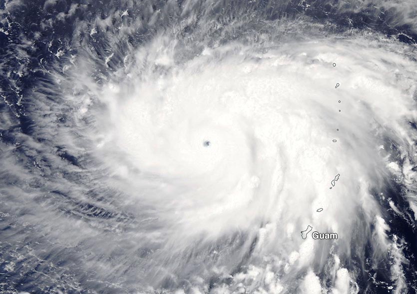
Figure 3. Super Typhoon Maria as seen at 2 am EDT July 6, 2018, a few hundred miles west-northwest of Guam in the Northern Mariana Islands. At the time, Maria was a Category 4 super typhoon with sustained winds of 155 mph. Image credit: NASA. |
Maria becomes a Category 5 super typhoon
Super Typhoon Maria exploded into the Northwest Pacific’s first Category 5 storm of 2018 on Thursday, intensifying from a tropical storm with 70 mph winds to a Category 5 super typhoon with 160 mph winds in just 24 hours. This is one of the fastest intensification rates ever observed for a tropical cyclone. The only comparable intensification rates I am familiar with:
- - Super Typhoon Forrest strengthened by 100 mph in 24 hours in September 1983, according to NOAA's Hurricane Research Division.
- - Hurricane Wilma deepened by 105 mph in 24 hours over the Caribbean Sea in 2005.
- Cyclone Ernie off the coast of northwest Australia (April 7, 2017) has been re-analyzed as having a 110 mph increase in 24 hours (thanks go to Jasper Deng for this).
- - Hurricane Patricia in the eastern Pacific intensified by 120 mph in 24 hours in late October 2015 off Mexico's Pacific coast.
An eyewall replacement cycle that began Thursday night knocked Maria’s winds down by 5 mph at 2 am EDT Friday, making it a top-end Category 4 storm with 155 mph winds, but Maria is expected to take advantage of SSTs near 30°C (86°F) and moderate wind shear of 10 - 20 knots and re-intensify into a Category 5 storm by Friday night. Maria is Earth’s second Category 5 storm of 2018, joining Tropical Cyclone Marcus, which peaked with 160 mph winds on March 21, 2018, in the waters northwest of Australia.
Maria passed just north of Guam as a tropical storm on Thursday, then became the third typhoon of the year in the Northwest Pacific later in the day. As of 11 am EDT Friday (3 am Saturday local time), the Joint Typhoon Warning Center (JTWC) placed the center of Maria about 325 miles northwest of Guam, with the storm heading northwest at 5 mph.
Maria’s northwest to west-northwest track over the next four days will likely bring it over Japan’s Kyushu Islands (which include Okinawa) on Tuesday, with the official JTWC forecast calling for the typhoon to be a Category 3 storm with 120 mph winds then. Maria could go on to affect China by Wednesday.


