| Above: Enhanced infrared image of Tropical Storm Barry at 0346Z Saturday, July 13, 2019 (11:46 pm EDT Friday). Image credit: NASA/MSFC Earth Science Branch. |
Despite its unorthodox evolution on Friday, Tropical Storm Barry posed a major threat to southeast Louisiana and points beyond, with widespread and severe flooding possible over the weekend. As of 11 pm EDT, Barry’s top winds were holding at 65 mph as the storm’s center—located about 75 miles south of Morgan City, Louisiana—crawled west-northwest at just 3 mph. Barry was still expected to reach hurricane strength before moving onto the Louisiana coast on Saturday.
A hurricane warning remained in effect overnight from Intracoastal City to Grand Isle, LA, with tropical storm warnings on either side of this area, as well as for Lake Ponchartrain and Lake Maurepas, including the New Orleans area. See the frequently updated weather.com article for the latest on watches and warnings.
A gawky powerhouse
Barry’s structure on Friday was quite unusual for a tropical storm of its strength. Northerly wind shear through most of Thursday and Friday had pushed dry air into the storm’s north side, yet the overall circulation gradually expanded. As a result, Barry had the look of a strong tropical cyclone whose northern half had been chewed out. Showers and thunderstorms (convection) blossomed and pulsed late Friday along a broad arc south of the storm’s main center. By late Friday, rainbands were pushing onshore all the way from far southeast Texas to the Big Bend of Florida, a testament to the size of Barry’s circulation. Some wind gusts over 40 mph were reported in far southeast Louisiana late Friday, but winds elsewhere remained relatively light.
At the surface, a mesovortex (small-scale low) almost moved onshore in southeast Louisiana Friday afternoon before rotating southward around the main surface low and beneath a huge cluster of intense convection. That cluster broke into two distinct chunks late Friday, giving Barry a truly strange appearance (see embedded tweet below) and leaving it unclear whether Barry would regain a more traditional structure overnight before coming ashore on Saturday.
9pm - GOES-East Satellite imagery of Tropical Storm #Barry over the Gulf of Mexico this evening.
— NWS Mobile (@NWSMobile) July 13, 2019
Want to view more Tropical Storm Barry satellite imagery? Check out this link: https://t.co/mTymmqM8zh pic.twitter.com/NMktnywJUd
By early Saturday morning, it appeared that the eastern chunk was gaining the upper hand, with the storm’s central core finally becoming more symmetric and sporting a large area of very cold cloud tops. This may herald a period of more sustained intensification as long as Barry remains far enough offshore, assisted by very warm surface water temperatures of around 30°C (86°F). Upper-level outflow was steadily improving, even toward the north, where wind shear had suppressed outflow for days.
Water levels were slowly rising Friday night on the south side of Lake Pontchartrain, sitting at 4’ above normal at the Bonnet Carre Spillway at Interstate 10 and more than 3’ above normal at New Canal Station near Lakeshore Park. Water levels were generally holding at 2’ to 3’ above normal on the southeast Louisiana coast. Surge could reach 3 to 6 feet in the storm surge warning area from Intracoastal City to Shell Beach. (See weather.com for the latest on storm surge watches and warnings.)
Barry may also drive a storm surge up the Mississippi River, which has been setting records for prolonged flooding upstream through much of this year. Taking into account the potential surge as well as rainfall, NOAA predicted on Friday morning that the river height at New Orleans could reach 19 feet on Saturday, whereas the levees protecting the city are at least 20’ high (as confirmed by the U.S. Corps of Engineers). A 19-foot crest would be the highest since Feb. 10, 1950. On Friday afternoon, the Mississippi reached 16.93 feet—the highest level observed so late in a calendar year in records going back to at least 1828—before dropping slightly on Friday night.
 |
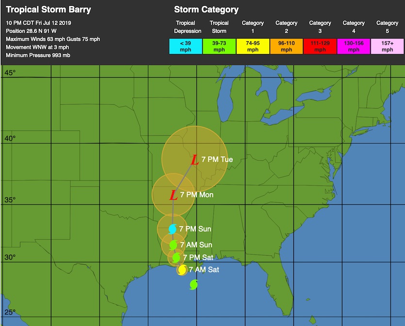
| Figure 1. WU depiction of forecast for Tropical Storm Barry as of 11 pm EDT Friday, July 12, 2019. |
Forecast for Barry
The official NHC forecast continues to bring Barry into the coast southeast of Lafayette on Saturday morning as a Category 1 hurricane, then northward across Louisiana and into Arkansas by Monday.
The heaviest rains from Barry are expected to pivot to its eastern quadrant on Saturday, with a north-to-south corridor of 10-15” amounts and pockets of 20-25” or more. This corridor will likely be east of Barry’s center, somewhere between Lafayette and New Orleans. Widespread and potentially devastating flash flooding is a serious possibility wherever the heaviest rains set up.
There is a HIGH risk of flash flooding over southeastern Louisiana this weekend as #Barry makes landfall, with a significant threat stretching northward into Mississippi. pic.twitter.com/a9yESoyJke
— NWS WPC (@NWSWPC) July 12, 2019
Depending on how Barry evolves, extremely heavy rains could extend well north into Mississippi, with lesser but still-heavy amounts north of Barry's center from Arkansas into Missouri from Sunday into Monday. Soils are considerably wetter than usual toward northern Mississippi, which could exacerbate any flood threat there.
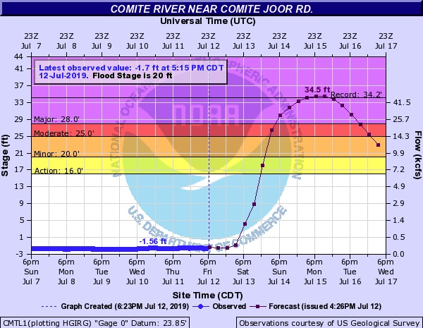
River flooding will become an increasing concern as Barry slogs inland. At least one river—the Comite River near Comite Joor Road, in the northeast Baton Rouge area—is now predicted to crest at record levels on Monday, according to a NOAA forecast issued Friday night. The forecast crest of 34.5 feet would top the 34.22 feet observed in the catastrophic flood of August 2016.
 |
| Figure 2. Observed and predicted heights of the Comite River near Comite Joor Road as of Friday night, July 12, 2019. Image credit: NOAA/NWS/AHPS. |
All-time July rainfall records are possible
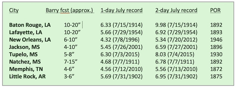
Hot, humid high pressure often dominates weather across the Mississippi Delta in July, prior to peak hurricane season, but Barry could break the mold and produce some of the heaviest July rains ever observed in this area. Here are the 1- and 2-day records for various cities in Barry’s path, along with the year when records began (period of record) and rough estimates of potential rainfall. The New Orleans records shown below are for the international airport site. Two-day rainfall record periods end on the date shown.
 |


