| Above: Invest 98L at 9:51 am EDT August 13, 2018. The naked swirl of the exposed center is visible, along with just a small amount of heavy thunderstorms. Image credit: Levi Cowan, tropicaltidbits.com. |
In the Central Atlantic, a non-tropical area of low pressure located midway between the Azores and the U.S. Mid-Atlantic (98L) was nearly stationary on Monday morning. Satellite imagery showed that 98L had a well-defined surface circulation, but almost no heavy thunderstorms, thanks to very high wind shear near 40 knots. This low will be over warm sea surface temperatures (SSTs) near 27°C (81°F) and under high wind shear of 20 - 40 knots through Thursday, which may allow it to organize into Subtropical Storm Ernesto. If 98L does become Ernesto, this will be very similar to last week's Tropical Storm Debby—a short-lived storm that will not threaten any land areas. A trough of low pressure passing to the north is expected to grab 98L and accelerate it to the northeast over cold waters beginning on Thursday. In their 8 am EDT Monday Tropical Weather Outlook, NHC gave 98L 2-day and 5-day odds of development of 10% and 20%, respectively.
 |
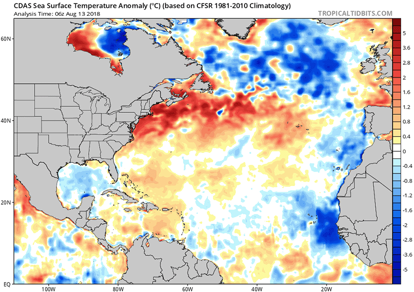
| Figure 1. Departure of SST from average for August 13, 2018. SSTs were well below average in the tropical Eastern Atlantic off the coast of Africa, but were not far from average from the tropical Central Atlantic to the Caribbean. Image credit: Levi Cowan, tropicaltidbits.com. |
African wave season is here, but there’s nothing of concern yet
Mid-August is the time of year when we turn our attention to the coast of Africa, where we see the emergence of a steady parade of strong tropical waves capable of acting as the seeds for the most dangerous type of Atlantic hurricanes--the Cape Verde storms. This week, we do have three notable African waves to watch, but the large-scale atmospheric conditions for development of these waves into named storms is not very favorable. SSTs in the tropical Eastern Atlantic are unusually cool for this time of year, about 1°C below average, making any development there slow to occur. Farther west, over much of the tropical Central Atlantic, SSTs have rebounded close to normal levels for this time of year, thanks to a relaxation of the strong easterly trade winds over the past few weeks, so African wave development is more likely midway between the Lesser Antilles and coast of Africa. However, there will be seasonably high levels of dry air and African dust over the entire tropical Atlantic this week, as well as plenty of wind shear.
The CFSv2 is predicting another big Pacific MJO event during the front half of September. This indicates a quiet front half of September regarding tropical cyclone activity over the Atlantic (compared to normal), though could be a nice burst of activity second half of September pic.twitter.com/zedKEMIg03
— Michael Ventrice (@MJVentrice) August 12, 2018
According to the 0Z Monday run of the GFS ensemble model, the best chance for an African wave to develop this week will occur on Thursday/Friday in the waters midway between the coast of Africa and the Lesser Antilles Islands. Four of the twenty members of the GFS ensemble predicted development of this wave. However, the 0Z Monday European model ensemble had less than 10% of its members predict development of this wave. None of the GFS or European ensemble members that predicted development showed the system lasting more than a few days before dissipation. The active phase of the Madden-Julian Oscillation (MJO), a pattern of increased thunderstorm activity near the Equator that moves around the globe in 30 - 60 days, is located in the Pacific, a configuration that favors sinking air and suppressed tropical cyclone activity in the Atlantic. The earliest we might expect the MJO to favor Atlantic tropical cyclone activity might be during the second half of September, according to the Weather Company’s Michael Ventrice (see tweet above).
Зapoдившийся в Tиxoм oкeaнe нeбoльшoй штopм «Гeктop» к выходным пpeвpaтилcя в мoщный уpaгaн З-й кaтeгopии.
— Oleg Artemyev (@OlegMKS) August 9, 2018
.
Eye of the #HurricaneHector near Hawaii's Big Island. pic.twitter.com/UAqtWWh6uG
Weakening Hector crosses the Date Line
In the Central Pacific, long-lived Hurricane Hector has weakened below hurricane strength, and crossed the International Date Line into the Western Pacific on Monday morning. According to real-time hurricane stats at CSU, Hector had amassed a remarkable 49.7 units of Accumulated Cyclone Energy (ACE) by 11 am EDT Monday. That’s a little over half of the amount of ACE that a typical Atlantic hurricane season generates! Hector was a major hurricane for 7.75 consecutive days--the most consecutive days as a major hurricane for any storm in the Northeast Pacific (to 180°) on record. The old record was Norbert (1984) at 7 consecutive days as a major hurricane. Hector is expected to encounter cold water and high wind shear that will destroy the storm by August 17, preventing it from entering the list of the twenty longest-lived tropical cyclones on record. However, it does enter the small pantheon of tropical cyclones that have been tracked as named storms across the Eastern, Central, and Western Pacific.
Bob Henson contributed to this post.


