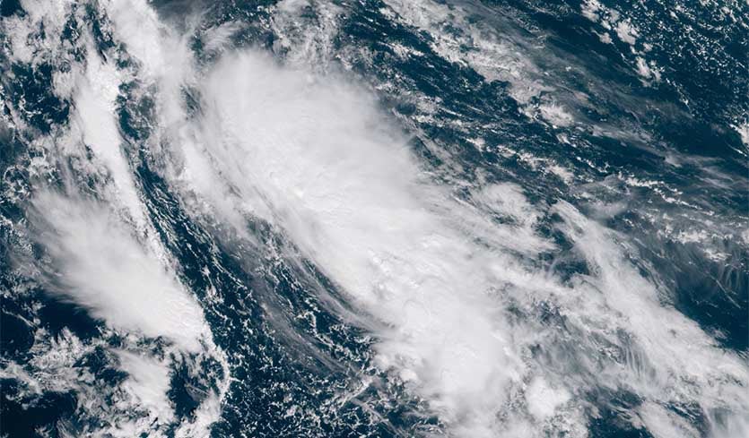
| Above: Visible GOES-16 satellite image of 95L at 11 am EDT Friday, October 26, 2018. The system was elongated from southeast to northwest due to strong upper-level winds out of the southwest that were creating about 20 knots of wind shear. Image credit: RAMMB/CSU/CIRA. |
A low pressure system centered about 1200 miles east-northeast of the northern Leeward islands on Friday morning (95L) has changed little in organization since Thursday night, but is likely to become the Atlantic’s next named storm by Saturday. Bermuda is likely to be the only land area that needs to be concerned with 95L.
Satellite images on Friday afternoon showed that 95L had a moderate-sized area of heavy thunderstorms that were obscuring the surface circulation center. A pass by the ASCAT satellite from 10:02 am EDT Friday showed that this surface center was elongated and not well-defined. The system was headed north at about 10 mph, and was under high wind shear of 20 knots, which was slowing development. The 12Z Friday run of the SHIPS model predicted that shear would remain near 20 knots Friday through Saturday. Water temperatures for 95L on Friday and Saturday were predicted to be near the lower limit typically needed for development of a tropical depression, about 26.5C (80°F).
95L has unanimous support for development from our top three models for predicting tropical cyclone genesis, the European, UKMET, and GFS models. The system is expected to turn to the west early next week towards Bermuda. The 0Z Friday runs of the European and UKMET models predicted that 95L would not be a threat to Bermuda, though, with the storm getting caught up in a trough of low pressure that would pull it northwards out to sea by the middle of next week. However, the 0Z, 6Z, and 12Z Friday runs of the GFS model predicted that 95L would not recurve to the north, and that it might come close to Bermuda late in the week. In their 8 am EDT Friday Tropical Weather Outlook, NHC gave 95L 2-day and 5-day odds of development of 90%. The next name on the Atlantic list of storms is Oscar, which is the 15th name on the list.
 |
| Figure 1. Enhanced infrared satellite image of Super Typhoon Yutu at 11 am EDT Friday, October 26, 2018. Image credit: RAMMB/CSU/CIRA. |
Yutu rages onward as Northern Marianas face massive recovery effort
Super Typhoon Yutu continued its rampage across the Northwest Pacific on Friday, only a little weaker than when it pummeled the Northern Marianas early Thursday. Thanks to a very supportive environment, Yutu has proven resilient through at least two eyewall replacement cycles, and it has recovered from the latest one. According to the Joint Typhoon Warning Center, Yutu’s top sustained winds as of 11 am EDT Friday had increased slightly, to 155 mph, making it a top-end Category 4 storm. Update: As of 5 pm EDT Friday, Yutu had regained Category 5 strength, according to JTWC, with top sustained winds of 160 mph.
The big change in Yutu’s environment this weekend will be strong southerly wind shear, which will increase to the 20 - 25 knot range by Saturday. The strong shear will eventually push dry air into Yutu’s circulation and weaken the storm, possibly to Category 2 or 3 strength by Monday. The shear may relent early next week, though, allowing Yutu to hold its own from that point onward. As it continues westward over warm sea surface temperatures of around 28°C (82°F) it will reach an area of enhanced oceanic heat content just east of the Philippines. The 0Z Friday runs of the European and GFS models bring Yutu into the northern Philippines island of Luzon on Tuesday, perhaps as a major Category 3 storm. The official JTWC forecast angles Yutu slightly north of Luzon on Wednesday, in line with some GFS ensemble members, but recurvature before that point looks increasingly unlikely.
Super #Typhoon #Yutu has exited the #MarianaIslands packing impressive winds of 145 KTS (167 MPH) with gusts to 175 KTS (201 MPH). JTWC expects this intensity to be maintained through the next 24 hours as the storm moves WNW. (JMA Himawari imagery) pic.twitter.com/kw6TLbeC1C
— NASA SPoRT (@NASA_SPoRT) October 25, 2018
At least one person was killed and 133 hospitalized in Saipan after Yutu tore through the U.S. Commonwealth of the Northern Marianas Islands (CNMI). More than 50,000 gallons of water and 260,000 meals sent to Guam in advance of last month's Typhoon Mangkhut are being diverted to the Northern Mariana Islands, according to FEMA. “There’s a lot of damage and destruction. It’s like a small war just passed through,” Gregorio Kilili Camacho Sablan, the CNMI’s delegate to Congress, told the Associated Press. “It’s going to take weeks probably to get electricity back to everybody.”
 |
| Figure 2. A damaged plane sits at the airport after Super Typhoon Yutu hit the U.S. Commonwealth of the Northern Mariana Islands, Friday, Oct. 26, 2018, in Garapan, Saipan. Residents of the U.S. territory are preparing for months without electricity or running water after the islands were slammed Thursday with the strongest storm to hit any part of the world this year. Image credit: AP Photo/Dean Sensui. |
Reports have been sketchy from the CNMI island of Tinian, just south of Saipan, which was encompassed by Yutu’s eye on Thursday. Tinian has about 3100 residents compared to Saipan’s 48,000. Tinian mayor Joey Patrick San Nicolas told Reuters on Thursday: "Many homes have been destroyed, our critical infrastructure has been compromised, we currently have no power and water at this time and our ports are inaccessible.”
We continue to work with partners to bring in people & supplies to support #CNMI’s response & recovery efforts after #Yutu.
— FEMA (@fema) October 26, 2018
@FEMA Federal Coordinating Officer Bern Ruiz on Tinian earlier today with local officials surveying damage. Credit: Gov. Ralph DLG. Torres pic.twitter.com/GfbhGfSPgq
U.S. military installations on the Northern Marianas, including Tinian, experienced a significant hit. “There have been reports of major damage to structures and property, but all U.S. military personnel are currently accounted for,” Lt. Cmdr. Karl Lettow, a Joint Region Marianas spokesman, told Stars and Stripes via email.
Bob Henson wrote the Yutu section of this post.


