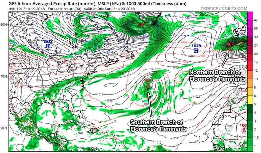
| Above: Forecast pressure and precipitation from the 12Z (8 am EDT) Wednesday run of the GFS model for 18Z (2 pm EDT) Saturday, September 22, 2018. The model was predicting that two separate areas of low pressure formed from the remains of Florence would be over the North Atlantic. Image credit: Levi Cowan, tropicaltidbits.com. |
The remnants of Florence moved off the Northeast U.S. coast on Tuesday as an elongated zone of low pressure. We may not have seen the last of Florence, though. As a high-latitude upper low stretches out the zone of ex-Florence’s low pressure zone even more, there is the potential for two powerful low pressure systems to develop from Florence’s remnants, with one of them transitioning to a tropical or subtropical storm.
This is an animation of the entire life span of Hurricane #Florence since August 29, 2018 when Florence was a tropical wave moving off the west coast of Africa. Besides, Florence, you'll also see Gordon, Helene, Isaac and Joyce during this very active period in the Atlantic Basin pic.twitter.com/9r9V8JTvX9
— NWS WPC (@NWSWPC) September 18, 2018
The most confident forecast is for the northern branch of Florence’s remnants to evolve into a powerful non-tropical low that will intensify just west of Europe, then plow across Ireland and England over the weekend and slam into northern Europe by Monday. It’s been a stormy week already in the U.K., with the remnants of Helene moving through on Tuesday; a midlatitude storm dubbed Ali bringing winds as high as 91 mph in Ireland on Wednesday, resulting in at least one fatality; and another midlatitude storm set to cross the U.K. on Thursday with more wind and heavy rain. The 12Z Wednesday GFS model and prior runs suggest that the northernmost storm emerging from Florence will move through the U.K. (at a latitude still to be determined) with a central pressure around 990 mb, bringing strong winds and dumping widespread rains of 1 - 2 inches.
There is less confidence on what the southern branch of Flo’s remnants might do. This portion of the ex-hurricane is expected to close off into a surface low pressure system on Saturday in the Central Atlantic near 40°N, 40°W, about 500 miles west of the Azores Islands. SSTs are unusually warm in this region, about 25 - 26°C (77 -79°F), which is more than 1°C above average. The low will get cut off from the jet stream and meander in an area of weak steering currents for many days. If the system works its way to the southeast, as recent model runs are suggesting, it will find warmer ocean temperatures and moderate wind shear, which may allow a zombie Florence to rise again. It is unclear, though, if this system were to become a named storm whether or not it would retain the name Florence—that is an NHC judgment call. In their 2 pm EDT Wednesday Tropical Weather Outlook, NHC gave this southern branch of ex-Florence 2-day and 5-day odds of development of 0% and 20%, respectively.
The other area of interest NHC is watching--a tropical wave about 1000 miles east of the Lesser Antilles Islands--appears weak and disorganized on satellite imagery, and has little model support for development. In their 2 pm EDT Wednesday Tropical Weather Outlook, NHC gave this system 2-day and 5-day odds of development of 10%.
Recent runs of the GFS model and its ensembles, plus some ensemble members of the European model, have been suggesting that a tropical wave predicted to emerge from the coast of Africa on Friday might be a threat to develop late next week near the Lesser Antilles Islands. That’s a far-future low-probability forecast, but a reminder that we are still in the peak part of the Atlantic hurricane season, and we still need to watch tropical waves coming off the coast of Africa.
 |
| Figure 1. Damage caused by an apparent tornado is seen on business property on Speeks Road in Chesterfield, Va., on Monday, Sept. 17, 2018. Several tornadoes were spawned by Florence in Virginia on Monday, including one in the Richmond area that was rated EF2 on the Fujita damage scale. One death was reported in Chesterfield County. See the weather.com article for more on the Virginia tornadoes. Image credit: Daniel Sangjib Min/Richmond Times-Dispatch via AP. |
Soil moisture transformation from dry (brown/orange) to near saturation (purple/blue) over North Carolina associated with flooding rainfall from Hurricane #Florence (SPoRT-LIS product incorporating #MRMS precipitation). @NASA_LIS pic.twitter.com/SRgPnz5nL6
— NASA SPoRT (@NASA_SPoRT) September 18, 2018
Florence’s flooding could have been worse
As North Carolina and South Carolina struggle to recover from flood waters that are still rising, and with the storm’s death toll now at 37, it is sobering to think that Florence’s floods could easily have been even worse. Prior to the arrival Hurricane Florence, much of South Carolina and southern parts of North Carolina were experiencing unusually dry soil moisture for this time of year. Despite the capacity for the soils to absorb more moisture than usual from the hurricane’s rains, the historic rainfall was enough to overcome soil moisture deficits, saturate the soil, then create catastrophic flooding (see tweet above). Had the soils already been wetter than average (as they were farther to the north, over Virginia), Florence’s floods would have been even worse. NASA Sport has a blog post with more details; weather.com has a continuously updating feature story on Florence’s flooding.
 |
| Figure 2. TD 19-E over the Gulf of California at 11:30 am EDT September 19, 2018. Image credit: NOAA/RAMMB. |
TD 19-E forms in the Gulf of California
In the Eastern Pacific, TD 19-E formed on Wednesday morning in the Gulf of California. This system is the most serious heavy rainfall threat Mexico has faced thus far in the 2018 hurricane season, with 5 - 10” of rain expected along the path of the depression, and isolated amounts up to 15”. Satellite loops show that TD 19-E has a modest-sized area of heavy thunderstorms, and the system was squished in between Baja California and Mainland Mexico, restricting development. This proximity to land will prevent significant development, despite favorable SSTs near 30°C (86°F) and low wind shear. By Thursday, the north to north-northeast motion of TD 19-E will carry it inland, and the depression will dissipate. Heavy rains from the remants of TD 19-E are expected to move northwards into southeast Arizona, southwest New Mexico, and southwest Texas late this week, bringing widespread areas of 1 – 2” of rain and the risk of flash flooding.
 |
| Figure 3. Sea surface temperatures (SSTs) in the Mediterranean Sea on September 18, 2018 were about 25 – 26.5°C (77 – 80°F) between Sardinia and the coast of Italy, where a Medicane is expected to form on Thursday. Image credit: U.S. Navy. |
A Medicane in the works?
The Mediterranean sea may give birth to an impressive tropical-cyclone-like system called a “Medicane” before the week is out. Medicanes are not considered to be full-fledged tropical systems, and the World Meteorological Organization has not assigned any weather agency with tracking them or giving them names. However, a Medicane can bear many of the hallmarks of a tropical storm, including a warm core, a distinct eye, and spiral banding.
SSTs across the Mediterranean are extremely warm for this (or any) time of year, as reported by Severe Weather Europe on Tuesday. This is largely related to the very hot summer that plagued Europe. Much of the Mediterranean is running 1.5°C to 2.5°C (2.7 – 4.5°F) warmer than average, resulting in SSTs high enough to support tropical cyclone development. Regional high-resolution models are in strong agreement that a low pressure center will develop by Thursday in the Tyrrhenian Sea, between the island of Sardinia and southern Italy. SSTs in this region are around 25 – 26.5°C (77 – 80°F), near the minimum threshold for tropical development. Wind gusts could reach 60 mph, and upslope flow could lead to rainfall totals of up to 300 mm (12”) in eastern Sardinia and 100 mm (4”) in Sicily and Corsica over the next several days, according to Severe Weather Europe. There’s still a good bit of model disagreement on where the emerging Medicane might track, though.
Possible #Medicane resolved in the last few HIRLAM runs.
— wxcharts (@wxcharts) September 18, 2018
These impressive storms have remarkable tropical resemblance, hence the name 'Medicane' (Mediterranean Hurricane) --> https://t.co/BoVinONiR5 pic.twitter.com/GkoMEefABY
Bob Henson co-wrote this post.


