| Above: A disorganized 99L approaches Barbados and the Windward Islands at 11 am EDT September 21, 2019. Image credit: NOAA/RAMMB. |
A tropical wave (99L) located about 300 miles east of the Lesser Antilles Islands at 11 am EDT Saturday was headed west at 15 - 20 mph. Satellite images on Saturday morning showed that 99L had formed a well-defined surface swirl, but heavy thunderstorm activity was meager and disorganized. The surface swirl was well-removed from the heaviest thunderstorms, and 99L will find it challenging to convert the swirl into a well-defined surface circulation that it can consolidate around. The lack of thunderstorms in 99L was due to dry air on the north side; this dry air was being brought into the core of the disturbance by strong upper-level winds out of the northwest. These winds were creating high wind shear of about 20 knots. However, SSTs were warm, near 30°C (86°F), and the atmosphere along the south side of 99L was moist.
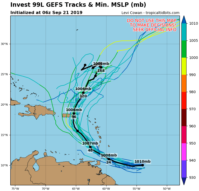
The fast forward motion of 99L will bring it into the Windward Islands on Sunday, and 99L will be visible on Barbados radar by late Saturday afternoon. Wind shear is predicted to remain in the high range, 20 – 25 knots, through Monday, which will likely keep any development slow.
 |
| Figure 1. Predicted path of 99L from the 6Z Saturday, September 21, 2019, run of the GFS model (thick black line) and its ensemble members (thin lines). 99L was predicted to take a path through the Windward Islands on Sunday, then turn north and affect Puerto Rico and the Virgin Islands by Tuesday. Image credit: tropicaltidbits.com. |
There was modest model support for development of 99L, with about 50% of the 21 members of the 0Z Saturday GFS model ensemble forecast and about 30% of the 50+ members of the 0Z Saturday European model ensemble predicting development. In their 8 am EDT Saturday Tropical Weather Outlook, NHC gave 99L 2-day and 5-day odds of development of 50% and 60%, respectively.
Once 99L reaches the Eastern Caribbean on Monday, it will likely slow down and turn to the northwest, following a weakness in the ridge of high pressure to its north caused by the passage of Tropical Storm Jerry. The Leeward Islands should see heavy rain showers from 99L on Monday, and Puerto Rico, the Virgin Islands, and the Dominican Republic should see rain from 99L beginning on Tuesday. A NOAA hurricane hunter aircraft left St. Croix at 11 am EDT Saturday to investigate 99L. The next name on the Atlantic list of storms is Karen.
 |
| Figure 2. Tropical Storm Jerry at 10:20 am EDT September 21, 2019. At the time, Jerry had top winds of 65 mph. Image credit: NOAA/RAMMB. |
Jerry grazes the Leeward Islands, weakens to a tropical storm
Hurricane Jerry passed about 120 – 150 miles to the north of the Leeward Islands on Friday night and Saturday morning, weakening to a tropical storm with 65 mph winds by 2 am EDT Saturday. Jerry’s tropical storm-force winds stayed well north of the islands, as did the storm’s heavy rain bands. As of 11 am EDT Saturday, none of the 20+ personal weather stations in the WU network in the Leeward Islands had recorded any rain from Jerry, though light rain showers had been recorded at several airports in the islands. Heavy rain showers with 1 – 3” of rain are still possible in the Leeward Islands on Saturday afternoon before Jerry pulls away.
Data from the Hurricane Hunters and satellite loops late Saturday morning showed that Jerry was struggling with high wind shear, which had distorted the symmetry of the hurricane, reduced its amount of heavy thunderstorms, and partially exposed the low-level circulation center to view.
Forecast for Jerry
Jerry was headed northwest at 14 mph at 11 am Saturday, with a turn to the north towards Bermuda predicted to occur on Sunday. On this track, Jerry could be a threat to Bermuda on Tuesday. With wind shear expected to be moderate to high over the next five days, ranging from 15 to 35 knots, Jerry is not expected to reintensify beyond Category 1 hurricane status.
Disturbance near eastern Cuba not expected to develop
A tropical wave centered near the eastern tip of Cuba late Saturday morning was spreading disorganized heavy thunderstorms to Haiti, eastern Cuba, the Dominican Republic, and Jamaica. Satellite loops showed that the disturbance had less heavy thunderstorm activity than on Friday, and did not appear to be growing more organized.
Wind shear was high, near 20 – 25 knots, keeping the disturbance disorganized. The disturbance was headed to the west-northwest at about 5 mph into an area of higher wind shear, which makes significant development unlikely. The disturbance will likely bring heavy rains to the region through Sunday. In their 8 am EDT Saturday Tropical Weather Outlook, NHC gave the disturbance 2-day and 5-day odds of development of 0%.
New African tropical wave may develop by Tuesday
A tropical wave expected to emerge from the coast of Africa late Saturday has high model support for development, with the 0Z Saturday operational runs of our three most reliable models for predicting tropical cyclone genesis—the GFS, UKMET, and European—all predicting development by Tuesday. This system is expected to move west then west-northwest later next week. The latest model runs predict that this will most likely be a “fish” storm that will not affect any land areas. In their 8 am EDT Saturday Tropical Weather Outlook, NHC gave the disturbance 2-day and 5-day odds of development of 40% and 90%, respectively.
 |
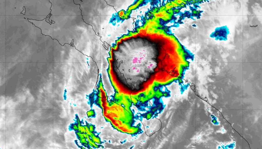
| Figure 3. Infrared satellite image of Hurricane Lorena at 1355Z (9:55 am EDT) Saturday, September 21, 2019. Image credit: tropicaltidbits.com. |
Lorena enters Mexico’s Gulf of California as a hurricane
In the Eastern Pacific, Lorena became a hurricane just south of Mexico’s Gulf of California on Friday morning and then moved into the Gulf while hugging the Baja California Peninsula and maintaining hurricane strength. Along the way, Lorena made a brief landfall near La Ventana, Mexico, at 12:35 am EDT Saturday. As of 11 am EDT Saturday, Lorena was located almost 100 miles northwest of La Paz, Mexico, moving north at 12 mph toward the central Gulf of California, with top sustained winds of 75 mph.
Sea surface temperatures in the southern half of the shallow Gulf of California are extremely high—at or above 31°C (88°F). Access to this oceanic warmth has allowed Lorena to keep generating very strong convection despite the hurricane’s close proximity to the rugged Sierra de la Giganta, whose peaks reach elevations of more than 6000 feet. Wind shear will increase dramatically on Saturday night, and together with land interaction, this should lead to Lorena’s rapid demise. An Air Force reconnaissance plane was scheduled to investigate Lorena on Saturday afternoon.
Low- and mid-level moisture from Lorena will sweep into Arizona from late Sunday into Monday, perhaps triggering heavy showers and thunderstorms on Monday and Tuesday. The NOAA/NWS Storm Prediction Center has taken the unusual step of putting central Arizona, including the Phoenix area, into a Day 3 outlook for a slight chance of severe weather on Monday, noting that “a long duration of thunderstorm activity is possible, with heavy rain, locally damaging wind gusts and hail”. Additional moisture from weakening Tropical Storm Mario may follow Lorena’s remnants into the U.S. Southwest early next week.
Lorena joins a very select group of East Pacific tropical cyclones that have made it into the Gulf of California while at hurricane strength. In reliable satellite-based records, which extend back to the 1970s, only a handful of tropical cyclones have made it as far north as La Paz in the Gulf of California while at hurricane strength. The strongest of these was Liza (1976), which entered the Gulf of California as a Category 4 storm. Liza made landfall on the Gulf’s east coast, about 50 miles north of Los Mochis, with top sustained winds of at least 100 mph. One of Mexico’s worst hurricanes of the 20th century, Liza caused massive flooding and mudslides in Baja California that led to more than 1200 deaths and inflicted more than $100 million in damage (1976 USD).
 |
| Figure 4. Protestors gather in front of the Ministry of Natural Resources and Environment on September 20, 2019, in Bangkok, Thailand. Hundreds of Thai students, adults and foreigners joined together on Friday as part of a global mass day of protest to demand action on climate change. Climate Change Bangkok delivered an open letter to the Ministry of Natural Resources demanding the government declare a climate emergency and commit to complete the phasing out of coal. Image credit: Lauren DeCicca/Getty Images. |
Climate strike galvanizes youth around the world
One of the largest climate-related actions in global history unfolded on Friday, September 20, as an estimated four million people—mainly young people—took part in protests in 163 countries. The burgeoning youth-led movement, which has gone by the hashtag #ClimateStrike, is being driven by organizers that span myriad cultures and geography. The most prominent voice to date has been Swedish 16-year-old Greta Thunberg, whose solo protests outside the Swedish Parliament every Friday starting last fall eventually drew global attention.
"You must do the impossible. Because giving up can never ever be an option."
— Greta Thunberg (@GretaThunberg) September 19, 2019
Here is my full speech from the US Congress in print.https://t.co/8KCBeI3klW
Thunberg was in New York on Friday after taking a solar-power-fueled yacht across the Atlantic and speaking before the U.S. Congress on Thursday, where she said: “Stop pretending that you, your business idea, your political party or plan will solve everything. We must realize that we don’t have all the solutions yet….no matter how political the background to this crisis may be, we must not allow this to continue to be a partisan political question. The climate and ecological crisis is beyond party politics. And our main enemy right now is not our political opponents. Our main enemy now is physics. And we cannot make ‘deals’ with physics.”
THIS WAS THE BEST WAY TO WAKE UP! #CLIMATESTRIKE
— Mike Hudema (@MikeHudema) September 21, 2019
5225 events
In 156 countries
On all 7 continents
And counting! And events happening all week!#ClimateStrike #FridaysForFutures #FridayMotivation #FridayThoughts #GreenNewDeal #Go100re @GretaThunberg #Melbourne pic.twitter.com/fVvzXRmuls
Amazing! Yesterday, an estimated 4 million people in 160+ countries demonstrated for climate action. One of the largest political demonstrations in world history. #ClimateStrike
— Robert Rohde (@RARohde) September 21, 2019
But the hard work is still ahead, rapidly cutting carbon emissions to stabilize the climate. pic.twitter.com/L3gNjYjkFF
Bob Henson co-wrote this post.


